Rural Municipality of Sasman No. 336

Last updated

Sasman No. 336
Rural Municipality of Sasman No. 336
SK RM 336 Sasman.svg
Location of the RM of Sasman No. 336 in Saskatchewan
Coordinates: 51°54′14″N103°29′53″W / 51.904°N 103.498°W / 51.904; -103.498 [1]
Country Canada
Province Saskatchewan
Census division 10
SARM division 4
Formed [2] January 1, 1913
Government
[3]
   Reeve Dwayne Nakrayko
  Governing bodyRM of Sasman No. 336 Council
  AdministratorMichael Rattray
  Office location Kuroki
Area
 (2016) [4]
  Land1,006.49 km2 (388.61 sq mi)
Population
 (2016) [4]
  Total765
  Density0.8/km2 (2/sq mi)
Time zone CST
  Summer (DST) CST
Area code(s) 306 and 639

The Rural Municipality of Sasman No. 336 (2016 population: 765) is a rural municipality (RM) in the Canadian province of Saskatchewan within Census Division No. 10 and SARM Division No. 4.

Contents

History

The RM of Sasman No. 336 incorporated as a rural municipality on January 1, 1913. [2] The RM's name is a portmanteau of Saskatchewan and Manitoba. [5]

Geography

Communities and localities

The following urban municipalities are surrounded by the RM.

Villages

The following unincorporated communities are within the RM.

Organized hamlets [6]
Localities

Demographics

Population history
(1981–2016)
YearPop.±%
19811,433    
19861,372−4.3%
19911,205−12.2%
1996 1,031−14.4%
2001 1,004−2.6%
2006 960−4.4%
2011 818−14.8%
2016 765−6.5%
Source: Statistics Canada via Saskatchewan Bureau of Statistics [7] [8]

In the 2021 Census of Population conducted by Statistics Canada, the RM of Sasman No. 336 had a population of 813 living in 362 of its 607 total private dwellings, a change of

In the 2016 Census of Population, the RM of Sasman No. 336 recorded a population of 765 living in 328 of its 568 total private dwellings, a

Attractions

Government

The RM of Sasman No. 336 is governed by an elected municipal council and an appointed administrator that meets on the second Tuesday of every month. [3] The reeve of the RM is Dwayne Nakrayko while its administrator is Michael Rattray. [3] The RM's office is located in Kuroki. [3]

Transportation

See also

Related Research Articles

<span class="mw-page-title-main">Rural Municipality of Sarnia No. 221</span> Rural municipality in Saskatchewan, Canada

The Rural Municipality of Sarnia No. 221 is a rural municipality (RM) in the Canadian province of Saskatchewan within Census Division No. 6 and SARM Division No. 2. It is located in the south-central portion of the province.

<span class="mw-page-title-main">Rural Municipality of Hudson Bay No. 394</span> Rural municipality in Saskatchewan, Canada

The Rural Municipality of Hudson Bay No. 394 is a rural municipality (RM) in the Canadian province of Saskatchewan within Census Division No. 14 and SARM Division No. 4. At 12,462 km2 (4,812 sq mi) in area, it is the largest rural municipality in Saskatchewan. It is in the northeast-central portion of the province.

<span class="mw-page-title-main">Rural Municipality of Montmartre No. 126</span> Rural municipality in Saskatchewan, Canada

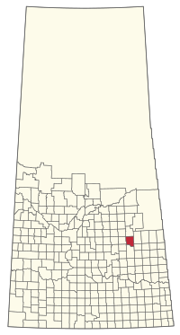
The Rural Municipality of Montmartre No. 126 is a rural municipality (RM) in the Canadian province of Saskatchewan within Census Division No. 6 and SARM Division No. 1. It is located in the southeast portion of the province along Highway 48.

<span class="mw-page-title-main">Rural Municipality of Indian Head No. 156</span> Rural municipality in Saskatchewan, Canada

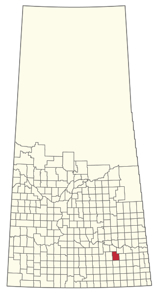
The Rural Municipality of Indian Head No. 156 is a rural municipality (RM) in the Canadian province of Saskatchewan within Census Division No. 6 and SARM Division No. 1. It is located in the southeast portion of the province.

<span class="mw-page-title-main">Rural Municipality of Waverley No. 44</span> Rural municipality in Saskatchewan, Canada

The Rural Municipality of Waverley No. 44 is a rural municipality (RM) in the Canadian province of Saskatchewan within Census Division No. 3 and SARM Division No. 2. Located in the southwest portion of the province, it is adjacent to the United States border, neighbouring Valley County in Montana.

<span class="mw-page-title-main">Rural Municipality of Caron No. 162</span> Rural municipality in Saskatchewan, Canada

The Rural Municipality of Caron No. 162 is a rural municipality (RM) in the Canadian province of Saskatchewan within Census Division No. 7 and SARM Division No. 2. It is located in the southwest portion of the province.

<span class="mw-page-title-main">Rural Municipality of Fertile Valley No. 285</span> Rural municipality in Saskatchewan, Canada

The Rural Municipality of Fertile Valley No. 285 is a rural municipality (RM) in the Canadian province of Saskatchewan within Census Division No. 12 and SARM Division No. 5. It is located in the southwest portion of the province.

<span class="mw-page-title-main">Rural Municipality of Coalfields No. 4</span> Rural municipality in Saskatchewan, Canada

The Rural Municipality of Coalfields No. 4 is a rural municipality (RM) in the Canadian province of Saskatchewan within Census Division No. 1 and SARM Division No. 1. Located in the southeast portion of the province, it is adjacent to the United States, neighbouring Burke County, North Dakota.

<span class="mw-page-title-main">Rural Municipality of Poplar Valley No. 12</span> Rural municipality in Saskatchewan, Canada

The Rural Municipality of Poplar Valley No. 12 is a rural municipality (RM) in the Canadian province of Saskatchewan within Census Division No. 3 and SARM Division No. 2. It is located in the southern portion of the province. It is adjacent to the United States border, neighbouring Daniels County in Montana.

<span class="mw-page-title-main">Rural Municipality of Cote No. 271</span> Rural municipality in Saskatchewan, Canada

The Rural Municipality of Cote No. 271 is a rural municipality (RM) in the Canadian province of Saskatchewan within Census Division No. 9 and SARM Division No. 4.

<span class="mw-page-title-main">Rural Municipality of Coteau No. 255</span> Rural municipality in Saskatchewan, Canada

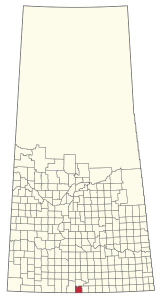
The Rural Municipality of Coteau No. 255 is a rural municipality (RM) in the Canadian province of Saskatchewan within Census Division No. 7 and SARM Division No. 3.

<span class="mw-page-title-main">Rural Municipality of Grass Lake No. 381</span> Rural municipality in Saskatchewan, Canada

The Rural Municipality of Grass Lake No. 381 is a rural municipality (RM) in the Canadian province of Saskatchewan within Census Division No. 13 and SARM Division No. 6.

<span class="mw-page-title-main">Rural Municipality of Good Lake No. 274</span> Rural municipality in Saskatchewan, Canada

The Rural Municipality of Good Lake No. 274 is a rural municipality (RM) in the Canadian province of Saskatchewan within Census Division No. 9 and SARM Division No. 4.

<span class="mw-page-title-main">Rural Municipality of Kellross No. 247</span> Rural municipality in Saskatchewan, Canada

The Rural Municipality of Kellross No. 247 is a rural municipality (RM) in the Canadian province of Saskatchewan within Census Division No. 10 and SARM Division No. 4.

<span class="mw-page-title-main">Rural Municipality of Mount Hope No. 279</span> Rural municipality in Saskatchewan, Canada

The Rural Municipality of Mount Hope No. 279 is a rural municipality (RM) in the Canadian province of Saskatchewan within Census Division No. 10 and SARM Division No. 5.

<span class="mw-page-title-main">Rural Municipality of Lakeview No. 337</span> Rural municipality in Saskatchewan, Canada

The Rural Municipality of Lakeview No. 337 is a rural municipality (RM) in the Canadian province of Saskatchewan within Census Division No. 10 and SARM Division No. 4.

<span class="mw-page-title-main">Rural Municipality of Loon Lake No. 561</span> Rural municipality in Saskatchewan, Canada

The Rural Municipality of Loon Lake No. 561 is a rural municipality (RM) in the Canadian province of Saskatchewan within Census Division No. 17 and SARM Division No. 6.

<span class="mw-page-title-main">Rural Municipality of Moose Range No. 486</span> Rural municipality in Saskatchewan, Canada

The Rural Municipality of Moose Range No. 486 is a rural municipality (RM) in the Canadian province of Saskatchewan within Census Division No. 14 and SARM Division No. 4.

<span class="mw-page-title-main">Rural Municipality of Parkdale No. 498</span> Rural municipality in Saskatchewan, Canada

The Rural Municipality of Parkdale No. 498 is a rural municipality (RM) in the Canadian province of Saskatchewan within Census Division No. 17 and SARM Division No. 6.

<span class="mw-page-title-main">Rural Municipality of St. Peter No. 369</span> Rural municipality in Saskatchewan, Canada

The Rural Municipality of St. Peter No. 369 is a rural municipality (RM) in the Canadian province of Saskatchewan within Census Division No. 15 and SARM Division No. 5.

References

  1. "Pre-packaged CSV files - CGN, Canada/Province/Territory (cgn_sk_csv_eng.zip)". Government of Canada. July 24, 2019. Retrieved May 23, 2020.
  2. 1 2 "Rural Municipality Incorporations (Alphabetical)". Saskatchewan Ministry of Municipal Affairs. Archived from the original on April 21, 2011. Retrieved May 9, 2020.
  3. 1 2 3 4 "Municipality Details: RM of Sasman No. 336". Government of Saskatchewan. Retrieved May 21, 2020.
  4. 1 2 3 "Population and dwelling counts, for Canada, provinces and territories, and census subdivisions (municipalities), 2016 and 2011 censuses – 100% data (Saskatchewan)". Statistics Canada. February 8, 2017. Retrieved May 1, 2020.
  5. Barry, Bill (September 2005). Geographic Names of Saskatchewan . Regina, Saskatchewan: People Places Publishing, Ltd. p.  379. ISBN   1-897010-19-2.
  6. "2019-2020 Rural Revenue Sharing Organized Hamlet Grant". Government of Saskatchewan. Retrieved May 4, 2020.[ permanent dead link ]
  7. "Saskatchewan Census Population" (PDF). Saskatchewan Bureau of Statistics. Archived from the original (PDF) on September 24, 2015. Retrieved May 9, 2020.
  8. "Saskatchewan Census Population". Saskatchewan Bureau of Statistics. Retrieved May 9, 2020.
  9. "Population and dwelling counts: Canada, provinces and territories, census divisions and census subdivisions (municipalities), Saskatchewan". Statistics Canada. February 9, 2022. Retrieved April 13, 2022.
  10. "Margo Recreation Site". BRMB Maps. Mussio Ventures Ltd. Retrieved September 13, 2023.
  11. "Margo Recreation Site". Canadian Geographical Names Database. Government of Canada. Retrieved September 11, 2023.
  12. "30 Free Places to Camp in Saskatchewan". Explore. Explore Magazine. Retrieved April 3, 2024.