Rural Municipality of Victory No. 226

Last updated

Victory No. 226
Rural Municipality of Victory No. 226
SK RM 226 Victory.svg
Location of the RM of Victory No. 226 in Saskatchewan
Coordinates: 50°43′23″N107°29′42″W / 50.723°N 107.495°W / 50.723; -107.495 [1]
Country Canada
Province Saskatchewan
Census division 7
SARM division 3
Formed [2] December 8, 1919
Government
[3]
   Reeve Lee Galbraith
  Governing bodyRM of Victory No. 226 Council
  AdministratorDiane Watt
  Office location Beechy
Area
 (2016) [4]
  Land1,375.44 km2 (531.06 sq mi)
Population
 (2016) [4]
  Total380
  Density0.3/km2 (0.8/sq mi)
Time zone CST
  Summer (DST) CST
Area code(s) 306 and 639

The Rural Municipality of Victory No. 226 (2016 population: 380) is a rural municipality (RM) in the Canadian province of Saskatchewan within Census Division No. 7 and SARM Division No. 3.

Contents

History

The RM of Victory No. 226 incorporated as a rural municipality on December 8, 1919. [2] The first settlers to the area came in the early 1900s. The community of Demaine was established by the summer of 1908 by a band of settlers who hauled supplies from the Riverhurst area to the east, and across the South Saskatchewan River. Originally all supplies had to be moved from other areas as the settlements were being established.

As with current life in rural municipality the first settlers to the area were farmers who began to grow grain. They farmed with teams of oxen and mules prior to the invention of modern-day farming machinery. Eventually two larger settlements were established. These turned into the Village of Beechy and the Organized Hamlet of Demaine.

Geography

Victory No. 226 is bordered by King George No. 256 in the north, Canaan No. 225 in the east, Lake Diefenbaker, which is part of the South Saskatchewan River in the south, and Lacadena No. 228 in the west. With wide open spaces and small rolling hills the land of Victory No. 226 comprises fertile soil perfect for grain farming. Naturally, much of the landscape is covered by grain farming operations.

The Matador Grasslands ( 50°41′28″N107°43′57″W / 50.6911°N 107.7324°W / 50.6911; -107.7324 ) [5] are a protected area about 35 kilometres (22 mi) south-east of Kyle, near the South Saskatchewan River. The grasslands are situated on Crown land and are the "largest remaining uncultivated area of well drained lacustrine clay soils in the Northern Great Plains". [6]

Communities and localities

The following urban municipalities are surrounded by the RM.

Villages

The following unincorporated communities are within the RM.

Organized hamlets [7]

Climate

The rural municipality follows the typical climate and weather patterns of the southern half of Saskatchewan by having harsh, dry cold winters, and warm summers.

Demographics

Population history
(1981–2016)
YearPop.±%
1981575    
1986579+0.7%
1991573−1.0%
1996 494−13.8%
2001 474−4.0%
2006 428−9.7%
2011 443+3.5%
2016 380−14.2%
Source: Statistics Canada via Saskatchewan Bureau of Statistics [8] [9]

In the 2021 Census of Population conducted by Statistics Canada, the RM of Victory No. 226 had a population of 434 living in 143 of its 233 total private dwellings, a change of

In the 2016 Census of Population, the RM of Victory No. 226 recorded a population of 380 living in 121 of its 230 total private dwellings, a

Economy

Its economy is based on agriculture, primarily grain farming with livestock ranching as well.

Government

The RM of Victory No. 226 is governed by an elected municipal council and an appointed administrator that meets on the first Tuesday of every month. [3] The reeve of the RM is Lee Galbraith while the administrator is Diane Watt. [3] The RM's office is located in Beechy. [3]

Prairie Lake Regional Park

Prairie Lake Regional Park ( 50°42′45″N107°23′02″W / 50.7125°N 107.3839°W / 50.7125; -107.3839 ) [11] is a regional park in the RM of Victory about 21 kilometres (13 mi) south of Beechy. The park was founded in 1984 on Cruikshank Bay on the north shore of Lake Diefenbaker. There is a campground, marina, boat launch, playground, fish cleaning station, and a picnic area. The park has access to the lake for swimming, boating, fishing, and other water sports. The campground has electrified sites, washrooms / showers, and a sewer dump. [12] [13]

Notable people

Related Research Articles

<span class="mw-page-title-main">Rural Municipality of Lomond No. 37</span> Rural Municipality in Saskatchewan, Canada

The Rural Municipality of Lomond No. 37 is a rural municipality (RM) in the Canadian province of Saskatchewan within Census Division No. 2 and SARM Division No. 1. Located in the southeast portion of the province, it is south of the city of Weyburn.

<span class="mw-page-title-main">Rural Municipality of Lost River No. 313</span> Rural Municipality in Saskatchewan, Canada

The Rural Municipality of Lost River No. 313 is a rural municipality (RM) in the Canadian province of Saskatchewan within Census Division No. 11 and SARM Division No. 5. Located in the central portion of the province, it is adjacent to the South Saskatchewan River.

<span class="mw-page-title-main">Division No. 7, Saskatchewan</span> Census division of Saskatchewan, Canada

Division No. 7 is one of eighteen census divisions in the province of Saskatchewan, Canada, as defined by Statistics Canada. It is located in the south-central part of the province. The most populous community in this division is Moose Jaw.

<span class="mw-page-title-main">Rural Municipality of Senlac No. 411</span> Rural municipality in Saskatchewan, Canada

The Rural Municipality of Senlac No. 411 is a rural municipality (RM) in the Canadian province of Saskatchewan within Census Division No. 13 and SARM Division No. 6. Located in the west-central portion of the province, it is adjacent to the Alberta boundary.

Beechy is a village in the Canadian province of Saskatchewan within the Rural Municipality of Victory No. 226 and Census Division No. 7. The village is located in the Coteau Hills region of the province, at the intersection of Highway 342 and Highway 737. As of 2006, the village's population is 243.

<span class="mw-page-title-main">Rural Municipality of Manitou Lake No. 442</span> Rural Municipality in Saskatchewan, Canada

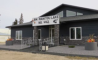
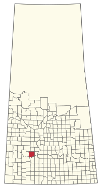
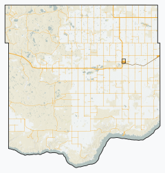
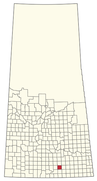
The Rural Municipality of Manitou Lake No. 442 is a rural municipality (RM) in the Canadian province of Saskatchewan within Census Division No. 13 and SARM Division No. 6.

<span class="mw-page-title-main">Rural Municipality of Waverley No. 44</span> Rural Municipality in Saskatchewan, Canada

The Rural Municipality of Waverley No. 44 is a rural municipality (RM) in the Canadian province of Saskatchewan within Census Division No. 3 and SARM Division No. 2. Located in the southwest portion of the province, it is adjacent to the United States border, neighbouring Valley County in Montana.

<span class="mw-page-title-main">Rural Municipality of Mayfield No. 406</span> Rural Municipality in Saskatchewan, Canada

The Rural Municipality of Mayfield No. 406 is a rural municipality (RM) in the Canadian province of Saskatchewan within Census Division No. 16 and SARM Division No. 6.

<span class="mw-page-title-main">Rural Municipality of Moose Mountain No. 63</span> Rural Municipality in Saskatchewan, Canada

The Rural Municipality of Moose Mountain No. 63 is a rural municipality (RM) in the Canadian province of Saskatchewan within Census Division No. 1 and SARM Division No. 1. It is located in the south-east portion of the province.

<span class="mw-page-title-main">Rural Municipality of Norton No. 69</span> Rural Municipality in Saskatchewan, Canada

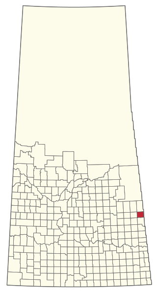
The Rural Municipality of Norton No. 69 is a rural municipality (RM) in the Canadian province of Saskatchewan within Census Division No. 2 and SARM Division No. 2. It is located in the southeast portion of the province.

<span class="mw-page-title-main">Rural Municipality of Biggar No. 347</span> Rural municipality in Saskatchewan, Canada

The Rural Municipality of Biggar No. 347 is a rural municipality (RM) in the Canadian province of Saskatchewan within Census Division No. 12 and SARM Division No. 6.

<span class="mw-page-title-main">Rural Municipality of Snipe Lake No. 259</span> Rural Municipality in Saskatchewan, Canada

The Rural Municipality of Snipe Lake No. 259 is a rural municipality (RM) in the Canadian province of Saskatchewan within Census Division No. 8 and SARM Division No. 3.

<span class="mw-page-title-main">Rural Municipality of Big River No. 555</span> Rural municipality in Saskatchewan, Canada

The Rural Municipality of Big River No. 555 is a rural municipality (RM) in the Canadian province of Saskatchewan within Census Division No. 16 and SARM Division No. 5.

<span class="mw-page-title-main">Rural Municipality of Stanley No. 215</span> Rural Municipality in Saskatchewan, Canada

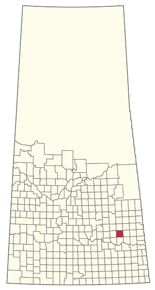
The Rural Municipality of Stanley No. 215 is a rural municipality (RM) in the Canadian province of Saskatchewan within Census Division No. 5 and SARM Division No. 1. It is located in the southeast portion of the province.

<span class="mw-page-title-main">Rural Municipality of Chesterfield No. 261</span> Rural Municipality in Saskatchewan, Canada

The Rural Municipality of Chesterfield No. 261 is a rural municipality (RM) in the Canadian province of Saskatchewan within Census Division No. 8 and SARM Division No. 3.

<span class="mw-page-title-main">Rural Municipality of Garry No. 245</span> Rural Municipality in Saskatchewan, Canada

The Rural Municipality of Garry No. 245 is a rural municipality (RM) in the Canadian province of Saskatchewan within Census Division No. 9 and SARM Division No. 4.

<span class="mw-page-title-main">Rural Municipality of Harris No. 316</span> Rural Municipality in Saskatchewan, Canada

The Rural Municipality of Harris No. 316 is a rural municipality (RM) in the Canadian province of Saskatchewan within Census Division No. 12 and SARM Division No. 5.

<span class="mw-page-title-main">Rural Municipality of Last Mountain Valley No. 250</span> Rural Municipality in Saskatchewan, Canada

The Rural Municipality of Last Mountain Valley No. 250 is a rural municipality (RM) in the Canadian province of Saskatchewan within Census Division No. 11 and SARM Division No. 5.

<span class="mw-page-title-main">Rural Municipality of Parkdale No. 498</span> Rural Municipality in Saskatchewan, Canada

The Rural Municipality of Parkdale No. 498 is a rural municipality (RM) in the Canadian province of Saskatchewan within Census Division No. 17 and SARM Division No. 6.

<span class="mw-page-title-main">Rural Municipality of St. Philips No. 301</span> Rural Municipality in Saskatchewan, Canada

The Rural Municipality of St. Philips No. 301 is a rural municipality (RM) in the Canadian province of Saskatchewan within Census Division No. 9 and SARM Division No. 4.

References

  1. "Pre-packaged CSV files - CGN, Canada/Province/Territory (cgn_sk_csv_eng.zip)". Government of Canada. July 24, 2019. Retrieved May 23, 2020.
  2. 1 2 "Rural Municipality Incorporations (Alphabetical)". Saskatchewan Ministry of Municipal Affairs. Archived from the original on April 21, 2011. Retrieved May 9, 2020.
  3. 1 2 3 4 "Municipality Details: RM of Victory No. 226". Government of Saskatchewan. Retrieved May 21, 2020.
  4. 1 2 3 "Population and dwelling counts, for Canada, provinces and territories, and census subdivisions (municipalities), 2016 and 2011 censuses – 100% data (Saskatchewan)". Statistics Canada. February 8, 2017. Retrieved May 1, 2020.
  5. "Matador Grasslands Protected Area". Canadian Geographical Names Database. Government of Canada. Retrieved October 12, 2023.
  6. https://agbio.usask.ca/research/centres-and-facilities/natural-habitats.php#BiddulphNaturalArea
  7. "2019-2020 Rural Revenue Sharing Organized Hamlet Grant". Government of Saskatchewan. Retrieved May 4, 2020.
  8. "Saskatchewan Census Population" (PDF). Saskatchewan Bureau of Statistics. Archived from the original (PDF) on September 24, 2015. Retrieved May 9, 2020.
  9. "Saskatchewan Census Population". Saskatchewan Bureau of Statistics. Retrieved May 9, 2020.
  10. "Population and dwelling counts: Canada, provinces and territories, census divisions and census subdivisions (municipalities), Saskatchewan". Statistics Canada. February 9, 2022. Retrieved April 13, 2022.
  11. "Prairie Lake Regional Park". Canadian Geographical Names Database. Government of Canada. Retrieved August 18, 2023.
  12. "Prairie Lake". Regional Parks of Saskatchewan. Saskatchewan Regional Parks. Retrieved August 19, 2023.
  13. "Prairie Lake Regional Park". Tourism Saskatchewan. Government of Saskatchewan. Retrieved August 19, 2023.