Rural Municipality of Corman Park No. 344

Last updated

Corman Park No. 344
Rural Municipality of Corman Park No. 344
RMCormanPark344.jpg
RM office and police station
Corman park logo.png
SK RM 344 Corman Park.svg
Location of the RM of Corman Park No. 344 in Saskatchewan
Coordinates: 52°14′28″N106°40′08″W / 52.241°N 106.669°W / 52.241; -106.669 [1]
Country Canada
Province Saskatchewan
Census division 11
SARM division 5
Federal riding Carlton Trail—Eagle Creek
Saskatoon—Grasswood
Provincial riding Biggar-Sask Valley
Martensville-Warman
Rosetown-Elrose
Saskatoon Stonebridge-Dakota
Formed [2] January 1, 1970
Amalgamated [3] December 31, 1969 (RMs of Cory No. 344, Warman No. 374 and Park No. 375)
Government
[4]
   Reeve Judy Harwood
  Governing bodyRM of Corman Park No. 344 Council
  Chief Administrative OfficerKen Kolb
  Office location Saskatoon
Area
 (2016) [5]
  Land1,911.35 km2 (737.98 sq mi)
Population
 (2021) [5]
  Total8,909
  Density4.7/km2 (12/sq mi)
Time zone CST
  Summer (DST) CST
Postal code
S7K 5W1
Area code(s) 306 and 639
Website Official website

The Rural Municipality of Corman Park No. 344 (2021 population: 8,909) is a rural municipality (RM) in the Canadian province of Saskatchewan within Census Division No. 11 and SARM Division No. 5. Located in the central portion of the province, the RM surrounds the City of Saskatoon.

Contents

History

The RM of Corman Park No. 344 was formed by the amalgamation of three rural municipalities – the RMs of Cory No. 344, Warman No. 374 and Park No. 375. [3] The three RMs were disorganized on December 31, 1969 [6] to enable the incorporation of the RM of Corman Park No. 344 on January 1, 1970. [2]

Heritage properties

Two designated historical properties are located in the RM.

Geography

The South Saskatchewan River flows from the southwest corner to the northeast corner of the RM while the North Saskatchewan River forms the RM's northwest boundary. [9] The RM works closely with the Meewasin Valley Authority to protect the South Saskatchewan River valley. [3]

Communities and localities

The following urban municipalities are surrounded by the RM.

Cities
Towns

The following unincorporated communities are within the RM.

Organized hamlets [10]
Localities

Demographics

Population history
(1981–2016)
YearPop.±%
19816,357    
19866,506+2.3%
19916,809+4.7%
1996 7,152+5.0%
2001 8,093+13.2%
2006 8,349+3.2%
2011 8,354+0.1%
2016 8,568+2.6%
2021 8,909+4.0%
Source: Statistics Canada via Saskatchewan Bureau of Statistics [11] [12]

In the 2021 Census of Population conducted by Statistics Canada, the RM of Corman Park No. 344 had a population of 8,909 living in 3,096 of its 3,280 total private dwellings, a change of

In the 2016 Census of Population, the RM of Corman Park No. 344 recorded a population of 8,568 living in 2,952 of its 3,037 total private dwellings, a

The RM's German Canadian population is much higher proportionately than the national or provincial averages: 43.4% (3,645 persons). [14]

Government

The RM of Corman Park No. 344 is governed by an elected municipal council and an appointed administrator that meets on the second and third Monday of every month. [4] The reeve of the RM is Judy Harwood while its Chief Administrative Officer is Ken Kolb. [4] The RM's office is located in Saskatoon. [4] As of October 2018 the reeve is Judy Harwood, and the eight councillors are: [4]

A majority of voters in a November 2011 plebiscite favoured the council be changed from 11 to 8 councillors, a move that was controversial. The elected councillors of the day requested that the provincial government not take action on the plebiscite. [15] However, the request was ignored and the municipal boundaries were redrawn with 8 divisions. [16] A new council was elected on February 29, 2012, with four incumbents and four new councillors. [17]

Emergency response

The RM of Corman Park No. 344 contracts with the City of Saskatoon and the other municipalities for the provision of fire protection.

The RM operates a police service of 10 officers who work in partnership with the Royal Canadian Mounted Police (RCMP). Corman Park Police Service actively partners with all other law enforcement agencies in the Saskatoon and district police universe including the Saskatoon Police Service and Dalmeny Police Service.

The Corman Park Police Service acts in partnership with the RCMP under the terms of Order in Council (OIC) 109/2001 as amended by OIC 92/2006. The service operates out of the municipal office in Saskatoon. [18]

Attractions

In the RM of Corman Park, along the southern banks of the North Saskatchewan River, near the Highway 16 bridge, is Borden Bridge Recreation Site ( 52°22′40″N107°08′31″W / 52.3779°N 107.1419°W / 52.3779; -107.1419 ). [19] The 15-hectare park has a campground and picnic area as well as access to the North Saskatchewan River and the abandoned Borden Bridge. [20] [21]

The RM of Corman Park is home to a Super Dual Auroral Radar Network radar site operated by the University of Saskatchewan.

Cranberry Flats Conservation Area

The Cranberry Flats Conservation Area ( 52°01′52″N106°42′02″W / 52.0311°N 106.7005°W / 52.0311; -106.7005 ) is a regional park operated by the Meewasin Valley Authority along the banks of the South Saskatchewan River about 8 kilometres (5.0 mi) south of Saskatoon. [22] The park is a "sand-based conservation area" with sandy beaches, self-guided nature trails, and a lookout. Access is from Highway 219. [23] Adjacent to Cranberry Flats, in the middle of the river, is a protected area called Wilson Island. On the opposite shore is Poplar Bluffs Conservation area [24] and about 7 km (4.3 mi) to the south is Beaver Creek Conservation Area. These sites are also operated by the Meewasin Valley Authority.

Transportation

Rail [25]
Air

See also

Related Research Articles

<span class="mw-page-title-main">Saskatoon</span> Largest city in Saskatchewan, Canada

Saskatoon is the largest city in the Canadian province of Saskatchewan. It straddles a bend in the South Saskatchewan River in the central region of the province. It is located along the Trans-Canada Yellowhead Highway, and has served as the cultural and economic hub of central Saskatchewan since its founding in 1882 as a Temperance colony.

<span class="mw-page-title-main">Rural Municipality of Aberdeen No. 373</span> Rural municipality in Saskatchewan, Canada

The Rural Municipality of Aberdeen No. 373 is a Rural Municipality (RM) in the Canadian province of Saskatchewan within Census Division No. 15 and SARM Division No. 5. It is located on the South Saskatchewan River.

<span class="mw-page-title-main">Dalmeny, Saskatchewan</span> Town in Saskatchewan, Canada

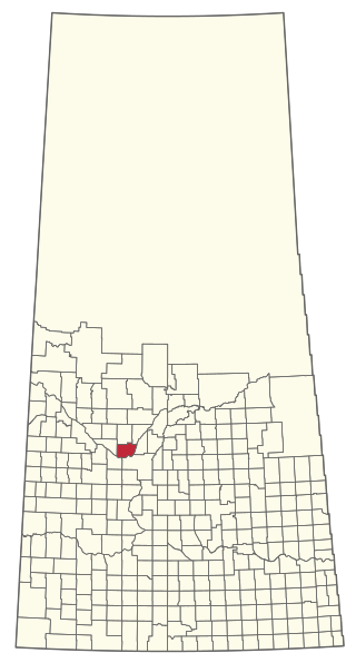
Dalmeny is a town in the central part of Saskatchewan, Canada, named after Dalmeny, Scotland. The town is located in the rural municipality of Corman Park, and is about 26.8 km north of Saskatoon. The Dominion Land Survey description of Dalmeny's location is Section 10 Twp 39 Rge 6 W3.

<span class="mw-page-title-main">Martensville</span> City in Saskatchewan, Canada

Martensville is a city located in Saskatchewan, Canada, just 8 kilometres (5.0 mi) north of Saskatoon, 10 kilometres (6.2 mi) west of the city of Warman and 14 kilometres (8.7 mi) southwest of Clarkboro Ferry which crosses the South Saskatchewan River. It is a bedroom community of Saskatoon. It is surrounded by the Rural Municipality of Corman Park No. 344. The community is served by the Saskatoon/Richter Field Aerodrome located immediately west of the city across Highway 12, as well as by Saskatoon's John G. Diefenbaker International Airport, only a few miles to the south.

<span class="mw-page-title-main">Langham, Saskatchewan</span> Town in Saskatchewan, Canada

Langham is a town in Saskatchewan, Canada. It is located on Highway 16, 35 kilometres northwest of the city of Saskatoon. The 2011 census reported a population of 1,290, with 489 homes in the community.

<span class="mw-page-title-main">Rural Municipality of Arm River No. 252</span> Rural municipality in Saskatchewan, Canada

The Rural Municipality of Arm River No. 252 is a rural municipality (RM) in the Canadian province of Saskatchewan within Census Division No. 11 and SARM Division No. 5. It is located along Highway 11 between Saskatoon and Regina.

<span class="mw-page-title-main">Rural Municipality of Colonsay No. 342</span> Rural municipality in Saskatchewan, Canada

The Rural Municipality of Colonsay No. 342 is a rural municipality (RM) in the Canadian province of Saskatchewan within Census Division No. 11 and SARM Division No. 5. it is located east of the City of Saskatoon.

<span class="mw-page-title-main">Saskatchewan Highway 16</span> Highway in Saskatchewan, Canada

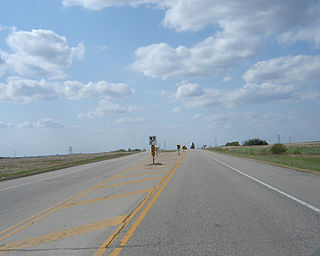
Highway 16 is a provincial highway in the Canadian province of Saskatchewan. It is the Saskatchewan section of the Yellowhead Highway, and also the Trans-Canada Highway Yellowhead section. The main purpose of this highway is to connect Saskatchewan with Canadian cities such as Edmonton and Winnipeg. The highway runs from the Alberta boundary in Lloydminster to the Manitoba boundary near Marchwell. Major cities it passes through are Saskatoon, North Battleford in the central part of the province, Yorkton in the far east and Lloydminster to the far west.

<span class="mw-page-title-main">Meewasin Valley Authority</span>

The Meewasin Valley Authority is a conservation organization created by the Provincial Government of Saskatchewan in Canada and is dedicated to conserving the cultural and natural resources of the South Saskatchewan River Valley. The authority's activities include education, development and conservation. Centred in Saskatoon, the Conservation Zone of Meewasin runs 60 kilometres (37 mi) along the river valley from the eastern edge of the municipality of Corman Park through Saskatoon to the western edge of Corman Park. The authority is actively involved in the River Landing redevelopment.

<span class="mw-page-title-main">Rural Municipality of Shellbrook No. 493</span> Rural municipality in Saskatchewan, Canada

The Rural Municipality of Shellbrook No. 493 is a rural municipality (RM) in the Canadian province of Saskatchewan within Census Division No. 16 and SARM Division No. 5. It is located in the north-central portion of the province west of the city of Prince Albert.

<span class="mw-page-title-main">Rural Municipality of Vanscoy No. 345</span> Rural municipality in Saskatchewan, Canada

The Rural Municipality of Vanscoy No. 345 is a rural municipality (RM) in the Canadian province of Saskatchewan within Census Division No. 12 and SARM Division No. 5. Located in the central portion of the province, it is southwest of the city of Saskatoon.

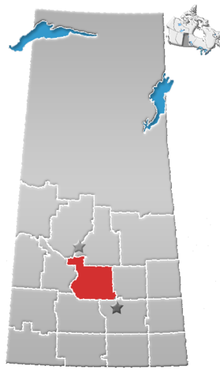
SARM Division No. 5 is a division of the Saskatchewan Association of Rural Municipalities (SARM) within the Canadian province of Saskatchewan. It is located in the north-central area of the province. There are 57 rural municipalities in this division. The current director for Division 5 is Judy Harwood.

<span class="mw-page-title-main">Division No. 11, Saskatchewan</span> Census division of Saskatchewan, Canada

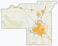
Division No. 11 is one of eighteen census divisions in the province of Saskatchewan, Canada, as defined by Statistics Canada. It is located in the central part of the province and includes the largest city in the province, Saskatoon.

<span class="mw-page-title-main">Warman, Saskatchewan</span> City in Saskatchewan, Canada

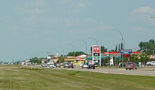
Warman (/ˈwɔrmən/) is the ninth-largest city in the province of Saskatchewan, Canada. It is located approximately 20 kilometres (12 mi) north of the city of Saskatoon, and 5 kilometres (3.1 mi) northeast of the city of Martensville. According to the 2021 census, Warman is the fastest growing municipality in Saskatchewan, and was the fastest growing municipality in Canada between 2011 and 2016. Warman is a bedroom community of Saskatoon. The current mayor is Gary Philipchuk.

Highway 305 is a provincial highway in the Canadian province of Saskatchewan. It runs from Highway 16 near Langham to Highway 11 near Warman. It is about 30 kilometres (19 mi) long.

<span class="mw-page-title-main">Rural Municipality of Milton No. 292</span> Rural municipality in Saskatchewan, Canada

The Rural Municipality of Milton No. 292 is a rural municipality (RM) in the Canadian province of Saskatchewan within Census Division No. 13 and SARM Division No. 6. Located in the west-central portion of the province, it is adjacent to the Alberta boundary.

<span class="mw-page-title-main">Rural Municipality of Rosedale No. 283</span> Rural municipality in Saskatchewan, Canada

The Rural Municipality of Rosedale No. 283 is a rural municipality (RM) in the Canadian province of Saskatchewan within Census Division No. 11 and SARM Division No. 5. It is located in the central portion of the province along Highway 11 between Saskatoon and Regina.

<span class="mw-page-title-main">University Heights SDA, Saskatoon</span> Place in Saskatchewan, Canada

University Heights Suburban Development Area (SDA) is an area in Saskatoon, Saskatchewan (Canada). It is a part of the east side community of Saskatoon. It lies (generally) south of the outskirts of the City and the Rural Municipality of Corman Park No. 344, east of the South Saskatchewan River, and Lawson SDA, north of the Lakewood SDA, and Nutana SDA.

<span class="mw-page-title-main">Rural Municipality of Great Bend No. 405</span> Rural municipality in Saskatchewan, Canada

The Rural Municipality of Great Bend No. 405 is a rural municipality (RM) in the Canadian province of Saskatchewan within Census Division No. 16 and SARM Division No. 6. Located in the west-central portion of the province, it is approximately 50 km (31 mi) to the northwest of Saskatoon.

<span class="mw-page-title-main">Saskatoon metropolitan area</span> Metropolitan area in Saskatchewan, Canada

The Saskatoon region is the greater metropolitan area of Saskatoon, Saskatchewan. As of 2021 the Statistics Canada estimates the region's population to be 317,480 people.

References

  1. "Pre-packaged CSV files - CGN, Canada/Province/Territory (cgn_sk_csv_eng.zip)". Government of Canada. July 24, 2019. Retrieved May 23, 2020.
  2. 1 2 "Rural Municipality Incorporations (Alphabetical)". Saskatchewan Ministry of Municipal Affairs. Archived from the original on April 21, 2011. Retrieved January 8, 2017.
  3. 1 2 3 "Governance". Rural Municipality of Corman Park No. 344. Retrieved January 8, 2017.
  4. 1 2 3 4 5 "Municipality Details: RM of Corman Park No. 344". Government of Saskatchewan. Retrieved May 21, 2020.
  5. 1 2 3 "Population and dwelling counts, for Canada, provinces and territories, and census subdivisions (municipalities), 2016 and 2011 censuses – 100% data (Saskatchewan)". Statistics Canada. February 8, 2017. Retrieved May 1, 2020.
  6. "Disorganized Rural Municipalities". Saskatchewan Ministry of Municipal Relations. Archived from the original on February 25, 2012. Retrieved January 8, 2017.
  7. Opimihaw Provincial Heritage Property
  8. Bone Trail Municipal Heritage Property
  9. Rural Municipality of Corman Park No. 344 (Map). Rural Municipality of Corman Park No. 344. September 2019. Retrieved May 8, 2020.
  10. "2019-2020 Rural Revenue Sharing Organized Hamlet Grant". Government of Saskatchewan. Retrieved May 4, 2020.[ permanent dead link ]
  11. "Saskatchewan Census Population" (PDF). Saskatchewan Bureau of Statistics. Archived from the original (PDF) on September 24, 2015. Retrieved April 25, 2022.
  12. "Saskatchewan Census Population". Saskatchewan Bureau of Statistics. Retrieved May 9, 2020.
  13. "Population and dwelling counts: Canada, provinces and territories, census divisions and census subdivisions (municipalities), Saskatchewan". Statistics Canada. February 9, 2022. Retrieved April 13, 2022.
  14. Ethnocultural portrait of Canada, Corman Park No. 344, Saskatchewan
  15. French, Janet (November 19, 2011). "Disregard referendum: Corman Park council asks Minister to ignore vote result". The StarPhoenix . Postmedia Network . Retrieved November 19, 2011.
  16. Couture, Joe (December 12, 2011). "Saskatchewan government enacts Corman Park boundary, council changes". The StarPhoenix . Postmedia Network . Retrieved March 16, 2012.
  17. "New 8-person Corman Park council voted in". CBC News. February 29, 2012. Retrieved March 16, 2012.
  18. "Corman Park No. 344". SaskBiz.ca. Retrieved March 16, 2012.
  19. "Borden Bridge Recreation Site". Canadian Geographical Names Database. Government of Canada. Retrieved March 15, 2023.
  20. "Borden Bridge Campground". Tourism Saskatchewan. Government of Saskatchewan. Retrieved March 15, 2023.
  21. "Borden Bridge Recreation Site". BRMB. Mussio Ventures Ltd. Retrieved March 15, 2023.
  22. "Cranberry Flats Conservation Area". Meewasin. Retrieved December 7, 2022.
  23. "Cranberry Flats Conservation Area". Tourism Saskatchewan. Government of Saskatchewan. Retrieved December 7, 2022.
  24. "Poplar Bluffs Canoe Launch". Tourism Saskatoon. Retrieved December 7, 2022.
  25. Canadian Maps: January 1925 Waghorn's Guide. Post Offices in Man. Sask. Alta. and West Ontario.