Sedco Hills, California

Last updated
Sedco Hills, California
CDP
Riverside County California Incorporated and Unincorporated areas Sedco Hills Highlighted.svg
Location in Riverside County and the state of California
Coordinates: 33°38′26″N117°17′9″W / 33.64056°N 117.28583°W / 33.64056; -117.28583 Coordinates: 33°38′26″N117°17′9″W / 33.64056°N 117.28583°W / 33.64056; -117.28583
Country United States
State California
County Riverside
Area
  Total1.6 sq mi (4.2 km2)
  Land1.6 sq mi (4.2 km2)
  Water0 sq mi (0 km2)
Elevation
1,276 ft (389 m)
Population
 (2000)
  Total3,078
  Density1,923.8/sq mi (732.9/km2)
Time zone UTC-8 (PST)
  Summer (DST) UTC-7 (PDT)
ZIP code
92595
Area code(s) 951
FIPS code 06-70784
GNIS feature ID1652794

Sedco Hills is a former census-designated place (CDP) in Riverside County, California, United States. The population was 3,078 at the 2000 census. Sedco Hills became part of the City of Wildomar upon its incorporation on July 1, 2008.

Contents

Geography

Sedco Hills is located at 33°38′26″N117°17′9″W / 33.64056°N 117.28583°W / 33.64056; -117.28583 (33.640690, -117.285842). [1]

According to the United States Census Bureau, the CDP has a total area of 1.6 square miles (4.1 km2), all of it land.

History

The name Sedco comes from the South Elsinore Development Company, a land company that developed the area in the past. The name Sedco Hills has become the informal name of that section of the Temescal Mountains east of Sedco Hills, west of Cottonwood Canyon Creek and south of the San Jacinto River.

Demographics

As of the census [2] of 2000, there were 3,078 people, 1,036 households, and 735 families residing in the CDP. The population density was 1,885.3 inhabitants per square mile (727.9/km2). There were 1,123 housing units at an average density of 687.8 per square mile (265.6/km2). The racial makeup of the CDP was 73.9% White, 3.3% African American, 2.0% Native American, 1.1% Asian, <0.1% Pacific Islander, 16.1% from other races, and 3.6% from two or more races. Hispanic or Latino of any race were 36.3% of the population.

There were 1,036 households, out of which 35.4% had children under the age of 18 living with them, 50.4% were married couples living together, 13.9% had a female householder with no husband present, and 29.0% were non-families. 22.6% of all households were made up of individuals, and 11.8% had someone living alone who was 65 years of age or older. The average household size was 2.97 and the average family size was 3.48.

In the CDP the population was spread out, with 30.1% under the age of 18, 8.7% from 18 to 24, 26.7% from 25 to 44, 19.4% from 45 to 64, and 15.0% who were 65 years of age or older. The median age was 34 years. For every 100 females, there were 97.9 males. For every 100 females age 18 and over, there were 91.8 males.

The median income for a household in the CDP was $28,766, and the median income for a family was $35,481. Males had a median income of $32,679 versus $19,375 for females. The per capita income for the CDP was $13,101. About 16.7% of families and 18.4% of the population were below the poverty line, including 23.6% of those under age 18 and 11.3% of those age 65 or over.

Government

In the California State Legislature, Sedco Hills is in the 28th Senate District , represented by Republican Melissa Melendez, and in the 67th Assembly District , represented by Republican Kelly Seyarto. [3]

In the United States House of Representatives, Sedco Hills is in California's 42nd congressional district , represented by Republican Ken Calvert. [4]

Related Research Articles

<span class="mw-page-title-main">Quartz Hill, California</span> Census-designated place in California, United States

Quartz Hill is a census-designated place (CDP) in Los Angeles County, California, United States. The population was 10,912 at the 2010 census, up from 9,890 at the 2000 census. The name is also shared with the neighboring district areas of its border cities, Palmdale, and Lancaster. Quartz Hill was once home to the Quartz Hill Airport. According to the Greater Antelope Valley Economic Alliance report of 2009, the Palmdale / Lancaster urban area of which Quartz Hill is a part, has a population of 483,998.

<span class="mw-page-title-main">Foothill Ranch, California</span> Human settlement in California, United States of America

Foothill Ranch is a master planned community in Orange County, California, United States. The population was 10,899 at the 2000 census. Foothill Ranch was incorporated into the city of Lake Forest, California, in 2000. Prior to that, it was a census-designated place.

Newport Coast, Newport Beach Community of Newport Beach in California, United States

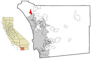
Newport Coast is a community south of the main body of the city of Newport Beach, California. It was a separate census-designated place in Orange County, California, United States, until 2001, when it was annexed into Newport Beach. Newport Beach, California's estimated population is 86,160 according to the most recent United States census estimates. Newport Beach, California is the 96th largest city in California based on official 2017 estimates from the US Census Bureau.

San Joaquin Hills is a neighborhood in Newport Beach, Orange County, California As of the 2000 census, the population was 2,959. San Joaquin Hills was annexed into Newport Beach on January 1, 2002. Prior to 2002, it was a census-designated place.

North Tustin, California Census-designated place in California, United States

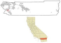
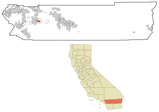
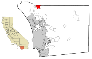
North Tustin is a census-designated place and unincorporated community in Orange County, California. The population was 24,917 at the 2010 census, up from 24,044 at the 2000 census. It is Orange County's largest census-designated place and the largest unincorporated community in Orange County. It is outside the city limits of Tustin and has 92705 and 92780 ZIP Codes. The CDP name was changed from Tustin Foothills in 2005.

Clio, California Census-designated place in California, United States

Clio is a census-designated place in Plumas County, California, United States. Clio is located 23 miles (37.0 km) southeast of Quincy. The population was 66 at the 2010 census, down from 90 at the 2000 census.

Home Gardens, California Census-designated place in California, United States

Home Gardens is a census-designated place (CDP) in Riverside County, California, United States. It is within the City of Corona's sphere of influence. The population was 11,203 at the 2020 census, down from 11,507 at the 2010 census.

Homeland, California Census-designated place in California, United States

Homeland is a census-designated place (CDP) in Riverside County, California, United States. The population was 5,969 at the 2010 census, up from 3,710 at the 2000 census.

Nuevo, California Census-designated place in California, United States

Nuevo is a rural community located east of Lake Perris and the city of Perris in Riverside County, California. The population of the census-designated place (CDP) is 7,033 according to the 2020 census, up from 6,447 at the 2010 census.

Quail Valley is a former census-designated place (CDP) in Riverside County, California, United States. On October 1, 2008, the community along with the neighboring communities of Sun City and Menifee incorporated as the City of Menifee.

<span class="mw-page-title-main">Valle Vista, California</span> Census-designated place in California, United States

Valle Vista is a census-designated place (CDP) in Riverside County, California, United States and is located in the San Jacinto Valley. Some areas of Valle Vista are considered to be part of both unincorporated San Jacinto and Hemet but have yet to be incorporated. The population was 11,036 at the 2010 census, up from 8,356 at the 2000 census.

<span class="mw-page-title-main">Winchester, California</span> Census-designated place in California, United States

Winchester is a census-designated place (CDP) in Riverside County, California, USA. As of the 2010 census, the CDP had a total population of 2,534, up from 2,155 at the 2000 census.

Lenwood, California Census-designated place in California, United States

Lenwood is a census-designated place (CDP) in the Mojave Desert near Barstow, in San Bernardino County, California.

Mountain View Acres, California Census-designated place in California, United States

Mountain View Acres is a census-designated place (CDP) in the Victor Valley of the Mojave Desert, within San Bernardino County, California.

Camp Pendleton Mainside, California Census-designated place in California, United States

Camp Pendleton Mainside is a census-designated place (CDP) in San Diego County, California, located at the southeast corner of the Marine Corps Base Camp Pendleton. Per the 2020 census, the population was 9,683. It was formerly known as Camp Pendleton North, but its name was changed for the 2020 Census. Along with Camp Pendleton South, it is one of two CDPs located on the base.

Hidden Meadows, California Census designated place in California, United States

Hidden Meadows is a census-designated place (CDP) near Escondido in San Diego County, California. The population was 3,485 at the 2010 census, up from 3,463 at the 2000 census.

Lake San Marcos, California Census-designated place in California, United States

Lake San Marcos is a census-designated place (CDP) in the North County region of the San Diego metropolitan area. It is nominally independent of San Marcos proper, but functionally subservient to the city.

<span class="mw-page-title-main">Rainbow, California</span> Census designated place in California, United States

Rainbow is a census designated place (CDP) in northern San Diego County in the U.S. state of California. The population was 1,832 at the 2010 census, down from 2,026 at the 2000 census.

China Lake Acres, California Census-designated place in California, United States

China Lake Acres is a census-designated place (CDP) in Kern County, California, United States. The population was 1,876 at the 2010 census, up from 1,761 at the 2000 census.

<span class="mw-page-title-main">Searles Valley, California</span> Census-designated place in California, United States

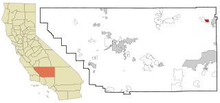
Searles Valley is a census-designated place (CDP) in the Searles Valley of the Mojave Desert, in northwestern San Bernardino County, California.

References

  1. "US Gazetteer files: 2010, 2000, and 1990". United States Census Bureau. 2011-02-12. Retrieved 2011-04-23.
  2. "U.S. Census website". United States Census Bureau . Retrieved 2008-01-31.
  3. "Statewide Database". UC Regents. Retrieved December 8, 2014.
  4. "California's 42nd Congressional District - Representatives & District Map". Civic Impulse, LLC.