
The Blue Mountains are a mountainous region and a mountain range located in New South Wales, Australia. The region borders on Sydney's metropolitan area, its foothills starting about 50 kilometres (31 mi) west of centre of the state capital, close to the major suburb of Penrith. The public's understanding of the extent of the Blue Mountains is varied, as it forms only part of an extensive mountainous area associated with the Great Dividing Range. Officially the Blue Mountains region is bounded by the Nepean and Hawkesbury rivers in the east, the Coxs River and Lake Burragorang to the west and south, and the Wolgan and Colo rivers to the north. Geologically, it is situated in the central parts of the Sydney Basin.

The Blue Mountains National Park is a protected national park that is located in the Blue Mountains region of New South Wales, in eastern Australia. The 267,954-hectare (662,130-acre) national park is situated approximately 80 kilometres (50 mi) west of Sydney, and the park boundary is quite irregular as it is broken up by roads, urban areas and inholdings. Despite the name mountains, the area is an uplifted plateau, dissected by a number of larger rivers. The highest point in the park is Mount Werong at 1,215 metres (3,986 ft) above sea level; while the low point is on the Nepean River at 20 metres (66 ft) above sea level as it leaves the park.
The Budderoo National Park is a 7,219-hectare (17,840-acre) national park that is located in the Illawarra region of New South Wales, Australia; situated approximately 99 kilometres (62 mi) south southwest of Sydney.

Ku-ring-gai Chase National Park is a national park on the northern side of Sydney in New South Wales, Australia. The 14,977-hectare (37,010-acre) park is 25 kilometres (16 mi) north of the Sydney Central Business District and generally comprises the land east of the M1 Pacific Motorway, south of the Hawkesbury River, west of Pittwater and north of Mona Vale Road. It includes Barrenjoey Headland on the eastern side of Pittwater.

The Morton National Park is a 199,745-hectare (493,580-acre) national park located in the Southern Highlands, South Coast and Illawarra regions of New South Wales, Australia, situated approximately 170 kilometres (110 mi) south southwest of Sydney.

Mount Field National Park is a national park in Tasmania, Australia, 64 km northwest of Hobart. The landscape ranges from eucalyptus temperate rainforest to alpine moorland, rising to 1,434 metres (4,705 ft) at the summit of Mount Field West.

Blackheath is an Australian town located near the highest point of the Blue Mountains, between Katoomba and Mount Victoria in New South Wales. The town's altitude is about 1,065 metres (3,494 ft) AHD and it is located about 120 kilometres (75 mi) west north-west of the Sydney central business district, 11 kilometres (6.8 mi) north-west of Katoomba, and about 30 kilometres (19 mi) south-east of Lithgow.

The Jamison Valley forms part of the Coxs River canyon system in the Blue Mountains of New South Wales, Australia. It is situated approximately 100 kilometres west of Sydney, capital of New South Wales, and a few kilometres south of Katoomba, the main town in the Blue Mountains.

Mount Gambier is the second most populated city in South Australia with an estimated urban population of 29,639. The city is located on the slopes of Mount Gambier (volcano) in the south east of the state, about 450 kilometres (280 mi) south-east of the capital Adelaide and just 17 kilometres (11 mi) from the Victorian border, it is the most important settlement in the Limestone Coast region and the seat of government for both the City of Mount Gambier and the District Council of Grant.

The Limestone Coast is a name used since the early twenty-first century for a South Australian government region located in the south east of South Australia which immediately adjoins the continental coastline and the Victorian border. The name is also used for a tourist region and a wine zone both located in the same part of South Australia.

The Blue Lake is a large, monomictic, crater lake located in a dormant volcanic maar associated with the Mount Gambier maar complex. The lake is situated near Mount Gambier in the Limestone Coast region of South Australia, and is one of four crater lakes on Mount Gambier maar. Of the four lakes, only two remain, as the other two have dried up over the past 30 to 40 years as the water table has dropped.

The Adelaide Hills region is located in the southern Mount Lofty Ranges east of the city of Adelaide in the state of South Australia. The largest town in the area, Mount Barker, has a population of around 29,000 and is one of Australia's fastest growing towns.
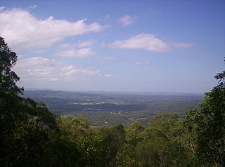
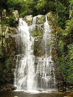
The D'Aguilar Range is a mountain range near Brisbane, Queensland, Australia. The town of Dayboro is situated on the lower foothills midway along the range and the Sunshine Coast Hinterland town of Mooloolah lies at the northernmost point of the range. Many residential areas line its eastern slopes including the town of Samford and the suburb of Ferny Hills. In the west, numerous ridges and gullies are heavily forested and designated as state forest or national park.

Tourism in Sydney, Australia forms an important part of the city's economy. The city received 10.67 million domestic visitors and 4.05 million international visitors in year ending September 2018. The most famous attractions include the Sydney Opera House, and the Sydney Harbour Bridge. Other attractions include the Sydney Mardi Gras, Royal Botanical Gardens, Luna Park, the beaches and Sydney Tower.

The District Council of Grant is a local government area located in the Limestone Coast region of South Australia, and is the southernmost council in the state.

Point Lookout, a mountain on the Snowy Range, a spur of the Great Dividing Range, is located in the New England National Park on the eastern edge of the Northern Tablelands in the New England region of New South Wales, Australia.

The Watchman Lookout Station No. 168 is one of two fire lookout towers in Crater Lake National Park in southern Oregon. For many years, National Park Service personnel used the lookout to watch for wildfires during the summer months. It is also a common hiking destination because of its views of Crater Lake and the surrounding area. The building is unusual because it serves the dual purpose of fire lookout and museum. The Watchman Lookout Station is listed on the National Register of Historic Places.

Mount Gambier is a maar complex in South Australia associated with the Newer Volcanics Province. It contains four lake-filled maars called Blue Lake, Valley Lake, Leg of Mutton Lake, and Brownes Lake. Both Brownes and Leg of Mutton lakes are dry in recent years, due to the lowering of the water table. It is one of Australia's youngest volcanoes, but estimates of the age have ranged from over 28,000 to less than 4,300. The most recent estimate, based on radiocarbon dating of plant fibers in the main crater suggests an eruption a little before 6000 years ago. It is believed to be dormant rather than extinct.

The Kings Tableland is a plateau, located in the Blue Mountains in Wollondilly Shire, New South Wales, Australia. The ridge is an eroded remnant of a sandstone layer that is approximately 1,000 metres (3,300 ft) AMSL, situated immediately south of Wentworth Falls. The Tableland is the major southerly spur of the main spine of the Blue Mountains Range and forms the beginning of the Southern Escarpment, an unbroken series of tall sandstone cliffs which fringes the Jamison, Megalong, Kanimbla and Hartley Valleys.

South Australia is an Australian state, situated in the southern central part of the country, and featuring some low-lying mountain ranges, the most significant being the Mount Lofty Ranges, which extend into the state's capital city, Adelaide, which comprises most of the state's population. Adelaide is situated on the eastern shores of Gulf St Vincent, on the Adelaide Plains, north of the Fleurieu Peninsula, between Gulf St Vincent and the low-lying Mount Lofty Ranges. The state of South Australia, which stretches along the coast of the continent and has boundaries with every other state in Australia, with the exception of the Australian Capital Territory and Tasmania. The Western Australia border has a history with South Australia, involving the South Australian Government Astronomer, Dodwell and the Western Australian Government Astronomer, Curlewis in the 1920s to mark the border on the ground.


