
San Bernardino County, officially the County of San Bernardino, is a county located in the southern portion of the U.S. state of California, and is located within the Inland Empire area. As of the 2020 U.S. Census, the population was 2,181,654, making it the fifth-most populous county in California and the 14th-most populous in the United States. The county seat is San Bernardino.

Desert View Highlands is a census-designated place (CDP) in Los Angeles County, California, United States. The population was 2,360 at the 2010 census, up from 2,337 at the 2000 census. It is surrounded by the City of Palmdale.

North Highlands is a census-designated place (CDP) in Sacramento County, California, United States. It is part of the Sacramento–Arden-Arcade–Roseville Metropolitan Statistical Area. The population was 42,694 at the 2010 census, down from 44,187 at the 2000 census.

Lake Arrowhead is an unincorporated community and a census-designated place (CDP) in the San Bernardino Mountains of San Bernardino County, California, surrounded by the San Bernardino National Forest, and surrounding the eponymous Lake Arrowhead Reservoir. Lake Arrowhead is located 13 miles north east of the San Bernardino city limits. The population of the CDP was estimated at 12,424 in the 2010 census. It was formerly called "Little Bear Lake", until around 1920, when a group from Los Angeles, the Arrowhead Lake Company, bought the lake and the land surrounding it, and changed its name to Arrowhead Lake.

San Bernardino is a city and county seat of San Bernardino County, California, United States. Located in the Inland Empire region of Southern California, the city had a population of 222,101 in the 2020 census, making it the 18th-largest city in California. San Bernardino is the economic, cultural, and political hub of the San Bernardino Valley and the Inland Empire. The governments of El Salvador, Guatemala, and Mexico have established the metropolitan area's only consulates in the downtown area of the city. Additionally, San Bernardino serves as an anchor city to the 3rd largest metropolitan area in California and the 13th largest metropolitan area in the United States; the San Bernardino-Riverside MSA.

Arrowhead Stadium is an American football stadium in Kansas City, Missouri. It primarily serves as the home venue of the Kansas City Chiefs of the National Football League (NFL). The stadium has been officially named GEHA Field at Arrowhead Stadium since March 2021, following a naming rights deal between GEHA and the Chiefs. The agreement began at the start of the 2021 season and ends in January 2031 with the expiration of the leases for the Chiefs and Royals with the stadium's owner, the Jackson County Sports Complex Authority.

Arrowhead Water, also known as Arrowhead Mountain Spring Water, is a brand of drinking water that is sold in the western United States, particularly in Idaho, Nevada, Arizona, Utah, Colorado, New Mexico, Northwestern United States, the Northwest, and in California. It is bottled from 13 springs throughout the Western United States.

The San Bernardino Mountains are a high and rugged mountain range in Southern California in the United States. Situated north and northeast of San Bernardino and spanning two California counties, the range tops out at 11,503 feet (3,506 m) at San Gorgonio Mountain – the tallest peak in Southern California. The San Bernardinos form a significant region of wilderness and are popular for hiking and skiing.

Arrowhead Springs is a highly mountainous neighborhood in the 81-square-mile (210 km2) municipality of San Bernardino, California, officially annexed to the city on November 19, 2009. The neighborhood lies below the Arrowhead geological monument, which is California Historical Landmark #977.

State Route 18 is a state highway in the U.S. state of California. It serves as a primary route into the San Bernardino Mountains, both from the Riverside–San Bernardino metropolitan area from the south and the Mojave Desert from the north. SR 18 runs from State Route 210 in San Bernardino to State Route 138 in Llano. It has two discontinuities: one in Big Bear Lake, the other in Victorville.

State Route 173 is a state highway in the U.S. state of California that runs entirely in San Bernardino County, mostly in the San Bernardino National Forest. Its west end is at State Route 138 near the west end of Silverwood Lake in the Summit Valley south of Hesperia. Its east end is at State Route 18 south of Lake Arrowhead. The route starts at the Mojave River Forks, skims the easterly and southerly sides of Lake Arrowhead and meets State Route 189, Lake's Edge Road, at the south entrance to the Lake Arrowhead Village.

State Route 189 is a state highway in the U.S. state of California that runs through the San Bernardino Mountains in San Bernardino County. The route travels from State Route 18 near Crestline to State Route 173 in Lake Arrowhead, serving Twin Peaks and Blue Jay along its way.
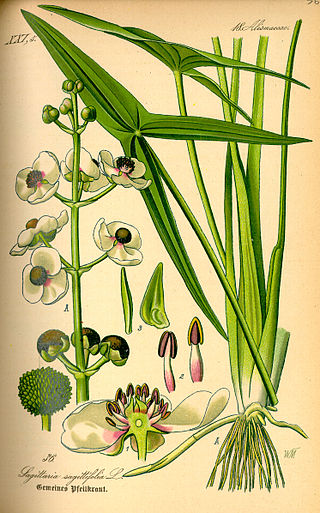
Sagittaria is a genus of about 30 species of aquatic plants whose members go by a variety of common names, including arrowhead, duck potato, katniss, Omodaka, swamp potato, tule potato, and wapato. Most are native to South, Central, and North America, but there are also some from Europe, Africa, and Asia.
Blue Jay is an unincorporated community located in San Bernardino County in California. It is located in the San Bernardino Mountains, above a region of California known as the Inland Empire.
The Arrowhead Trail or Arrowhead Highway was the first all-weather road in the Western United States that connected Los Angeles, California to Salt Lake City, Utah by way of Las Vegas, Nevada. Built primarily during the auto trails period of the 1910s, prior to the establishment of the U.S. numbered highway system, the road was replaced in 1926 by U.S. Route 91 (US 91) and subsequently Interstate 15 (I‑15). Small portions of the route in California and Las Vegas, Las Vegas Boulevard, are sometimes still referred to by the name, or as Arrow Highway.

Arrowhead Regional Medical Center (ARMC) is a teaching hospital located in Colton, California, within Southern California's Inland Empire. ARMC is owned and operated by the County of San Bernardino. The emergency department (ED) at ARMC is the second busiest ED in the state of California. The hospital operates ten different residency training programs.

Lake Arrowhead is an artificial lake located in the San Bernardino Mountains on Little Bear Creek, a tributary of Deep Creek and the Mojave River. It has a surface area of approximately 780 acres (320 ha) and a capacity of 48,000 acre⋅ft (59,000 dam3). It is surrounded by the unincorporated community of Lake Arrowhead in San Bernardino County, California.
Cedar Glen, California is an unincorporated community in located in the San Bernardino National Forest resort area of San Bernardino County immediately east of Lake Arrowhead.

The Morongo Band of Mission Indians is a federally recognized tribe in California, United States. The main tribal groups are Cahuilla and Serrano. Tribal members also include Cupeño, Luiseño, and Chemehuevi Indians. Although many tribes in California are known as Mission Indians, some, such as those at Morongo, were never a part of the Spanish Missions in California.


