
Murrieta Hot Springs is a neighborhood in the eastern region of Murrieta, California, which was annexed on July 1, 2002. Prior to annexation, Murrieta Hot Springs was a Census-designated place of Riverside County, California. The population was 2,948 at the 2000 census.

Crestline is a census-designated place in the San Bernardino Mountains of San Bernardino County, California, USA. The population was 10,770 at the 2010 census, up from 10,218 at the 2000 census.

Calvary Chapel is an international association of charismatic evangelical churches, with origins in Pentecostalism. It maintains a number of radio stations around the world and operates many local Calvary Chapel Bible College programs.

The Transverse Ranges are a group of mountain ranges of southern California, in the Pacific Coast Ranges physiographic region in North America. The Transverse Ranges begin at the southern end of the California Coast Ranges and lie within Santa Barbara, Ventura, Los Angeles, San Bernardino, Riverside and Kern counties. The Peninsular Ranges lie to the south. The name Transverse Ranges is due to their east–west orientation, making them transverse to the general northwest–southeast orientation of most of California's coastal mountains.

San Gorgonio Mountain, also known locally as Mount San Gorgonio, or Old Greyback, is the highest peak in Southern California and the Transverse Ranges at 11,503 feet (3,506 m).

The San Bernardino Mountains are a high and rugged mountain range in Southern California in the United States. Situated north and northeast of San Bernardino and spanning two California counties, the range tops out at 11,503 feet (3,506 m) at San Gorgonio Mountain – the tallest peak in Southern California. The San Bernardinos form a significant region of wilderness and are popular for hiking and skiing.
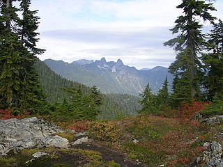
Cypress Provincial Park is a provincial park on the North Shore of Metro Vancouver Regional District, British Columbia. The park has two sections: a 21 km2 (8.1 sq mi) southern section which is accessible by road from West Vancouver, and a 9 km2 (3.5 sq mi) northern section which is only accessible by hiking trails. The two sections are linked by a narrow strip of park along the mountainous Howe Sound Crest Trail.

Mount San Antonio, commonly referred to as Mount Baldy or Old Baldy, is a 10,064 ft (3,068 m) summit in the San Gabriel Mountains on the border of Los Angeles and San Bernardino counties of California. Lying within the San Gabriel Mountains National Monument and Angeles National Forest, it is the high point of the range, the County of Los Angeles, and the Los Angeles metropolitan area.

Greer is an unincorporated community and census-designated place in Apache County, Arizona, United States. Located within the White Mountains of Arizona and surrounded by the Apache-Sitgreaves National Forest, Greer is the highest town in the state at an elevation of approximately 8,400 feet. As of the 2020 census it had a population of 58. Greer was founded circa 1879 by Mormon settlers from Utah. The Greer post office has the ZIP code of 85927.

Angelus Oaks is an unincorporated community in San Bernardino County, California, United States, and has a population of 535 as of the 2010 U.S. Census, up from an estimated population of 312 in 2000. It is surrounded by the San Bernardino National Forest and located east of San Bernardino on California State Route 38.
Oro Grande is an unincorporated community in the Mojave Desert of San Bernardino County, California, United States. It lies on the city boundary of Victorville and Adelanto. It is at 3,000 feet (910 m) elevation in Victor Valley north of the San Bernardino mountain range. It is located on old Route 66 near Interstate 15 between Victorville and Barstow. The ZIP code is 92368 and the community is inside area codes 442 and 760. Less than 1,000 residents live in the unincorporated area.

Banff Sunshine Village is a ski resort in western Canada, located on the Continental Divide of the Canadian Rockies within Banff National Park in Alberta and Mount Assiniboine Provincial Park in British Columbia. It is one of three major ski resorts located in the Banff National Park. Because of its location straddling the Continental Divide, Sunshine receives more snow than the neighbouring ski resorts. The Sunshine base area is located 15 km (9 mi) southwest of the town of Banff. By car, it is about a ninety-minute drive from the city of Calgary; the Sunshine exit on the Trans Canada Highway is 8 km (5 mi) west of the town of Banff.
Calvary Chapel Bible College is an evangelical Christian Biblical studies college located at 26409 CA-189 in Twin Peaks, California. The campus relocated to Murrieta Hot Springs in Murrieta, California from 1994 to Summer 2022. The original Twin Peaks site was converted into a Christian Conference Center. In July 2022, C.C.B.C. returned to the original Twin Peaks site after nearly 30 years away. The conference center was disbanded and merged into the returning Bible College. It was founded as a ministry of Calvary Chapel Costa Mesa and operates on a 15-week spring and fall semester schedule with summer classes and various internships & work-study opportunities.
South Mount Hawkins is located in the San Gabriel Mountains, and contained within the Angeles National Forest. The mountain was named after Nellie Hawkins, a popular waitress of the Squirrel Inn located on the North Fork of the San Gabriel River. Although the Squirrel Inn is long gone, Nellie has her name on Mount Hawkins and South Mount Hawkins. There are two ridge bumps between the two named summits and they are unofficially known as "Middle Hawkins" and "Sadie Hawkins". According to the California State Library, "Cold Brook Camp, located within the Angeles National Forest, [was] very popular with campers. Started out as hunter's camp owned by R.W. Dawson. In 1901, land leased to Doc Beatty who opened hostelry called Squirrel Inn. In 1907, Dawson took over the Inn renaming it Cold Brook Camp. Eventually built hotel, cabins and tents. Was popular in early 1900s and into the 1920s."
Ludlow is an unincorporated community in the Mojave Desert on Interstate 40, located in San Bernardino County, California, United States. The older remains of the ghost town are along historic Route 66.

June Lake is an unincorporated community and census-designated place (CDP) in Mono County, California, United States. It is located against the southern rim of the Mono Basin, 12.5 miles (20 km) south of Lee Vining, at an elevation of 7,654 feet (2,333 m).
Pinecrest is an unincorporated community in the Stanislaus National Forest in Tuolumne County, California, United States. Pinecrest is located near Pinecrest Lake northeast of Mi-Wuk Village. Pinecrest Lake sits in what was once a meadow surrounded by granite outcroppings. Originally, Pinecrest Lake was called Strawberry Flat because of the wild strawberries that once grew there. In the 1960s the name was officially changed to Pinecrest. Pinecrest is a community of USFS Recreation Residences authorized by the United States Forest Service under the Occupancy Permits Act. The campground adjacent to the lake is under the white fir, cedar, and sugar pine trees.

Homewood Mountain Resort is a ski area located on the west shore of Lake Tahoe in the state of California, a few miles south of Tahoe City in the town of Homewood. It has 1,260 acres (510 ha) of skiable terrain and eight lifts. While it currently does not offer lodging on site, a Draft Environmental Impact Statement has been submitted to the regional planning commission to allow for the development of a resort inclusive of a hotel, condominiums, and various other additions. Since 2006, JMA Ventures, a San Francisco Bay Area developer, has owned and operated the ski area.

Forest Falls is an unincorporated community in San Bernardino County, California, 75 miles (121 km) due east of Los Angeles. The community has a population of 1,102 and contains 712 houses. Forest Falls is best known for the waterfalls on Vivian and Falls creeks and as a point of access for recreation in the San Bernardino National Forest, particularly the San Gorgonio Wilderness Area, which lies directly north of the community.
Moose Mountain Upland, Moose Mountain Uplands, or commonly Moose Mountain, is a hilly plateau located in the south-east corner of the Canadian province of Saskatchewan, that covers an area of about 13,000 km2 (5,000 sq mi). The upland rises about 200 m (660 ft) above the broad, flat prairie which is about 600 m (2,000 ft) above sea level. The highest peak is "Moose Mountain" at 830 m (2,720 ft) above sea level. The area was named Moose Mountain because of the large number of moose that lived in the area. When it was originally used by fur traders, Métis, and the Indigenous peoples, the plateau was called Montagne a la Bosse, which is French for "The Mountain of The Bump or Knob."


