
Stovepipe Wells is a way-station in the northern part of Death Valley, in unincorporated Inyo County, California.

Area codes 760 and 442 are telephone area codes in the North American Numbering Plan (NANP) for the U.S. state of California. These area codes serve an overlay numbering plan area (NPA) that comprises much of the southeastern and southernmost portions of California. It includes Imperial, Inyo, and Mono counties, as well as portions of San Diego, Riverside, San Bernardino, Los Angeles and Kern counties. Area code 760 was created on March 22, 1997 in a split of area code 619. Area code 442 was added to the same area on November 21, 2009.

Death Valley Junction, more commonly known as Amargosa, is a tiny Mojave Desert unincorporated community in Inyo County, California, at the intersection of SR 190 and SR 127, in the Amargosa Valley and just east of Death Valley National Park. The zip code is 92328, the elevation is 2,041 ft (622 m), and the population is fewer than four people.

Vidal, California is a small unincorporated community located in southeastern California, in San Bernardino County on U.S. Route 95, 38 miles (61 km) north of Blythe, California, United States and 55 miles (89 km) south of Needles. The town is 22 miles (35 km) west of the townsite of Earp, California and 23 miles (37 km) west of Parker, Arizona on State Highway 62. The community, which is two miles (3 km) north of the Riverside County line, lies at an elevation of 812 feet (247 m) above sea level. Vidal is 221 miles (356 km) from the city of San Bernardino, making it the second-farthest town in the county from the county seat behind Earp. Wyatt Earp spent the last winters of his life in Vidal, working claims of gold and copper he found nearby; the aforementioned townsite of Earp is located in and around those claims.

State Route 89 is a state highway in the U.S. state of California that travels in the north–south direction, serving as a major thoroughfare for many mountain communities in the Sierra Nevada and the Cascade Range. It starts from U.S. Route 395 near Topaz Lake, winding its way up to the 8,314-foot (2,534 m) Monitor Pass, down to the Carson River, and up again over the 7,740-foot (2,359 m) Luther Pass. From that point on, the route generally loses elevation on its way past Lake Tahoe, through Tahoe and Plumas National Forests until Lake Almanor. For roughly nine miles the route is then a part of State Route 36. The route then ascends to the 5,753-foot (1,754 m) Morgan Summit. After it enters Lassen Volcanic National Park it continues to gain elevation until it reaches its highest point in an unnamed pass in the middle of Lassen Peak and Bumpass Mountain. The road then descends and heads northwest, finally terminating at Interstate 5 at the foot of Mount Shasta at around 3,600 feet (1,100 m).

State Route 44 is a state highway in the U.S. State of California that travels in an east–west direction from State Routes 273 and 299 in Redding to Lassen Volcanic National Park before ending at State Route 36 west of Susanville. This final portion, between the park and its terminus, is part of the Volcanic Legacy Scenic Byway, a National Scenic Byway.
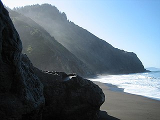
The Lost Coast is a mostly natural and undeveloped area of the California North Coast in Humboldt and Mendocino Counties, which includes the King Range. It was named the "Lost Coast" after the area experienced depopulation in the 1930s. In addition, the steepness and related geotechnical challenges of the coastal mountains made this stretch of coastline too costly for state highway or county road builders to establish routes through the area, leaving it the most undeveloped and remote portion of the California coast. Without any major highways, communities in the Lost Coast region such as Petrolia, Shelter Cove, and Whitethorn are somewhat isolated from the rest of California.

Wheeler Ridge is an unincorporated community in the southwestern San Joaquin Valley, within Kern County, California. It is at the junction of the valley floor and the Wheeler Ridge landform of the Tehachapi Mountains.

Famoso is an unincorporated community in Kern County, California. It is located on Poso Creek 5.5 miles (8.9 km) south-southeast of McFarland, at an elevation of 427 feet (130 m). Famoso is located at the junction of State Route 99 and the eastern terminus of State Route 46. The town is famous for its nut groves and especially the race track - Auto Club Famoso Raceway.
Castaic Junction is an unincorporated community located in Los Angeles County, California. It is located at the crossroads of Interstate 5 and State Route 126 near the confluence of Castaic Creek and the Santa Clara River.

Ocotillo Wells is an unincorporated community in San Diego County, California, United States. It is 3 miles (4.8 km) west of the Imperial County line on California State Route 78 at an elevation of 163 feet (50 m). The name became official in 1962 when it was adopted for federal use by the US Board on Geographic Names. A federally recognized variant name, Ocotillo, can cause confusion with the community of Ocotillo, California in Imperial County, 29 mi (47 km) to the south on Interstate 8.
Alton is an unincorporated community in Humboldt County, California. It is located 3.5 miles (5.6 km) south-southeast of Fortuna, at an elevation of 62 feet. Alton is located along U.S. Route 101 and State Route 36. The ZIP Code is 95540. The community is inside area code 707.
Fernbridge is an unincorporated community at an elevation of 39 feet (12 m) in Humboldt County, California, named for a historic bridge, 3 miles (4.8 km) west-northwest of Fortuna. The bridge is the world's longest poured concrete bridge and was the only bridge on the lower Eel River to survive the mid-century floods.

U.S. Route 395 (US 395) is a United States Numbered Highway, stretching from Hesperia, California to the Canadian border in Laurier, Washington. The California portion of US 395 is a 557-mile (896 km) route which traverses from Interstate 15 (I-15) in Hesperia, north to the Oregon state line in Modoc County near Goose Lake. The route clips into Nevada, serving the cities Carson City and Reno, before returning to California.

Havilah is an unincorporated community in Kern County, California. It is located in the mountains between Walker Basin and the Kern River Valley, 5 miles (8.0 km) south-southwest of Bodfish at an elevation of 3,136 feet (956 m).

U.S. Route 95 (US 95) is a United States Numbered Highway, stretching from the Mexican border in San Luis, Arizona to the Canadian border near Eastport, Idaho. The California portion of US 95 traverses through the far eastern edges of both Riverside and San Bernardino counties. US 95 serves Blythe and Needles and junctions with SR 62 at Vidal Junction.

Vidal Valley is a 20-mile (32 km) long valley in the far eastern Colorado Desert bordering the Colorado River. Most of the valley is in eastern San Bernardino County, California, but the outfall on the Colorado River is in northeast Riverside County. Vidal Valley forms the large border of the south side of the east-west block of the Whipple Mountains massif, the landform that forces the Colorado to flow southeast, then back southwest. The southeast exit of the valley into Parker Valley on the Colorado River skirts the north end of the Riverside Mountains. The Colorado River Aqueduct crosses the midpoint of the valley at Vidal Junction, California. The Vidal Valley also lies due east of the Danby Dry Lake landform.
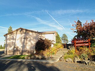
Valleyford is an unincorporated community in Spokane County, Washington, United States. Valleyford has a post office with ZIP code 99036. Valleyford was listed to have a population of 2,913 according to the 2010 United States census.
Cajon Junction is an unincorporated community in Cajon Canyon and the northern Cajon Pass area, within San Bernardino County, California.


