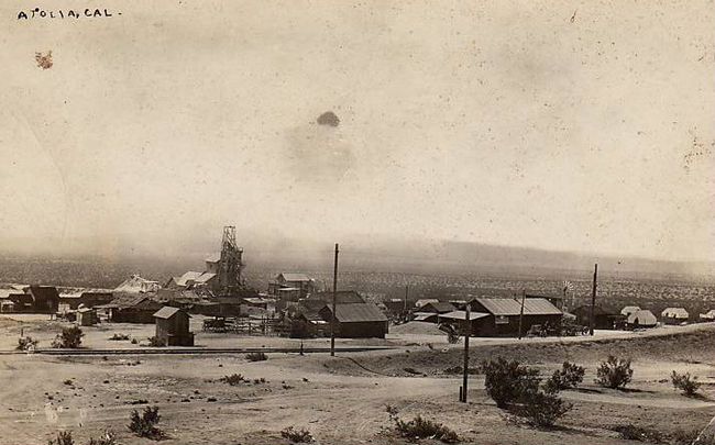
Atolia is a ghost town in the Mojave Desert near Randsburg, in northwestern San Bernardino County, California.
Atolia is a ghost town in the Mojave Desert near Randsburg, in northwestern San Bernardino County, California.
It was at the site of a tungsten mine that started production about 1905. The community was named after two mining company officials, Atkins and DeGolia. At one time there were 2000 people living there.
Atolia was on the Randsburg Railway line. There was once a dairy, a movie theater, and the Bucket of Blood saloon. But, as of 2007 [update] , commercial operations have been abandoned.
35°18′53″N117°36′33″W / 35.31472°N 117.60917°W
| | This San Bernardino County, California–related article is a stub. You can help Wikipedia by expanding it. |
| | This California ghost town-related article is a stub. You can help Wikipedia by expanding it. |

Johannesburg is a census-designated place (CDP) in Kern County, California, in a mining district of the Rand Mountains. Johannesburg is located 1 mile (1.6 km) east-northeast of Randsburg, at an elevation of 3,517 feet (1,072 m). The terminus of the Randsburg Railway was here from 1897 to 1933. The population was 172 at the 2010 census, down from 176 at the 2000 census. Johannesburg is divided from the neighboring community of Randsburg by a ridge. The town is frequently referred to as "Jo-burg" by locals and frequent visitors to the northwest Mojave.

Randsburg is a census-designated place (CDP) in Kern County, California, United States. Randsburg is located 17 miles (27 km) south of Ridgecrest, at an elevation of 3,504 feet (1,068 m). The population was 69 in the 2010 census, down from 77 in the 2000 census.
Cache Creek is an arroyo in the western Tehachapi Pass and Mojave Desert areas of Kern County, southern California.

Garlock is an unincorporated community in Kern County, California, United States. It is located 6.25 miles (10 km) east-southeast of Saltdale, at an elevation of 2,169 feet.

Panamint City is a ghost town in the Panamint Range, near Death Valley, in Inyo County, California, US. It is also known by the official Board of Geographic Names as Panamint. Panamint was a boom town founded after silver and copper were found there in 1872. By 1874, the town had a population of about 2,000. Its main street was one mile (1.6 km) long. Panamint had its own newspaper, the Panamint News. Silver was the principal product mined in the area. The town is located about three miles northwest of Sentinel Peak. According to the National Geographic Names Database, NAD27 latitude and longitude for the locale are 36°07′06″N117°05′43″W, and the feature ID number is 1661185. The elevation of this location is identified as being 6,280 feet AMSL. The similar-sounding Panamint Springs, California, is located about 25.8 miles at 306.4 degrees off true north near Panamint Junction.
The Rand Mountains are located in the Mojave Desert northeast of California City and southwest of the town of Randsburg.
The El Paso Mountains are located in the northern Mojave Desert, in central Southern California in the Western United States.

Tyrone is a ghost town located in Grant County, New Mexico, United States, in the southwestern part of the state.
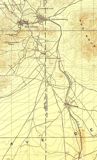
The Randsburg Railway was a 28.5-mile (45.9 km) branch line railroad in California's Mojave Desert. It originated at the main line of the Atchison, Topeka, and Santa Fe Railroad (AT&SF) at Kramer Junction, California, and terminated at Johannesburg, California, with a stop at Atolia. The Railway served as a supply link to the Rand Mine, which produced more silver than any mine in California. The Rand mine closed in 1929, as it was no longer profitable.

Searles Valley Minerals Inc. is a raw materials mining and production company with corporate offices in Overland Park, Kansas. It is owned by the Indian company Nirma. It has major operations in the Searles Valley centered in Trona, California where it is the town's largest employer. The company produces borax, boric acid, soda ash, salt cake, and salt. It also owns the Trona Railway.
KLXP is a non-commercial radio station that is licensed to Randsburg, California and serves Ridgecrest, California City, and the Antelope Valley. The station is owned by Educational Media Foundation and broadcasts the Christian adult contemporary format of its nationally syndicated K-Love network. KLXP is simulcast on translator station K236AW in Lancaster, California.
Quartzburg is a former settlement in Kern County, California. It was located 1 mile (1.6 km) north of the original site of Kernville, now inundated by Isabella Lake, except at low water. In 1873, Quartzburg was founded as a mining camp after gold production increased nearby.

Jardine is an unincorporated village in Park County, Montana, United States. The town lies just to the north of Gardiner on inactive travertine terraces, much like those at Mammoth Hot Springs in nearby Yellowstone National Park. The town's chief industry was a gold mine. The community has the name of A. C. Jardine, a businessperson in the mining industry.
Noonday Camp, also known as Mill City, Noonday City, and Tecopa, is a ghost town located in the Mojave Desert east of Tecopa in Inyo County, California.

Red Mountain, formerly known as Osdick, is an unincorporated community in San Bernardino County, California, United States.
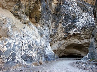
Titus Canyon is a deep, narrow gorge cut into the steep face of the Grapevine Mountains of the Mojave Desert, within Death Valley National Park in southeastern California and southwestern Nevada. The canyon features limestone rock formations, petroglyphs, and native plants and wildlife.
Leon is a ghost town in northern San Diego County, California. A former gold mining town from the 1880s, it was named for the Leon Mine that lay on a hill to the northwest of the town. Leon became part of southwestern Riverside County in 1893. Leon had its own post office from May 4, 1888, until July 31, 1911, when its post office was moved to Perris, California.
San Juan or Upper Camp is a ghost town that was a mining camp of the Eldorado Mining District. It was located in the upper reach of El Dorado Canyon, just below the present day location of Nelson in Clark County, Nevada.
Seventeen Mile Point is a mountain at the north end of the Old Dad Mountains in San Bernardino County, California. Its summit is at an altitude of 2,500 feet / 760 meters.
Hedges, later renamed Tumco, is a locale, a ghost town, site of a former mining town, in Imperial County, California. It lies at an elevation of 617 feet / 188 meters along the Tumco Wash in the Cargo Muchacho Mountains. Nearby is the Hedges Cemetery at an elevation of 643 feet, at 32°53′04″N114°49′52″W.
