Related Research Articles

San Bernardino County, officially the County of San Bernardino, is a county located in the southern portion of the U.S. state of California, and is located within the Inland Empire area. As of the 2020 U.S. Census, the population was 2,181,654, making it the fifth-most populous county in California and the 14th-most populous in the United States. The county seat is San Bernardino.

Adelanto is a city in San Bernardino County, California, United States. It is approximately 9 miles (14 km) northwest of Victorville in the Victor Valley area of the Mojave Desert, in the northern region of the Inland Empire. The population was 38,046 at the 2020 census.

Apple Valley is an incorporated town in the Victor Valley of San Bernardino County, in the U.S. state of California. Its population was 75,791 as of the 2020 United States Census. The town is east of and adjoining to the neighboring cities of Victorville and Hesperia, 35 miles (56 km) south of Barstow, and 49 miles (79 km) north of San Bernardino through the Cajon Pass. It was incorporated on November 14, 1988, and is one of the 22 incorporated municipalities in California that use "town" in their names instead of "city".
Victorville is a city in Victor Valley in San Bernardino County, California. Its population as of the 2020 census was 134,810.

The Mojave River is an intermittent river in the eastern San Bernardino Mountains and the Mojave Desert in San Bernardino County, California, United States. Most of its flow is underground, while its surface channels remain dry most of the time, except for the headwaters and several bedrock gorges in the lower reaches.

Cajon Pass is a mountain pass between the San Bernardino Mountains to the east and the San Gabriel Mountains to the west in Southern California. Created by the movements of the San Andreas Fault, it has an elevation of 3,777 ft (1,151 m). Located in the Mojave Desert, the pass is an important link from the Greater San Bernardino Area to the Victor Valley, and northeast to Las Vegas. The Cajon Pass area is on the Pacific Crest Trail.
Phelan is an unincorporated community and census-designated place in San Bernardino County, California, in the Victor Valley of the Mojave Desert, north of the San Gabriel Mountains. The population was 14,304 in the 2010 census.
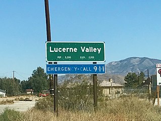
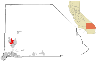
Lucerne Valley is a census-designated place (CDP) and valley landform in the southern Mojave Desert, in western San Bernardino County, California.

Located in Los Angeles County, California's San Gabriel Valley, the Boy Scouts of America's San Gabriel Valley Council (#40) was one of five councils serving Los Angeles County. It was headquartered in Pasadena.
Oro Grande is an unincorporated community in the Mojave Desert of San Bernardino County, California, United States. It lies on the city boundary of Victorville and Adelanto. It is at 3,000 feet (910 m) elevation in Victor Valley north of the San Bernardino mountain range. It is located on old Route 66 near Interstate 15 between Victorville and Barstow. The ZIP code is 92368 and the community is inside area codes 442 and 760. Less than 1,000 residents live in the unincorporated area.
Mojave Heights is an unincorporated community in the Victor Valley of the Mojave Desert, within San Bernardino County, California.

The Diocese of San Bernardino is a Latin Church ecclesiastical territory, or diocese, in Southern California in the United States. Erected by Pope Paul VI on July 14, 1978, its jurisdiction extends over San Bernardino and Riverside counties. As of 2021, the diocese has 92 parishes and 12 missions in its territory. Its cathedral is Our Lady of the Rosary Cathedral in San Bernardino.
California's 23rd congressional district is a congressional district in the U.S. state of California. The district is represented in the 118th United States Congress by Jay Obernolte.
Desert Valley Hospital (DVH) is an 148-bed osteopathic acute care facility in the city of Victorville, San Bernardino County, California. It serves the Victor Valley region of the south−central Mojave Desert.

High Desert is a vernacular region with non-discrete boundaries applying to areas of the western Mojave Desert in southern California. The "High Desert" region is an area that generally is situated between 2,000 feet (610 m) and 4,000 feet (1,200 m) in elevation, and located just north of the San Gabriel, San Bernardino, and Little San Bernardino Mountains.

Murray's Ranch, sometimes called the Overall Wearing Dude Ranch, was a guest ranch in Bell Mountain, California from the 1920s until the 1960s. The ranch was located at the northwest corner of Waalew Road and Dale Evans Parkway in Apple Valley, just outside the city limits of Victorville. It was owned by African Americans and catered primarily to an African American clientele. It also served as the set for a number of "all-black cast" western movies including groundbreaking Western musical Harlem on the Prairie (1937).
Chaparral High School is a public high school in the community of Phelan in the Victor Valley of the Mojave Desert, located in San Bernardino County, California.

Victorville Army Airfield auxiliary fields were four airfields used during World War II to support the Victorville Army Airfield pilot training near Victorville, California, and Adelanto, California. After the war the Victorville Army Airfield was renamed George Air Force Base on January 13, 1948. The airfields were built in 1941 by the United States Army Air Corps just before the war. Victorville Army Airfield covered 2,200-acre in the Mojave Desert. The US Army held a groundbreaking ceremony on 12 July 1941. The base, called Victorville Army Flying School, was ready to use before the attack on Pearl Harbor on December 7, 1941. The Army built four runways in a triangle configuration, with one runway down the middle of the triangle. Seven hangars were built to support operation. On April 23, 1943, the base was renamed Victorville Army Airfield.
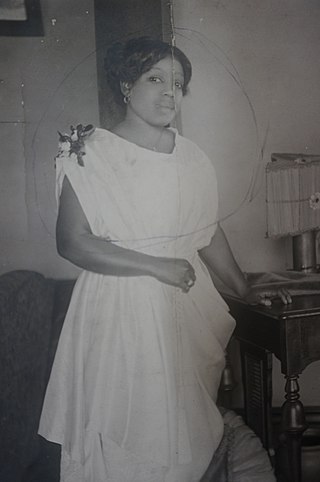
Lela Murray was a prominent black businesswoman, community leader, and advocate for civil rights in Los Angeles during the first half of the 20th century. She co-founded Murray's Ranch, billed by the press as "the only Negro dude ranch in the world," in Bell Mountain, California, providing a place of recreation and leisure to people of color during a period of racial segregation and anti-black sentiment in the United States.
References
- 1 2 Durham, David L. (1998). California's Geographic Names: A Gazetteer of Historic and Modern Names of the State. Quill Driver Books. p. 1394. ISBN 978-1-884995-14-9.
- ↑ Thornton, Jennifer (2018). Remembering Bell Mountain: African American Landownership and Leisure in California's High Desert During the Jim Crow Era. University of California Riverside: ProQuest LLC.

34°37′27″N117°12′25″W / 34.62417°N 117.20694°W
| | This San Bernardino County, California–related article is a stub. You can help Wikipedia by expanding it. |