Calico is a ghost town and former mining town in San Bernardino County, California, United States. Located in the Calico Mountains of the Mojave Desert region of Southern California, it was founded in 1881 as a silver mining town, and was later converted into a county park named Calico Ghost Town. Located off Interstate 15, it lies 3 miles (4.8 km) from Barstow and 3 miles from Yermo. Giant letters spelling CALICO are visible, from the highway, on the Calico Peaks behind it. Walter Knott purchased Calico in the 1950s, and architecturally restored all but the five remaining original buildings to look as they did in the 1880s. Calico received California Historical Landmark #782, and in 2005 was proclaimed by then-Governor Arnold Schwarzenegger to be California's Silver Rush Ghost Town.

Goldfield is an unincorporated small desert city and the county seat of Esmeralda County, Nevada.

Rhyolite is a ghost town in Nye County, in the U.S. state of Nevada. It is in the Bullfrog Hills, about 120 miles (190 km) northwest of Las Vegas, near the eastern boundary of Death Valley National Park. The town began in early 1905 as one of several mining camps that sprang up after a prospecting discovery in the surrounding hills. During an ensuing gold rush, thousands of gold-seekers, developers, miners and service providers flocked to the Bullfrog Mining District. Many settled in Rhyolite, which lay in a sheltered desert basin near the region's biggest producer, the Montgomery Shoshone Mine.

The Otago Gold Rush was a gold rush that occurred during the 1860s in Central Otago, New Zealand. This was the country's biggest gold strike, and led to a rapid influx of foreign miners to the area – many of them veterans of other hunts for the precious metal in California and Victoria, Australia.
Bagdad is a ghost town in the Mojave Desert, in San Bernardino County, California.
Oro Grande is an unincorporated community in the Mojave Desert of San Bernardino County, California, United States. It lies on the city boundary of Victorville and Adelanto. It is at 3,000 feet (910 m) elevation in Victor Valley north of the San Bernardino mountain range. It is located on old Route 66 near Interstate 15 between Victorville and Barstow. The ZIP code is 92368 and the community is inside area codes 442 and 760. Less than 1,000 residents live in the unincorporated area.

The Castle Mountains are located in the Eastern Mojave Desert, in northeastern San Bernardino County, California and Clark County, Nevada. The range lies south and east of the New York Mountains, southwest of Searchlight and west of Cal-Nev-Ari, Nevada.

The Borate and Daggett Railroad was a 3 ft narrow gauge railroad built to carry borax in the Mojave Desert. The railroad ran about 11 miles (18 km) from Daggett, California, US, to the mining camp of Borate, three miles (4.8 km) to the east of Calico.

Gold Point, Nevada is a well-preserved historic mining town in Esmeralda County, Nevada. The community was named after the local gold-mining industry. Gold Point is the southern terminus of Nevada State Route 774. Its current population is about seven.
Ludlow is an unincorporated community in the Mojave Desert on Interstate 40, located in San Bernardino County, California, United States. The older remains of the ghost town are along historic Route 66.
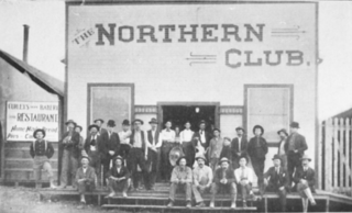
Vanderbilt was a short-lived gold mining town located in San Bernardino County, California, United States. It existed between 1893 and 1895. At its peak it may have had a population of about 400 people.

Ivanpah was a short-lived silver mining town located in San Bernardino County, California, United States. It was founded in 1869 and existed until at least the mid-1880s.
Providence was a short-lived silver mining town located in San Bernardino County, California, United States. It existed between 1880 and 1886.
Belleville, California was a gold mining boomtown in the San Bernardino Mountains of San Bernardino County, California. The settlement grew up rapidly following the discovery of gold by William F. Holcomb in Holcomb Valley early 1860. Which helped the town challenge the seat of San Bernardino County. Belleville was named after Belle, the first child born in the new town. It was a busy mining town for ten years, it was virtually abandoned before the end of the 19th century. It is now a ghost town.

The Waterloo Mining Railroad, also known as the Calico Railroad or Daggett-Calico Railroad, was a 3 ft narrow gauge railroad built to carry silver ore from the mines in the Calico Mountains north of Calico to the mills located at Elephant Mountain near Daggett, California, from 1888 to 1903.
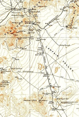
Barnwell, originally a rail camp named Summit, then Manvel, was a former railhead serving local mining camps, now a ghost town, in San Bernardino County, California. It lies at an elevation 4806 feet in the New York Mountains.
California Eastern Railway, is a defunct 45-mile (72 km) short-line railroad that operated from 1902 - 1911. The railroad ran from Goffs, California, to Ivanpah. It was first a private line operated by a mining company, that was acquired by the Atchison, Topeka and Santa Fe Railway.
Castle Mountains National Monument is a U.S. National Monument located in the eastern Mojave Desert and northeastern San Bernardino County, in the state of California.

The Yellow Mountain is a 1954 American Western film directed by Jesse Hibbs and starring Lex Barker, Mala Powers and Howard Duff.