Crestline, California

Last updated

Crestline
San Bernardino County California Incorporated and Unincorporated areas Crestline Highlighted.svg
Location in San Bernardino County and the state of California
Usa edcp location map.svg
Red pog.svg
Crestline
Location in the United States
Coordinates: 34°14′31″N117°17′08″W / 34.24194°N 117.28556°W / 34.24194; -117.28556 [1]
Country Flag of the United States (23px).png  United States
State Flag of California.svg  California
County San Bernardino
Area
[2]
  Total14.02 sq mi (36.32 km2)
  Land13.90 sq mi (36.01 km2)
  Water0.12 sq mi (0.31 km2)  1.00%
Elevation
[1]
4,613 ft (1,406 m)
Population
 (2020)
  Total11,650
  Density837.89/sq mi (323.50/km2)
Time zone UTC-8 (PST)
  Summer (DST) UTC-7 (PDT)
ZIP code
92325
Area code 909
FIPS code 06-17162
GNIS feature ID 1660523

Crestline is a census-designated place in the San Bernardino Mountains of San Bernardino County, California, USA. The population was 10,770 at the 2010 census, up from 10,218 at the 2000 census.

Contents

Geography

Crestline is located at 34°14′33″N117°17′24″W / 34.24250°N 117.29000°W / 34.24250; -117.29000 . [3]

According to the United States Census Bureau, Crestline has a total area of 14.0 square miles (36 km2). 13.8 square miles (36 km2) of it is land and 0.1 square miles (0.26 km2) of it (1.00%) is water.

Crestline is located within the San Bernardino National Forest; Lake Gregory is located in the center of Crestline.

Climate

According to the Köppen Climate Classification system, Crestline has a warm-summer Mediterranean climate, abbreviated Csb on climate maps. [4]

Climate data for Crestline, California
MonthJanFebMarAprMayJunJulAugSepOctNovDecYear
Mean daily maximum °F (°C)45
(7)
47
(8)
51
(11)
56
(13)
64
(18)
74
(23)
81
(27)
80
(27)
76
(24)
64
(18)
55
(13)
47
(8)
62
(17)
Mean daily minimum °F (°C)28
(−2)
29
(−2)
32
(0)
34
(1)
40
(4)
47
(8)
53
(12)
52
(11)
49
(9)
42
(6)
35
(2)
29
(−2)
40
(4)
Average precipitation inches (mm)6.5
(170)
7.6
(190)
6.1
(150)
3.8
(97)
1.4
(36)
0.2
(5.1)
0
(0)
0.2
(5.1)
0.8
(20)
2
(51)
3
(76)
5.9
(150)
37.5
(950)
Average snowfall inches (cm)5.5
(14)
9.4
(24)
7.1
(18)
2.5
(6.4)
0.1
(0.25)
0.0
(0.0)
0.0
(0.0)
0.0
(0.0)
0.1
(0.25)
0.0
(0.0)
1.5
(3.8)
5.4
(14)
31.6
(80.7)
Source: Weatherbase [5]

People

Historical population
CensusPop.Note
2020 11,650
U.S. Decennial Census [6]

2010

At the 2010 census Crestline had a population of 10,770. The population density was 770.4 inhabitants per square mile (297.5/km2). The racial makeup of Crestline was 9,289 (86.2%) White (77.0% Non-Hispanic White), [7] 107 (1.0%) African American, 135 (1.3%) Native American, 96 (0.9%) Asian, 20 (0.2%) Pacific Islander, 526 (4.9%) from other races, and 597 (5.5%) from two or more races. Hispanic or Latino of any race were 1,775 persons (16.5%). [8]

The census reported that 10,723 people (99.6% of the population) lived in households, 39 (0.4%) lived in non-institutionalized group quarters, and 8 (0.1%) were institutionalized.

There were 4,360 households, 1,286 (29.5%) had children under the age of 18 living in them, 2,108 (48.3%) were opposite-sex married couples living together, 451 (10.3%) had a female householder with no husband present, 247 (5.7%) had a male householder with no wife present. There were 309 (7.1%) unmarried opposite-sex partnerships, and 57 (1.3%) same-sex married couples or partnerships. 1,190 households (27.3%) were one person and 362 (8.3%) had someone living alone who was 65 or older. The average household size was 2.46. There were 2,806 families (64.4% of households); the average family size was 2.97.

The age distribution was 2,375 people (22.1%) under the age of 18, 875 people (8.1%) aged 18 to 24, 2,383 people (22.1%) aged 25 to 44, 3,838 people (35.6%) aged 45 to 64, and 1,299 people (12.1%) who were 65 or older. The median age was 43.3 years. For every 100 females, there were 103.2 males. For every 100 females age 18 and over, there were 103.5 males.

There were 7,333 housing units at an average density of 524.6 per square mile, of the occupied units 3,123 (71.6%) were owner-occupied and 1,237 (28.4%) were rented. The homeowner vacancy rate was 6.7%; the rental vacancy rate was 13.8%. 7,463 people (69.3% of the population) lived in owner-occupied housing units and 3,260 people (30.3%) lived in rental housing units.

According to the 2010 United States Census, Crestline had a median household income of $50,079, with 16.8% of the population living below the federal poverty line. [7]

2000

Lake Gregory Lake Gregory.JPG
Lake Gregory

At the 2000 census there were 10,218 people, 4,000 households, and 2,767 families in the CDP. The population density was 940.4 inhabitants per square mile (363.1/km2). There were 6,695 housing units at an average density of 616.2 per square mile (237.9/km2). The racial makeup of the CDP was 88.0% White, 0.8% African American, 1.1% Native American, 0.6% Asian, 0.2% Pacific Islander, 5.0% from other races, and 4.3% from two or more races. Hispanic or Latino of any race were 10.5%. [9]

Of the 4,000 households 33.4% had children under the age of 18 living with them, 53.0% were married couples living together, 10.6% had a female householder with no husband present, and 30.8% were non-families. 24.7% of households were one person and 6.6% were one person aged 65 or older. The average household size was 2.6 and the average family size was 3.0.

The age distribution was 27.8% under the age of 18, 6.3% from 18 to 24, 27.7% from 25 to 44, 29.1% from 45 to 64, and 9.1% 65 or older. The median age was 39 years. For every 100 females, there were 100.6 males. For every 100 females age 18 and over, there were 97.0 males.

The median household income was $44,257 and the median family income was $51,655. Males had a median income of $48,772 versus $28,750 for females. The per capita income for the CDP was $20,987. About 6.6% of families and 8.9% of the population were below the poverty line, including 10.7% of those under age 18 and 4.8% of those age 65 or over.

Government

In the California State Legislature, Crestline is in the 23rd Senate District , represented by Republican Rosilicie Ochoa Bogh, and in the 33rd Assembly District , represented by Republican Devon Mathis. [10]

In the United States House of Representatives, Crestline is in California’s 23rd Congressional District, respresented by Republican Jay Obernolte.

Education

Crestline Community is served by the Rim of the World Unified School District. It includes three (K-5) elementary schools (Valley of Enchantment, Charles Hoffman, Lake Arrowhead), one (6-8) intermediate school (Mary Putnam Henck), and two high schools (Mountain, Rim Of The World Senior). Calvary Chapel Bible College is also located in nearby Twin Peaks.

Neighborhoods in Crestline

The greater community of Crestline includes the neighborhoods known as Valley of Enchantment, Valley of the Moon, Cedarpines Park, and Twin Peaks.

Notable residents

Related Research Articles

<span class="mw-page-title-main">Meridianville, Alabama</span> Census-designated place in Alabama, United States

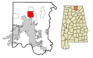
Meridianville is an unincorporated community and census-designated place (CDP) in Madison County, Alabama, United States, and is included in the Huntsville-Decatur Combined Statistical Area. As of the 2020 census, the population of the CDP was 8,209.

<span class="mw-page-title-main">Fairview, California</span> CDP in California, United States

Fairview is a census-designated place (CDP) in Alameda County, California, United States. It borders on the city of Hayward and the census-designated place of Castro Valley. The population was 11,341 at the 2020 census.

<span class="mw-page-title-main">Mesa, California</span> Census-designated place in California, United States

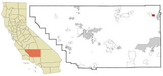
Mesa is a census-designated place (CDP) in Inyo County, California, United States. The population was 251 at the 2010 census, up from 214 at the 2000 census.

<span class="mw-page-title-main">Tamalpais-Homestead Valley, California</span> Census-designated place in California, United States

Tamalpais-Homestead Valley is a census-designated place (CDP) in Marin County, California, United States. The population was 11,492 at the 2020 census.

<span class="mw-page-title-main">East Shore, California</span> Census-designated place in California, United States

East Shore is a census-designated place (CDP) in Plumas County, California, United States. The population was 156 at the 2010 census, down from 177 at the 2000 census.

<span class="mw-page-title-main">Greenhorn, California</span> Census-designated place in California, United States

Greenhorn is a census-designated place (CDP) in Plumas County, California, United States. The population was 236 at the 2010 census, up from 146 at the 2000 census.

<span class="mw-page-title-main">Keddie, California</span> Census-designated place in California, United States

Keddie is a census-designated place in Plumas County, California, United States. The population was 66 at the 2010 census.

<span class="mw-page-title-main">Camp Pendleton South, California</span> Census-designated place in California, United States

Camp Pendleton South is a census-designated place (CDP) in San Diego County, California, located at the southwest corner of the Marine Corps Base Camp Pendleton. The population was 10,616 at the 2010 census, up from 8,854 at the 2000 census. Much of the population are residents of Camp Pendleton barracks situated in the area, as well as housing communities for married Marine and Navy personnel and their families. It, along with Camp Pendleton Mainside CDP, is one of two CDPs on the base.

<span class="mw-page-title-main">La Presa, California</span> Census-designated place in California, United States

La Presa is a census-designated place (CDP) in the East County region of San Diego County, California, United States. The population was 34,169 at the 2010 census, up from 32,721 at the 2000 census.

<span class="mw-page-title-main">China Lake Acres, California</span> Census-designated place in California, United States

China Lake Acres is a census-designated place (CDP) in Kern County, California, United States. The population was 1,876 at the 2010 census, up from 1,761 at the 2000 census.

<span class="mw-page-title-main">Woodbridge (CDP), New Jersey</span> Populated place in Middlesex County, New Jersey, US

Woodbridge is an unincorporated community and census-designated place (CDP) within Woodbridge Township, in Middlesex County, in the U.S. state of New Jersey. As of the 2010 United States Census, the CDP's population was 19,265. Despite the similarity in the name of the CDP and the township, the two are not coextensive; the CDP occupies 15.7% of the township's 24.51 square miles (63.5 km2).

<span class="mw-page-title-main">Allenwood, New Jersey</span> Populated place in Monmouth County, New Jersey, US

Allenwood is an unincorporated community and census-designated place (CDP) located within Wall Township, in Monmouth County, in the U.S. state of New Jersey. As of the 2010 United States Census, the CDP's population was 925.

<span class="mw-page-title-main">Yorketown, New Jersey</span> Populated place in Monmouth County, New Jersey, US

Yorketown is an unincorporated community and census-designated place (CDP) within Manalapan Township, in Monmouth County, in the U.S. state of New Jersey. At the 2020 census, the CDP's population was 6,739.

<span class="mw-page-title-main">Vista Center, New Jersey</span> Populated place in Ocean County, New Jersey, US

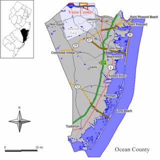
Vista Center is an unincorporated community and census-designated place (CDP) located within Jackson Township in Ocean County, in the U.S. state of New Jersey. As of the 2010 United States Census, the CDP's population was 3,689.

<span class="mw-page-title-main">Groesbeck, Ohio</span> Census-designated place in Ohio, United States

Groesbeck is a census-designated place (CDP) in Hamilton County, Ohio, United States. The population was 7,365 at the 2020 census. It is a suburb of Cincinnati.

<span class="mw-page-title-main">Northbrook, Ohio</span> Census-designated place in Ohio, United States

Northbrook is a census-designated place (CDP) in Hamilton County, Ohio, United States. The population was 10,912 at the 2020 census.

<span class="mw-page-title-main">Northgate, Ohio</span> Census-designated place in Ohio, United States

Northgate is a census-designated place (CDP) in Colerain Township, Hamilton County, Ohio, United States. The population was 7,277 at the 2020 census.

<span class="mw-page-title-main">Glide, Oregon</span> Census-designated place in Oregon, United States

Glide is a census-designated place (CDP) in Douglas County, Oregon, United States. The population was 1,795 at the 2010 census.

<span class="mw-page-title-main">Berea, South Carolina</span> CDP in South Carolina, United States

Berea is a census-designated place (CDP) in Greenville County, South Carolina, United States. The population was 14,295 at the 2010 census. It is part of the Greenville–Mauldin–Easley Metropolitan Statistical Area.

<span class="mw-page-title-main">Windsor, Wisconsin</span> Village in Wisconsin, United States

Windsor is a village and former town in Dane County, Wisconsin. The population was 8,754 at the time of the 2020 census. The communities of Lake Windsor, Morrisonville, and Token Creek are located within the village. Windsor voted to incorporate as a village on November 3, 2015; prior to its incorporation, it was a town, and a portion of the town was a census-designated place. Windsor is a part of the Census Bureau's Madison metropolitan statistical area.

References

  1. 1 2 "Crestline". Geographic Names Information System . United States Geological Survey, United States Department of the Interior . Retrieved November 12, 2014.
  2. "2020 U.S. Gazetteer Files". United States Census Bureau. Retrieved October 30, 2021.
  3. "US Gazetteer files: 2010, 2000, and 1990". United States Census Bureau. February 12, 2011. Retrieved April 23, 2011.
  4. Climate Summary for Crestline, California
  5. "Weatherbase.com". Weatherbase. 2013. Retrieved on October 13, 2013.
  6. "Census of Population and Housing". Census.gov. Retrieved June 4, 2016.
  7. 1 2 "Crestline CDP QuickFacts from the US Census Bureau". Archived from the original on July 2, 2012. Retrieved December 26, 2013.
  8. "2010 Census Interactive Population Search: CA - Crestline CDP". U.S. Census Bureau. Archived from the original on July 15, 2014. Retrieved July 12, 2014.
  9. "U.S. Census website". United States Census Bureau . Retrieved January 31, 2008.
  10. "Statewide Database". UC Regents. Archived from the original on February 1, 2015. Retrieved December 8, 2014.