
Houston Street is a major east–west thoroughfare in Lower Manhattan in New York City, United States. It runs the full width of the island of Manhattan, from FDR Drive along the East River in the east to the West Side Highway along the Hudson River in the west. The street is divided into west and east sections by Broadway.

Manhattan's Chinatown is a neighborhood in Lower Manhattan, New York City, bordering the Lower East Side to its east, Little Italy to its north, Civic Center to its south, and Tribeca to its west. With an estimated population of 90,000 to 100,000 people, Chinatown is home to the highest concentration of Chinese people in the Western Hemisphere. Manhattan's Chinatown is also one of the oldest Chinese ethnic enclaves. The Manhattan Chinatown is one of nine Chinatown neighborhoods in New York City, as well as one of twelve in the New York metropolitan area, which contains the largest ethnic Chinese population outside of Asia, comprising an estimated 893,697 uniracial individuals as of 2017.

The Lower East Side, sometimes abbreviated as LES, is a historic neighborhood in the southeastern part of Manhattan in New York City. It is located roughly between the Bowery and the East River from Canal to Houston streets. Historically, it was understood to encompass a much larger area, from Broadway to the East River and from East 14th Street to Fulton and Franklin Streets.
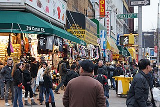
Canal Street is a major east–west street of over 1 mile (1.6 km) in Lower Manhattan, New York City, United States, running from East Broadway between Essex and Jefferson Streets in the east, to West Street between Watts and Spring Streets in the west. It runs through the neighborhood of Chinatown, and forms the southern boundaries of SoHo and Little Italy as well as the northern boundary of Tribeca. The street acts as a major connector between Jersey City, New Jersey, via the Holland Tunnel (I-78), and Brooklyn in New York City via the Manhattan Bridge. It is a two-way street for most of its length, with two unidirectional stretches between Forsyth Street and the Manhattan Bridge.

Avenue D is the easternmost named avenue in the East Village neighborhood of Manhattan, New York City, east of Avenue C and west of the FDR Drive. It runs through East 13th and Houston Streets, and continues south of Houston Street as Columbia Street until Delancey Street and Abraham E. Kazan Street until its end at Grand Street. Avenues A, B, C and D are the origin of the name of the section of the East Village neighborhood through which they run, Alphabet City.
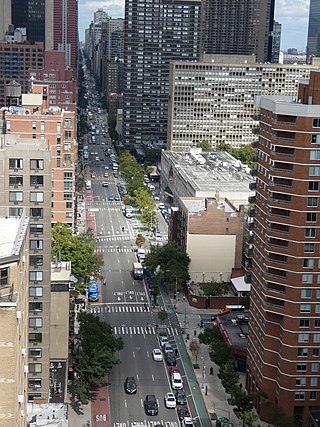
Second Avenue is located on the East Side of the New York City borough of Manhattan extending from Houston Street at its south end to the Harlem River Drive at 128th Street at its north end. A one-way street, vehicular traffic on Second Avenue runs southbound (downtown) only, except for a one-block segment of the avenue in Harlem. South of Houston Street, the roadway continues as Chrystie Street south to Canal Street.

The 23rd Street Crosstown is a surface transit line on 23rd Street in Manhattan, New York City. It currently hosts the M23 SBS bus route of the Metropolitan Transportation Authority (MTA)'s Regional Bus Operations. The M23 runs between Chelsea Piers, along the West Side Highway near 22nd Street, via 23rd Street, to Avenue C and 20th Street in Stuyvesant Town–Peter Cooper Village.

First Avenue is a north-south thoroughfare on the East Side of the New York City borough of Manhattan, running from Houston Street northbound to 127th Street. At 125th Street, most traffic continues onto the Willis Avenue Bridge over the Harlem River, which continues into the Bronx. South of Houston Street, the roadway continues as Allen Street south to Division Street. Traffic on First Avenue runs northbound (uptown) only.

Franklin D. Roosevelt East River Drive, commonly called FDR Drive for short, is a 9.68-mile (15.58 km) parkway on the east side of the New York City borough of Manhattan. It starts near South and Broad Streets, just north of the Battery Park Underpass, and runs north along the East River to the 125th Street / Robert F. Kennedy Bridge / Willis Avenue Bridge interchange, where it becomes Harlem River Drive. All of FDR Drive is designated New York State Route 907L (NY 907L), an unsigned reference route.

Chatham Square is a major intersection in Chinatown, Manhattan, New York City. The square lies at the confluence of eight streets: the Bowery, Doyers Street, East Broadway, St. James Place, Mott Street, Oliver Street, Worth Street and Park Row. The small park in the center of the square is known as Kimlau Square and Lin Ze Xu Square.

New York State Route 1A (NY 1A) was a north–south state highway mostly located within New York City. It extended for just under 18 miles (29 km) from an intersection with NY 27 near the Holland Tunnel in Lower Manhattan to an interchange with U.S. Route 1 (US 1) just north of the New York City line in the Westchester County village of Pelham Manor. In Manhattan and the South Bronx, NY 1A used several surface streets to traverse the boroughs, including a handful of one-way roads. At the Bronx River, it began to follow limited-access highways, specifically the Bruckner Expressway and the Hutchinson River Parkway.

The Second Avenue station is a station on the IND Sixth Avenue Line of the New York City Subway, located at the intersection of Second Avenue and Houston Street on the border between the East Village and the Lower East Side, in Manhattan. It is served by the F train at all times and the <F> train during rush hours in the peak direction.

Maryland Route 140 is a 49-mile (79 km) state highway in the U.S. state of Maryland. The route runs from U.S. Route 1 and US 40 Truck in Baltimore northwest to the Pennsylvania border, where the road continues into that state as Pennsylvania Route 16. MD 140 passes through the northern part of central Maryland, connecting Baltimore, Pikesville, Reisterstown, Westminster, Taneytown, and Emmitsburg.
The First and Second Avenues Line, also known as the Second Avenue Line, is a bus line in Manhattan, New York City, running mostly along Second Avenue from Lower Manhattan to East Harlem. Originally a streetcar line along Second Avenue, it is now the M15 bus route, the busiest bus route in the city and United States, carrying over 9.6 million people annually. MTA Regional Bus Operations, under the New York City Bus and Select Bus Service brands, operates the local out of the Tuskegee Airmen Bus Depot and the SBS from the Mother Clara Hale Bus Depot. Service is operated exclusively with articulated buses.

West Broadway is a north-south street in the New York City borough of Manhattan, separated into two parts by Tribeca Park. The northern part begins at Tribeca Park, near the intersection of Avenue of the Americas, Walker Street and Beach Street in Tribeca. It runs northbound as a one-way street past Canal Street and becomes two-way at the intersection with Grand Street one block farther north. West Broadway then operates as a main north-south thoroughfare through SoHo until its northern end at Houston Street, on the border between SoHo and Greenwich Village. North of Houston Street, it is designated as LaGuardia Place, which continues until Washington Square South.

Essex Street is a north-south street on the Lower East Side of the New York City borough of Manhattan. North of Houston Street, the street becomes Avenue A, which goes north to 14th Street. South of Canal Street it becomes Rutgers Street, the southern end of which is at South Street.

Division Street is a one-way street in the Two Bridges neighborhood of Lower Manhattan in New York City. It carries westbound traffic from the intersection of Canal Street and Ludlow Street westward to Bowery.

Madison Street is a two-way thoroughfare in the Lower East Side of the New York City borough of Manhattan that begins under the Brooklyn Bridge entrance ramp and ends at Grand Street. It is roughly sixteen large city blocks long. Due to security measures implemented after the September 11 attacks, public access to the part of the street before St. James Place is restricted.

East Broadway is a two-way east–west street in the Chinatown, Two Bridges, and Lower East Side neighborhoods of the New York City borough of Manhattan in the U.S. state of New York.


