
Broadway is a road in the U.S. state of New York. Broadway runs from State Street at Bowling Green for 13 mi (20.9 km) through the borough of Manhattan and 2 mi (3.2 km) through the Bronx, exiting north from New York City to run an additional 18 mi (29.0 km) through the Westchester County municipalities of Yonkers, Hastings-On-Hudson, Dobbs Ferry, Irvington, and Tarrytown, and terminating north of Sleepy Hollow.

Manhattan's Chinatown is a neighborhood in Lower Manhattan, New York City, bordering the Lower East Side to its east, Little Italy to its north, Civic Center to its south, and Tribeca to its west. With an estimated population of 90,000 to 100,000 people, Chinatown is home to the highest concentration of Chinese people in the Western Hemisphere. Manhattan's Chinatown is also one of the oldest Chinese ethnic enclaves. The Manhattan Chinatown is one of nine Chinatown neighborhoods in New York City, as well as one of twelve in the New York metropolitan area, which contains the largest ethnic Chinese population outside of Asia, comprising an estimated 893,697 uniracial individuals as of 2017.

The Lower East Side, sometimes abbreviated as LES, is a historic neighborhood in the southeastern part of Manhattan in New York City. It is located roughly between the Bowery and the East River from Canal to Houston streets. Historically, it was understood to encompass a much larger area, from Broadway to the East River and from East 14th Street to Fulton and Franklin Streets.

The Manhattan Bridge is a suspension bridge that crosses the East River in New York City, connecting Lower Manhattan at Canal Street with Downtown Brooklyn at the Flatbush Avenue Extension. The main span is 1,480 ft (451 m) long, with the suspension cables being 3,224 ft (983 m) long. The bridge's total length is 6,855 ft (2,089 m). It is one of four toll-free vehicular bridges connecting Manhattan Island to Long Island; the nearby Brooklyn Bridge is just slightly further west, while the Queensboro and Williamsburg bridges are to the north.
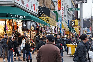
Canal Street is a major east–west street of over 1 mile (1.6 km) in Lower Manhattan, New York City, United States, running from East Broadway between Essex and Jefferson Streets in the east, to West Street between Watts and Spring Streets in the west. It runs through the neighborhood of Chinatown, and forms the southern boundaries of SoHo and Little Italy as well as the northern boundary of Tribeca. The street acts as a major connector between Jersey City, New Jersey, via the Holland Tunnel (I-78), and Brooklyn in New York City via the Manhattan Bridge. It is a two-way street for most of its length, with two unidirectional stretches between Forsyth Street and the Manhattan Bridge.

Delancey Street is one of the main thoroughfares of New York City's Lower East Side in Manhattan, running from the street's western terminus at the Bowery to its eastern end at FDR Drive, connecting to the Williamsburg Bridge and Brooklyn at Clinton Street. It is an eight-lane, median-divided street west of Clinton Street, and a service road for the Williamsburg Bridge east of Clinton Street. West of Bowery, Delancey Street becomes Kenmare Street, which continues as a four-lane, undivided street to Lafayette Street.

Forsyth Street runs from Houston Street south to Henry Street in the New York City borough of Manhattan. The street was named in 1817 for Lt. Colonel Benjamin Forsyth.

Rivington Street is a street in the New York City borough of Manhattan, which runs across the Lower East Side neighborhood, between the Bowery and Pitt Street, with a break between Chrystie and Forsyth for Sara D. Roosevelt Park. Vehicular traffic runs west on this one-way street.
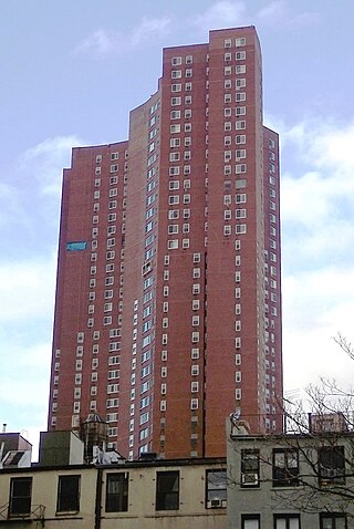
Confucius Plaza Apartments is a limited-equity housing cooperative in Chinatown, Manhattan, New York City. The 44-story brown brick tower block complex with 762 apartments was constructed in 1975 at a cost of $38.387 million. The building was the first major public-funded housing project built for almost exclusively Chinese Americans.

The Manhattan Waterfront Greenway is a waterfront greenway for walking or cycling, 32 miles (51 km) long, around the island of Manhattan, in New York City. The largest portions are operated by the New York City Department of Parks and Recreation. It is separated from motor traffic, and many sections also separate pedestrians from cyclists. There are three principal parts — the East, Harlem and Hudson River Greenways.

Chambers Street is a two-way street in the New York City borough of Manhattan. It runs from River Terrace, Battery Park City in the west, past PS 234, The Borough of Manhattan Community College, and Stuyvesant High School, to the Manhattan Municipal Building at 1 Centre Street in the east. Between Broadway and Centre Street, Chambers Street forms the northern boundary of the grounds surrounding New York City Hall and the Tweed Courthouse. Opposite the Tweed Courthouse sits the Surrogate's Courthouse for Manhattan. 280 Broadway the Marble Palace, lies west of there, on the north side of Chambers.
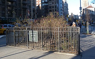
Sherman Square is a pocket park bounded by Broadway, Amsterdam Avenue, and West 70th Street on the Upper West Side of Manhattan, in New York City. It was named in 1891 for William Tecumseh Sherman who lived in the area and died that year.

The George Washington Bridge Plaza, also known as GWB Plaza or Bridge Plaza, is the convergence of roads and highways around the George Washington Bridge toll plaza in Fort Lee, New Jersey, United States. The plaza is located north of and parallel to Fort Lee's Main Street. The surrounding busy area is characterized by a mix of commercial and residential uses and an architectural variety that includes parking lots, strip malls, houses, gas stations, mid-rise office buildings and high-rise condominiums. Just to the east is Fort Lee Historic Park, Palisades Interstate Park and the bridge's western tower.

Broadway is an avenue in the New York City borough of Brooklyn that extends from the East River in the neighborhood of Williamsburg in a southeasterly direction to East New York for a length of 4.32 miles (6.95 km). It was named for the Broadway in Manhattan. The East New York terminus is a complicated intersection with East New York Avenue, Fulton Street, Jamaica Avenue, and Alabama Avenue. The BMT Jamaica Line of the New York City Subway runs on elevated tracks over Broadway from the Williamsburg Bridge to East New York on its way to Queens. Broadway forms the boundary between the neighborhoods of Bushwick, which lies above Broadway to the northeast, and Bedford–Stuyvesant, which is to the southwest.

East Broadway is a two-way east–west street in the Chinatown, Two Bridges, and Lower East Side neighborhoods of the New York City borough of Manhattan in the U.S. state of New York.
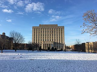
Concourse is a neighborhood in the southwestern section of the New York City borough of the Bronx which includes the Bronx County Courthouse, the Bronx Museum of the Arts, and Yankee Stadium. Its boundaries, starting from the north and moving clockwise, are East 169th Street to the north, Webster Avenue to the east, East 149th Street to the south, and Jerome Avenue and Harlem River to the west. The neighborhood is divided into three subsections: West Concourse, East Concourse, and Concourse Village with the Grand Concourse being its main thoroughfare.

Eldridge Street is a street in Manhattan's Lower East Side and Chinatown, running from Houston Street south to East Broadway. Originally called Third Street according to the numbering system for the Delancey Farm Grid, it was named in 1817 for Lt. Joseph C. Eldridge, whose unit was ambushed by Indian allies of the British in Upper Canada during the War of 1812.


