Broadway is a road in the U.S. state of New York. Broadway runs from State Street at Bowling Green for 13 mi (21 km) through the borough of Manhattan and 2 mi (3.2 km) through the Bronx, exiting north from New York City to run an additional 18 mi (29 km) through the Westchester County municipalities of Yonkers, Hastings-On-Hudson, Dobbs Ferry, Irvington, and Tarrytown, and terminating north of Sleepy Hollow.

New York City Hall is the seat of New York City government, located at the center of City Hall Park in the Civic Center area of Lower Manhattan, between Broadway, Park Row, and Chambers Street. Constructed from 1803 to 1812, the building is the oldest city hall in the United States that still houses its original governmental functions. The building houses the office of the Mayor of New York City and the chambers of the New York City Council. While the Mayor's Office is in the building, the staff of thirteen municipal agencies under mayoral control are located in the nearby Manhattan Municipal Building, one of the largest government buildings in the world, with many others housed in various buildings in the immediate vicinity.

Tribeca, originally written as TriBeCa, is a neighborhood in Lower Manhattan in New York City. Its name is a syllabic abbreviation of "Triangle Below Canal Street". The "triangle" is bounded by Canal Street, West Street, Broadway, and Chambers Street. By the 2010s, a common marketing tactic was to extend Tribeca's southern boundary to either Vesey or Murray Streets to increase the appeal of property listings.

The Financial District of Lower Manhattan, also known as FiDi, is a neighborhood located on the southern tip of Manhattan in New York City. It is bounded by the West Side Highway on the west, Chambers Street and City Hall Park on the north, Brooklyn Bridge on the northeast, the East River to the southeast, and South Ferry and the Battery on the south.
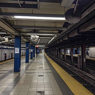
The Canal Street station is an express station on the IND Eighth Avenue Line of the New York City Subway. Located at the intersection of Canal Street, Vestry Street, and Sixth Avenue in Lower Manhattan, it is served by the A and E trains at all times, and the C train at all times except late nights.

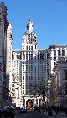
The David N. Dinkins Municipal Building is a 40-story, 580-foot (180 m) building at 1 Centre Street, east of Chambers Street, in the Civic Center neighborhood of Manhattan in New York City. The structure was built to accommodate increased governmental space demands after the 1898 consolidation of the city's five boroughs. Construction began in 1909 and continued through 1914 at a total cost of $12 million.

The Tweed Courthouse is a historic courthouse building at 52 Chambers Street in the Civic Center of Manhattan in New York City. It was built in the Italianate style with Romanesque Revival interiors. William M. "Boss" Tweed – the corrupt leader of Tammany Hall, a political machine that controlled the New York state and city governments when the courthouse was built – oversaw the building's erection. The Tweed Courthouse served as a judicial building for New York County, a county of New York state coextensive with the New York City borough of Manhattan. It is the second-oldest city government building in the borough, after City Hall.

Worth Street is a two-way street running roughly northwest-southeast in Manhattan, New York City. It runs from Hudson Street, TriBeCa, in the west to Chatham Square in Chinatown in the east. Past Chatham Square, the roadway continues as Oliver Street, a north-south street running one-way northbound. Between West Broadway and Church Street, Worth Street is also known as Justice John M. Harlan Way in honor of the Supreme Court justice and alumnus of the nearby New York Law School. Between Centre and Baxter Streets, Worth Street is also known as the "Avenue of the Strongest", "New York's Strongest" being a nickname for the city's Department of Sanitation.

West Broadway is a north-south street in the New York City borough of Manhattan, separated into two parts by Tribeca Park. The northern part begins at Tribeca Park, near the intersection of Avenue of the Americas, Walker Street and Beach Street in Tribeca. It runs northbound as a one-way street past Canal Street and becomes two-way at the intersection with Grand Street one block farther north. West Broadway then operates as a main north-south thoroughfare through SoHo until its northern end at Houston Street, on the border between SoHo and Greenwich Village. North of Houston Street, it is designated as LaGuardia Place, which continues until Washington Square South.

Greenwich Street is a north–south street in the New York City borough of Manhattan. It extends from the intersection of Ninth Avenue and Gansevoort Street in the Meatpacking District at its northernmost end to its southern end at Battery Park. Greenwich Street runs through the Meatpacking District, the West Village, Hudson Square, and Tribeca.

Tower 270 is a 28-story mixed use building in the Civic Center and Tribeca neighborhoods of Manhattan, New York City. Completed in 1930 to designs by E.H. Faile & Company, it has 350,785 square feet (32,589.0 m2) of floor space, on a plot with 50 feet (15 m) facing Broadway to the east and 242 feet (74 m) on Chambers Street to the north.

Dey Street is a short street in Lower Manhattan, in New York City. It passes the west side of the World Trade Center site and the World Trade Center Transportation Hub. It runs for one block between Church Street and Broadway. It originally ran to West Street, but the western reaches were demolished to make way for the World Trade Center in the late 1960s. It now extends to Greenwich Street. 15 Dey Street is the site of the first transcontinental telephone call.

Elizabeth H. Berger Plaza is a public park in the Financial District of Manhattan, New York City. formed by the triangular junction of Trinity Place, Greenwich Street and Edgar Street. It faces the Manhattan exit ramp from the Brooklyn–Battery Tunnel. Formerly known as the Edgar Street Greenstreet, this park honors civic advocate Elizabeth H. Berger (1960-2013). In her role as president of the Downtown Alliance, she advocated for the fusion of two traffic triangles at this location into an expanded park. The park is located on the site of a former neighborhood known as Little Syria, a bustling immigrant community displaced by the construction of the tunnel in 1953.