
The Wabash and Erie Canal was a shipping canal that linked the Great Lakes to the Ohio River via an artificial waterway. The canal provided traders with access from the Great Lakes all the way to the Gulf of Mexico. Over 460 miles long, it was the longest canal ever built in North America.

The Ohio and Erie Canal was a canal constructed during the 1820s and early 1830s in Ohio. It connected Akron with the Cuyahoga River near its outlet on Lake Erie in Cleveland, and a few years later, with the Ohio River near Portsmouth. It also had connections to other canal systems in Pennsylvania.
The Whitewater Valley Railroad is a heritage railroad in southeastern Indiana between Connersville and Metamora.
Tinker's Creek, in Cuyahoga, Summit and Portage counties, is the largest tributary of the Cuyahoga River, providing about a third of its flow into Lake Erie.

Navigable aqueducts are bridge structures that carry navigable waterway canals over other rivers, valleys, railways or roads. They are primarily distinguished by their size, carrying a larger cross-section of water than most water-supply aqueducts. Roman aqueducts were used to transport water and were created in Ancient Rome. The 662-metre (2,172 ft) long steel Briare aqueduct carrying the Canal latéral à la Loire over the River Loire was built in 1896. It was ranked as the longest navigable aqueduct in the world for more than a century, until the Magdeburg Water Bridge in Germany took the title in the early 21st century.
The Whitewater Canal, which was built between 1836 and 1847, spanned a distance of 76 miles (122 km) and stretched from Lawrenceburg, Indiana on the Ohio River to Hagerstown, Indiana near the West Fork of the White River.

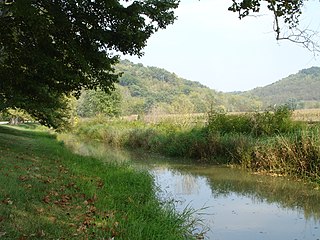
Metamora is an unincorporated town and census-designated place in Metamora Township, Franklin County, Indiana. The town was once a stop along the Whitewater Canal and is now primarily dependent on tourism. As of the 2010 census, it had a population of 188.

The Jackson Covered Bridge also known as the Rockport Covered Bridge is located in the 'forgotten town' of Rockport, northwest of Bloomingdale, Parke County, Indiana, USA.
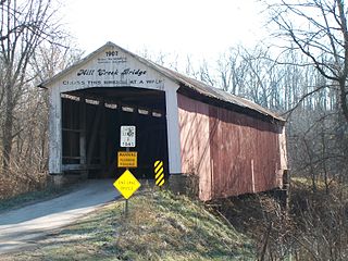
The Mill Creek Covered Bridge also known as "Thompson's Ford Covered Bridge," "Tow Path Covered Bridge," or "Earl Ray Covered Bridge" crosses Wabash Mill Creek (historic) southwest of Tangier, Indiana. It is a single span Burr Arch Truss covered bridge structure that was built by D. M. Brown in 1907.
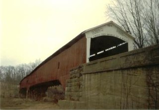
The West Union Covered Bridge formerly carried Tow Path Road over Sugar Creek north-northeast of Montezuma, Indiana. The two-span Burr Arch Truss covered bridge structure was built by Joseph J. Daniels in 1876. It is notable for being the longest standing covered bridge in Parke County, and one of the nation's best-preserved examples of the Burr truss.

Metamora Township is one of thirteen townships in Franklin County, Indiana. As of the 2010 census, its population was 974.

The Slateford Aqueduct is a navigable aqueduct that carries the Union Canal over the Water of Leith at Slateford, Edinburgh, Scotland. Completed in 1822, it has eight arches and spans a length of 500 feet (150 m).
The Avon Aqueduct is a navigable aqueduct that carries the Union Canal over the River Avon, near Linlithgow, Scotland.

Tinkers Creek Aqueduct is an aqueduct that was constructed to bridge the Ohio and Erie Canal over Tinkers Creek near its confluence with the Cuyahoga River in Valley View, Ohio. It is a relatively rare surviving example of an Ohio and Erie Canal aqueduct. It was originally constructed in 1825-1827 by, and re-built due to flood damage in 1845 and 1905. Tinkers Creek Aqueduct was included in a National Historic Landmark district established in 1966, and it was separately listed on the National Register of Historic Places in 1979. The original Tinkers Creek Aqueduct was a wood plank, steel truss, and Ashlar-sandstone structure constructed in 1827, south of the present aqueduct's location. Cuyahoga River and Tinkers Creek flooding caused continual damage to the original aqueduct, so successive structures were built in 1845 and 1905 in the present location. Today, Tinkers Creek Aqueduct is the only aqueduct which remains of the four original aqueducts in the Cuyahoga Valley. Of Furnace Run Aqueduct, Mill Creek Aqueduct, Peninsula Aqueduct, and Aqueduct; Mill Creek Aqueduct, of newer construction, is the only aqueduct which still carries Ohio and Erie Canal water. After 102 years of flooding, weathering, and deterioration, Tinkers Creek Aqueduct was removed in 2007. The National Park Service is currently working on Phase II of the project to reconstruct it from newer materials.

The Yosemite Valley Bridges are eight bridges in the Yosemite Valley of Yosemite National Park, most of them spanning the Merced River. Five of them were built in 1928, with the remainder built between 1921 and 1933. The bridges feature a concrete structure faced with local stone, in an elliptical or three-centered arch configuration. They are notable for their uniform character and for their conformance to tenets of the National Park Service rustic style. Design work for the seven newer bridges was by George D. Whittle of the San Francisco District Office of the U.S. Bureau of Public Roads for the National Park Service. Concrete bridges were chosen at the urging of Thomas Chalmers Vint of the Park Service, in lieu of alternative designs for steel truss bridges, or suspension bridges suggested by the park superintendent.
The Chesapeake and Ohio Canal (C&O) used 11 navigable aqueducts to carry the canal over rivers and streams that were too wide for a culvert to contain. Aqueducts, like locks and other masonry structures, were called "works of art" by the canal board of directors.

The Sulphite Railroad Bridge, also known locally as the Upside-Down Covered Bridge is a historic railroad bridge in Franklin, New Hampshire. The bridge was built circa 1896-7 to carry the tracks of the Boston and Maine Railroad across the Winnipesaukee River between Franklin and Tilton. The bridge is believed to be the only surviving "upside down" covered railroad bridge in the United States, in which the rail bed is laid on top of the bridge roof, whose purpose is to shelter the trusses below. The bridge was listed on the National Register of Historic Places in 1975. The bridge, unused since 1973, is not in good condition, having been subjected to graffiti, vandalism, and arson, as well as the elements.
Metamora Historic District is a national historic district located at Metamora, Franklin County, Indiana. The district encompasses 115 contributing buildings and 10 contributing structures in the central business district and surrounding residential sections of the village of Metamora. It developed between about 1838 and 1923, and includes notable examples of Italianate, Gothic Revival, and Greek Revival style architecture. Located in the district is the Duck Creek Aqueduct. Notable contributing buildings include the Odd Fellows Building (1853), Gordon Hall Building, Jonathan Banes House, Metamora Masonic Hall, Martindale House (1838), Metamora Christian Church (1871), Redmen Hall Building, and Farmers Bank of Metamora (1923).
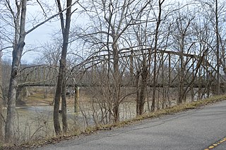
Cedar Grove Bridge, also known as Indiana State Bridge #6625B, was a historic Camelback Pratt Through Truss bridge spanning the Whitewater River in Cedar Grove and Highland Township, Franklin County, Indiana. The bridge had two spans and was built in 1914. Each span of the bridge was 180 feet long, and the overall length of the bridge was 386 feet and had a roadway 18 feet wide.

Brownsville Covered Bridge was a historic long truss covered bridge located at Brownsville, Union County, Indiana. It was built between 1837 and 1840, and was a single span covered timber bridge. It measured 182 feet (55 m) long and 21 feet 6 inches (6.55 m) wide. The bridge spanned the East Fork of the Whitewater River.


