Anaheim Hills is an affluent, planned community encompassing the eastern portions of the city of Anaheim, in Orange County, California.

The Witch Creek Fire, also known as the Witch Fire, was the second-largest wildfire of the 2007 California wildfire season, burning 197,990 acres (801 km2) of land in San Diego County. Fanned by powerful Santa Ana winds, the Witch Creek Fire rapidly spread westward and consumed large portions of San Diego County. During its duration, flames reached 80 to 100 feet high, and the Witch Fire exhibited the characteristics of a firestorm at its height.
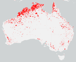
The summer of 2013–14 was at the time, the most destructive bushfire season in terms of property loss since the 2008–09 Australian bushfire season, with the loss of 371 houses and several hundred non-residential buildings as a result of wild fires between 1 June 2015 and 31 May 2016. The season also suffered 4 fatalities; 2 died in New South Wales, 1 in Western Australia and 1 in Victoria. One death was as a direct result of fire, 2 died due to unrelated health complications while fighting fires on their property, and a pilot contracted by the NSW Rural Fire Service died during an accident.
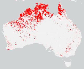
The bushfire season in the summer of 2014–15, was expected to have the potential for many fires in eastern Australia after lower than expected rainfall was received in many areas. Authorities released warnings in the early spring that the season could be particularly bad.

2014 saw several notable wildfires igniting in California, especially during the month of May, when multiple fires were ablaze concurrently in Southern California, and during September, when several massive wildfires were burning in Northern California. In the context of the 2012–13 North American drought, as well as powerful Santa Ana winds, weather conditions were ideal for wildfires. A total of 7,865 wildfires ignited throughout the year, which burned at least 625,540 acres (2,531.5 km2) of land. The wildfires caused a total of 146 injuries and 2 fatalities, in addition to causing at least $204.05 million in damage.
The Bernardo Fire was a wildfire that occurred during the May 2014 San Diego County wildfire outbreak. The Bernardo fire was the second of the May 2014 wildfires in San Diego County, and the first of the swarm of wildfires that ignited in mid-May, following dry weather and Santa Ana conditions. The fire ignited in 4S Ranch in San Diego County, on May 13, near Del Norte High School, and eventually spread southward and westward, burning 1,548 acres (6 km2) of land. The Bernardo Fire was extinguished on May 17, without causing any significant property losses.
The Poinsettia Fire was the second most destructive of the May 2014 San Diego County wildfires. It caused property damage estimated at $22.5 million, as well as the only reported fatality in the San Diego County series of wildfires. As of July 10, 2014, the cause of the fire is listed as "undetermined", which allows for further investigation if more information comes to light.
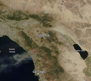
The May 2014 San Diego County wildfires were a swarm of 20 wildfires that erupted during May 2014, in San Diego County, California, during severe Santa Ana Wind conditions, historic drought conditions, and a heat wave. The main event during mid-May was preceded by a precursor fire that ignited on May 5. The Bernardo Fire has been declared accidental, and officials believe the Cocos Fire was intentionally set. The causes of the other fires are still under investigation by multiple agencies, and a joint task force was formed to coordinate the investigations and facilitate communications. Six injuries and one fire-related fatality were reported.
Cocos Fire, originally known as the Twin Oaks Fire, was a wildfire that ignited on May 14, 2014 in San Marcos, California, in the hills south of California State University, San Marcos. The Cocos Fire quickly spread into western Escondido. The fire destroyed more than 40 buildings, including a dozen single-family homes. The Harmony Grove Spiritualist Association, a 13-acre spiritualist retreat founded in 1896, was particularly hard hit; most of the buildings and residences on the property were destroyed, and the association's president said, "We're pretty much wiped out." Property damage from the fire is estimated at more than $5.7 million. Three minor injuries have been reported. The Cocos Fire was the last of the May 2014 wildfires in San Diego County to be extinguished, with full containment on May 22, 2014.

The Boles Fire was a wildfire that burned in Siskiyou County during mid-September 2014. On September 15, at 1:38 p.m. PDT, the Boles Fire ignited near Weed, California. Later on the same day, at 10:30 p.m. PDT, the Boles Fire was reported at 350 acres and 15% containment. Over 100 structures were reported damaged or destroyed on that day. Later that day, the wildfire was reported at nearly 100% containment; however, this report turned out to be erroneous. On September 16, the Boles Fire had burned 375 acres (152 ha) and was only 20% contained. It also destroyed 150 residences and forced the evacuation of 1,500 people in Weed and Siskiyou County.

The October 2007 California wildfires, also known as the Fall 2007 California firestorm, were a series of about thirty wildfires that began igniting across Southern California on October 20. At least 1,500 homes were destroyed and approximately 972,147 acres of land was burned from Santa Barbara County to the U.S.–Mexico border, surpassing the October 2003 California wildfires in scope, which were estimated to have burned 800,000 acres (3,200 km2). The wildfires killed a total of 14 people, with nine of them dying directly from the fires; 160 others were injured, including at least 124 firefighters. At their height, the raging fires were visible from space. These fires included the vast majority of the largest and deadliest wildfires of the 2007 California wildfire season. The only wildfire in 2007 that surpassed any of the individual October 2007 fires in size was the Zaca Fire.

The Barry Point Fire was a wildfire that burned over 92,977 acres (376.26 km2) of Oregon and California forest land during the summer of 2012. The fire began on 5 August 2012, the result of a lightning strike. The fire consumed public forest and rangeland as well as private forest and grazing land located in Lake County, Oregon and Modoc County, California. The public lands affected by the fire are administered by the United States Forest Service and the Oregon Department of Forestry. The largest part of the private land was owned by the Collins Timber Company. At the peak of the firefighting effort, there were 1,423 personnel working on the fire. It took 22 days to fully contain the fire and then an additional three weeks to mop it up.

The Whittier Fire was a wildfire in the Santa Ynez Mountains, south of Lake Cachuma, along Highway 154 in Santa Barbara County, California in the United States. The fire was reported on July 8, 2017, at 1:43 pm. Upon containment on July 28, the fire had burned a total of 18,430 acres (75 km2) and destroyed 16 homes.

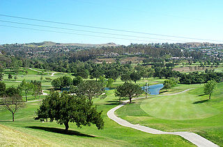
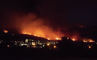
The Canyon Fire 2, also known as the Canyon 2 Fire, was a wildfire that burned in the Anaheim Hills area of the city of Anaheim in Orange County, California. The fast-moving brush fire broke out on October 9, 2017, around 9:45 A.M. PDT near the 91 Freeway and Gypsum Canyon Road. It leaped over the Route 241 toll road, raced up a ridge, and set fire to several homes. In total, about 16,570 were ordered to evacuate their homes in Anaheim, Orange, and Tustin but returned when the evacuation order was lifted on October 12.
The Labor Day brush fire was a small brush fire that burned parts of Rancho Peñasquitos and Black Mountain Open Space Park in September 2005, during the 2005 California wildfire season. Despite its small size, the brush fire was the worst wildfire to affect San Diego City in two years, since the Cedar Fire of 2003. The wildfire resulted in 6 injuries, but did not result in structural damages. The brush fire was determined to have been started by a teenage boy, who was subsequently arrested.

The Lilac Fire was a fire that burned in northern San Diego County, California, United States, and the second-costliest one of multiple wildfires that erupted in Southern California in December 2017. The fire was first reported on December 7, 2017, burned 4,100 acres (1,659 ha), and destroyed 157 structures, before it was fully contained on December 16. The fire cost at least $8.9 million, including $5 million in firefighting expenses and property damage, and an additional $3.9 million in cleanup and erosion control costs. The fire threatened the communities of Bonsall, Oceanside, Vista, Fallbrook, and Camp Pendleton. During the fire, an estimated 10,000 residents were forced to evacuate, while a total of over 100,000 residents were forced to or advised to evacuate. On December 7, the Lilac Fire also cut the power to 20,000 people.
The Tenaja Fire was a wildfire in the rural community of La Cresta southwest of Murrieta in Riverside County, California, United States, located 80 miles from Los Angeles. The fire broke out on Wednesday, September 4, 2019 and ballooned to 1,926 acres (8 km2) over the course of two days. The blaze, dubbed the Tenaja fire after igniting along Tenaja Road and Clinton Keith Road in La Cresta, forced the evacuation of over 1,200 people and lead to the closure of multiple school districts in the Murrieta, Perris and Lake Elsinore area due to the poor air quality. The exact cause of the fire remains under investigation although several sources cited the possibility of lightning being the direct cause. Two structures were damaged as a result of the fire and one firefighter suffered minor injuries. The fire was contained on September 14 and had burned 1,926 acres (779 ha).

The Apple Fire was a wildfire that burned during the 2020 California wildfire season in Cherry Valley south of Oak Glen and north of Beaumont and Banning in Riverside County, California in the United States. The fire ignited on Friday, July 31, 2020 as three separate smaller blazes within the rural canyons along Oak Glen Road before merging and rapidly expanded to 1,900 acres (769 ha) and destroyed at least one home and two outbuildings in the Cherry Valley area. It now covers at least 33,424 acres (13,526 ha) and created "a plume of smoke so massive that it generated its own winds." The fire was sparked by a diesel-burning vehicle that emitted burning carbon.

The 2020 Maricopa County wildfires were a series of major and non-major wildfires that took place in Maricopa County, Arizona, from the month of May to the month of October. In the year 2020, Arizona saw one of its worst fire seasons in the states history. Due to the lack of precipitation needed in Arizona, the state fell into an ongoing drought from late 2020 and 2021. High winds were also present during the summer when fire season is mostly active in the state. These factors led to the wildfires in Maricopa County to be destructive and costly.

The Border 32 Fire was a destructive wildfire that burned amid the 2022 California wildfire season, in the Barrett Junction area along Highway 94 due north of the United States-Mexican border in San Diego County, California during a statewide heatwave. The fire started on August 31, 2022, and proceeded to destroy ten structures and eventually grow to 4,456 acres (1,803 ha) within the rugged chaparral-dense hillsides throughout the area.
