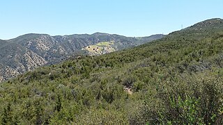
The Santa Ana Mountains are a short peninsular mountain range along the coast of Southern California in the United States. They extend for approximately 61 miles (98 km) southeast of the Los Angeles Basin largely along the border between Orange and Riverside counties.

Trabuco Canyon is a small unincorporated community located in the foothills of the Santa Ana Mountains in eastern Orange County, California, and lies partly within the Cleveland National Forest.
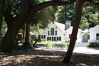
Silverado is an unincorporated community in Silverado Canyon, which is located in the Santa Ana Mountains in eastern Orange County, California. Portions of the town sit on a former Mexican land grant Rancho Lomas de Santiago. Silverado is located at the boundaries of Cleveland National Forest. The site is a California Historical Landmark, and is located near the village site of Puhú.
The Santiago Canyon Fire of 1889 was a massive wildfire in California, which burned large parts of Orange County, Riverside County, and San Diego County during the last week of September 1889. The fire reportedly started in Fremont Canyon, a canyon close to what today is Irvine Lake. Until 2018, it was possibly the single largest wildfire in the recorded history of California, with at least 300,000 acres (1,200 km2) of land burned. In mid-August 2018, the Ranch Fire in the Mendocino Complex Fire surpassed the Santiago Canyon Fire's assumed acreage.
Modjeska Canyon is an unincorporated community and census designated place (CDP) on the western slope of the Santa Ana Mountains in eastern Orange County, California. It is a suburban community of several hundred residents, with a small park and a volunteer fire station. The ZIP Code is 92676, and the community is inside area code 714.

The Orange County Fire Authority (OCFA) is the agency that provides fire protection and emergency medical services for unincorporated areas of Orange County, California as well as 25 cities within the county that contract OCFA's services. There are 7 divisions and 11 battalions.

Modjeska Peak is the northern mountain of the Saddleback landform in Orange County California. It is the second-highest peak of the Santa Ana Mountains, after Santiago Peak, whose summit is less than 0.6 mi (0.97 km) to the northwest. Modjeska lies within Cleveland National Forest and, despite being shorter than Santiago, has a smaller peak without manmade structures to obstruct views of the Pacific Ocean and San Gabriel Mountains.
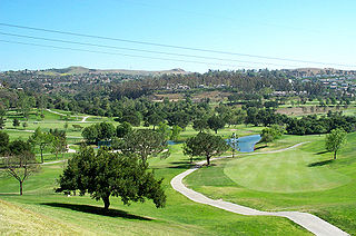
Anaheim Hills is an affluent, planned community encompassing the eastern portions of the city of Anaheim, in Orange County, California.
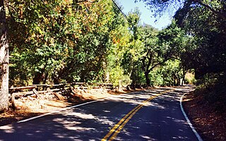
Santiago Canyon is a canyon and unincorporated community in South Orange County, California. According to the 2000 census, Santiago Canyon has several hundred residents living within its borders. Trabuco Canyon, Silverado Canyon, Modjeska Canyon and Williams Canyon are tributaries of Santiago Canyon. Santiago Creek flows northwest from the canyon, then west into the Santa Ana River. Neighborhoods in Santiago Canyon include Santiago Canyon Estates and Falcon View Estates. The landmark Cook's Corner motorcycle restaurant is also located within Santiago Canyon.

The 2007 California wildfire season saw at least 9,093 separate wildfires that charred 1,520,362 acres (6,152.69 km2) of land. Thirty of those wildfires were part of the Fall 2007 California firestorm, which burned approximately 972,147 acres of land from Santa Barbara County to the U.S.–Mexico border. At the peak of the wildfire activity in October 2007, the raging wildfires were visible from space.

Cook's Corner is an Orange County, California bar built in 1884 that is popular with motorcyclists. It is located between the city of Lake Forest and the unincorporated community of Silverado. Cook's Corner is situated in Trabuco Canyon, California at the intersection of Santiago Canyon Road and Live Oak Canyon Road.

The Orange County Board of Supervisors is the five-member governing body of Orange County, California along with being the executive of the county.

Santiago Creek is a major watercourse in Orange County in the U.S. state of California. About 34 miles (55 km) long, it drains most of the northern Santa Ana Mountains and is a tributary to the Santa Ana River. It is one of the longest watercourses entirely within the county. The creek shares its name with Santiago Peak, at 5,687 ft (1,733 m) the highest point in Orange County, on whose slopes its headwaters rise.

The October 2007 California wildfires, also known as the Fall 2007 California firestorm, were a series of about thirty wildfires that began igniting across Southern California on October 20. At least 1,500 homes were destroyed and approximately 972,147 acres of land was burned from Santa Barbara County to the U.S.–Mexico border, surpassing the October 2003 California wildfires in scope, which were estimated to have burned 800,000 acres (3,200 km2). The wildfires killed a total of 14 people, with nine of them dying directly from the fires; 160 others were injured, including at least 124 firefighters. At their height, the raging fires were visible from space. These fires included the vast majority of the largest and deadliest wildfires of the 2007 California wildfire season. The only wildfire in 2007 that surpassed any of the individual October 2007 fires in size was the Zaca Fire.
The Holy Fire was a wildfire that burned in the Cleveland National Forest in Orange and Riverside Counties, California. The wildfire started on August 6, 2018 at around 1:15 PM PDT, in the vicinity of Trabuco Canyon. A suspected arsonist was booked into the Orange County jail in Santa Ana, California but found not guilty in 2023. The blaze burned 23,136 acres (94 km2) and destroyed 18 buildings, before it was fully contained on September 13, 2018. While the fire was actively spreading in early and mid-August, residents of the nearby cities of Corona, Temescal Valley, and Lake Elsinore were placed under evacuation orders.
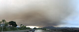
The Silverado Fire was a wildfire that burned in October and November 2020 in southern Orange County, California northeast of Irvine. The fire started on October 26 around 6:47 AM near Orange County Route S-18 and Silverado Canyon Road, fueled by strong Santa Ana winds gusting up to 80 miles per hour (130 km/h) and low humidity. Orange County Fire Authority Chief Brian Fennessy stated, "The winds were extraordinary even by Santa Ana standards. Fire spread is exceeding more than anything I've seen in my 44 years." The fire initially moved south from Loma Ridge toward the Orchard Hills, Northwood and Portola Springs communities of Irvine before moving southeast through Limestone Canyon and toward the communities of Foothill Ranch and Lake Forest. The fire burned in a path similar to that taken by the 2007 Santiago Fire, mostly through terrain that had not seen significant burning in the 13 years since that fire. 100% containment was announced on November 7, 2020.

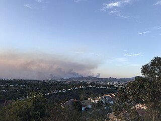
The Bond Fire was a wildfire that burned 6,686 acres (2,706 ha) in the Santiago Canyon area of Orange County, California in December 2020. The fire caused evacuations of 25,000 residents and injured 2 firefighters. The fire was very close to the burn scar of the Silverado Fire, which took place in October 2020.
The Municipal Water District of Orange County, commonly known by the acronym MWDOC, is a wholesale water provider, water resource development and planning agency., water-centric information, education, emergency planning, and conservation resource hub for nearly 3.2 millionOrange County, California residents, and businesses. Local water supply sources meet only about half of the region's total water needs. To fulfill the remaining demand, MWDOC buys imported water from the California State Water Project in northern California and the Colorado River through the Metropolitan Water District of Southern California (Metropolitan). MWDOC delivers water to its 27 member agencies - made up of both water districts and city water departments - who then, in turn, provide retail water service to the public.

Whiting Ranch Wilderness Park is a public regional park in southern Orange County, California. Whiting Ranch features riparian, oak woodland, grassland, chaparral, and coastal sage scrub environments throughout various canyons and hillscapes. The 2,500-acre park mostly encompasses unincorporated land just outside of Lake Forest. The park is home to over 17 miles of trail spread out over 23 different paths, making the location a popular destination for mountain bikers, hikers, and horseback riders.

