The Angora Fire was a 2007 wind-driven wildfire in El Dorado County, California. It started near North Upper Truckee Road subdivision near Angora Lakes, Fallen Leaf Lake, Echo Lake and South Lake Tahoe, California around 2:15 PM on Sunday, June 24, 2007, as a result of an illegal campfire. As of July 2, 2007, the fire was 100% contained, and 100% control was achieved on July 10. The fire burned 3,100 acres (12.5 km2), destroyed 242 residences and 67 commercial structures, and damaged 35 other homes. At the peak of the fire, there were as many as 2,180 firefighters involved in battling the blaze. The fire cost $13.5 million to fight and caused at least $150 million in property damage.

The Clover Fire was a fatal wildfire in Shasta County, California. It burned from September 9 to September 15, 2013 in an area near the communities of Happy Valley and Igo, California, about 10 miles southwest of Redding. It burned more than 8,000 acres (3,200 ha) and caused one death and six injuries. Damages were estimated at $65 million. One man has been charged with arson in the case.

The 2014 King Fire was a large wildfire in El Dorado County, California, which burned 97,717 acres primarily in the Eldorado National Forest. The wildfire started on September 13, 2014, near Pollock Pines, California, to the east of Sacramento. The ensuing fire suppression effort, which cost more than $100 million and engaged more than 8,000 personnel at its peak, allowed for the full containment of the King Fire by October 9, 2014. Despite the size and ferocity of the fire, it caused no deaths. Eighty structures were destroyed, the majority of them outbuildings. The King Fire was determined to have been caused by an act of arson and a suspect was swiftly apprehended and convicted in 2016.
The Lake Fire was a wildfire that burned in the San Bernardino National Forest. The fire started on June 17, 2015, and burned over 31,359 acres before it was fully contained on July 21, 2015.
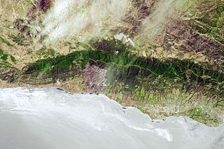
The Sherpa Fire was a wildfire that burned in the Santa Ynez Mountains along the Gaviota Coast in the southwestern part of Santa Barbara County, California in June 2016. In a matter of hours the fire spread to over 1,400 acres (570 ha) as the fire was propelled by downslope sundowner winds. This offshore northerly wind contrasts with the more typical onshore flow and sent the fire down the canyons towards the ocean with gusts of over 35 miles per hour (56 km/h). The wildfire resulted in evacuations at two state beach campgrounds and some residences together with intermittent interruption of traffic on a state transportation route.

The Blue Cut Fire was a wildfire in the Cajon Pass, northeastern San Gabriel Mountains, and Mojave Desert in San Bernardino County, California. The fire, which began on the Blue Cut hiking trail in the San Bernardino National Forest, was first reported on August 16, 2016 at 10:36 a.m., just west of Interstate 15. A red flag warning was in effect in the area of the fire, with temperatures near 100 °F (38 °C) and winds gusting up to 30 miles per hour (48 km/h).
The Holcomb Fire was a wildfire that burned due north of Big Bear Lake near Highway 18 in the San Bernardino National Forest in San Bernardino County, California. Within several days, the fire would consume some 1,500 plus acres as it threatened the areas of Baldwin Lake and Highway 18. However, while the fire rapidly grew in size, the head of the fire was seen to be moving away from structures, thus leaving evacuated areas under voluntary evacuation.

The Thomas Fire was a massive wildfire that affected Ventura and Santa Barbara Counties, and one of multiple wildfires that ignited in southern California in December 2017. It burned approximately 281,893 acres before being fully contained on January 12, 2018, making it the largest wildfire in modern California history at the time. It was surpassed by the Ranch Fire, part of the Mendocino Complex, in August 2018. The fire is currently the seventh-largest wildfire in modern California history, as of 2021. The fire was officially declared out on June 1, 2018, after more than two months in which no hotspots were detected. The Thomas Fire destroyed at least 1,063 structures, while damaging 280 others; and the fire caused over $2.2 billion in damages, including $230 million in suppression costs, becoming the seventh-most destructive wildfire in state history at the time. As of August 2020, the Thomas Fire is California's tenth-most destructive wildfire. Ventura's agriculture industry suffered at least $171 million in losses due to the Thomas Fire.

The Creek Fire was a large wildfire that burned in Kagel Canyon and the Angeles National Forest north of Sylmar, a neighborhood in Los Angeles, California, United States, and one of multiple wildfires that broke out across Southern California in December 2017. The Creek Fire burned 15,619 acres (63 km2) and destroyed 123 structures, including 60 homes, before being contained on January 9, 2018, following heavy rainfall from a winter storm. The fire threatened the communities of Santa Clarita, Glendale, Olive View, Lake View Terrace, Sunland-Tujunga, Shadow Hills, Sylmar, Pacoima, Lopez Canyon, and Kagel Canyon, as well as the Olive View–UCLA Medical Center. During the wildfire, 115,000 residents were forced to evacuate their homes.
A series of 29 wildfires ignited across Southern California in December 2017. Six of the fires became significant wildfires, and led to widespread evacuations and property losses. The wildfires burned over 307,900 acres (1,246 km2), and caused traffic disruptions, school closures, hazardous air conditions, and power outages; over 230,000 people were forced to evacuate. The largest of the wildfires was the Thomas Fire, which grew to 281,893 acres (1,140.78 km2), and became the largest wildfire in modern California history, until it was surpassed by the Ranch Fire in the Mendocino Complex, in the following year.
The Holy Fire was a wildfire that burned in the Cleveland National Forest in Orange and Riverside Counties, California. The wildfire started on August 6, 2018 at around 1:15 PM PDT, in the vicinity of Trabuco Canyon. A suspected arsonist was booked into the Orange County jail in Santa Ana, California but found not guilty in 2023. The blaze burned 23,136 acres (94 km2) and destroyed 18 buildings, before it was fully contained on September 13, 2018. While the fire was actively spreading in early and mid-August, residents of the nearby cities of Corona, Temescal Valley, and Lake Elsinore were placed under evacuation orders.
The Mangum Fire was a wildfire in Kaibab National Forest in Arizona in the United States. The fire, which started on June 8, 2020 approximately 16 miles north of the North Rim of Grand Canyon National Park, burned a total of 71,450 acres (28,915 ha). The fire threatened the community of Jacob Lake, Arizona, resulting in its evacuation. Select highways were closed, including Highway 67, which resulted in closure of the North Rim of the Grand Canyon. Additionally, areas of the Paria Canyon-Vermilion Cliffs Wilderness were inaccessible due to closures. Four buildings were destroyed, including two historic cabins. The exact cause of the fire remains under investigation, however, fire officials have confirmed it was human caused.

The Bobcat Fire was a large wildfire in Los Angeles County and one of the major incidents of the 2020 California wildfire season. The fire ignited on September 6, 2020, and burned 115,997 acres (46,942 ha) before it was fully contained by November 27. The Bobcat Fire primarily burned in the central San Gabriel Mountains, in and around the Angeles National Forest, and is one of the largest fires on record in Los Angeles County to date.
The Silverado Fire was a wildfire that burned in October and November 2020 in southern Orange County, California northeast of Irvine. The fire started on October 26 around 6:47 AM near Orange County Route S-18 and Silverado Canyon Road, fueled by strong Santa Ana winds gusting up to 80 miles per hour (130 km/h) and low humidity. Orange County Fire Authority Chief Brian Fennessy stated, "The winds were extraordinary even by Santa Ana standards. Fire spread is exceeding more than anything I've seen in my 44 years." The fire initially moved south from Loma Ridge toward the Orchard Hills, Northwood and Portola Springs communities of Irvine before moving southeast through Limestone Canyon and toward the communities of Foothill Ranch and Lake Forest. The fire burned in a path similar to that taken by the 2007 Santiago Fire, mostly through terrain that had not seen significant burning in the 13 years since that fire. 100% containment was announced on November 7, 2020.

The Bond Fire was a wildfire that burned 6,686 acres (2,706 ha) in the Santiago Canyon area of Orange County, California in December 2020. The fire caused evacuations of 25,000 residents and injured 2 firefighters. The fire was very close to the burn scar of the Silverado Fire, which took place in October 2020.

The French Fire was a wildfire that burned 26,535 acres (10,738 ha) near Shirley Meadows west of Lake Isabella in Kern County, California in the United States during the 2021 California wildfire season. The fire was initially reported on Wednesday, August 18, 2021, and ended around October 24, 2021. The fire threatened the communities of Shirley Meadows, Alta Sierra and Wofford Heights. The fire is currently 99% contained and has also reportedly destroyed some 17 structures, including 9 residences. The cause of the fire remains under investigation.
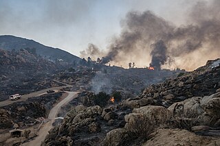
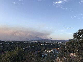
The Fairview Fire is a deadly and destructive wildfire that burned during the 2022 California wildfire season southwest of Valle Vista and east of Hemet in Riverside County, California in the United States. The fire ignited on September 5, 2022, during a severe heatwave that had plagued much of the southwest throughout early September and, due to the extreme weather conditions, grew to a deadly and destructive conflagration in the chaparral-filled foothills within just several hours of igniting.

The Silver Fire was a 1987 wildfire in the Siskiyou National Forest in Oregon. It burned 96,240 acres (389 km2), of which 42,350 acres (171 km2) was located in the Kalmiopsis Wilderness. Parts of its burned area were re-burned in the Biscuit Fire and the Chetco Bar Fire. It was started by a lightning strike near Silver Creek on August 30, and was contained on November 2 after a dry summer in the area, with relative humidity as low as 4% at times in certain places, was ended by heavy rain. Firefighters from across the country, as far away as Virginia, went to Oregon to fight the fire. Nearly 4,000 people were involved in the effort.
The 1999 Jones Fire was a destructive wildfire in the U.S. state of California's Shasta County. The fire ignited on October 16, and was contained on October 19, 1999. It burned 26,200 acres (10,600 ha), destroyed 954 structures, and resulted in one fatality, becoming the then-second most destructive wildfire ever recorded in California, behind only the Oakland firestorm of 1991. As of 2023 it remains one of the 20 most destructive wildfires in the history of the state. The cause of the fire was never determined.

The 2002 Copper Fire was a wildfire in the U.S. state of California's Los Angeles County, and one of the more significant incidents of the state's 2002 wildfire season. After igniting on June 5 near the city of Santa Clarita, the fire burned for a week and consumed 23,407 acres, damaging wildlife habitat and historic structures in the Angeles National Forest before it was fully contained on June 12. The fire destroyed more than two dozen buildings and resulted in at least eight firefighter injuries. The government eventually sued two contractors whose equipment and negligence it argued had sparked the fire during construction work, resulting in a jury award in its favor of over $36 million.

