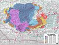
The Zaca Fire was a wildfire in the San Rafael Mountains, northeast of the Santa Ynez Valley in Santa Barbara County, California. It was the single largest wildfire of the 2007 California wildfire season. The fire started on July 4, 2007, and by August 31, it had burned over 240,207 acres (972.083 km2), making it California's second largest fire in recorded history at that time after the Cedar Fire of 2003. As of 2023, it is California's 12th-largest recorded fire in modern history. The fire was contained on September 4, 2007, with the fire being brought under control on October 29, 2007.

The 2009 California wildfires were a series of 9,159 wildfires that were active in the US state of California, during the year 2009. The fires burned more than 422,147 acres of land from early February through late November, due to Red Flag conditions, destroying hundreds of structures, injuring 134 people, and killing four. The wildfires also caused at least US$134.48 million in damage. Although the fires burned many different regions of California in August, the month was especially notable for several very large fires which burned in Southern California, despite being outside of the normal fire season for that region.
The Rim Fire was a massive wildfire that started in a remote canyon in the Stanislaus National Forest in California's Tuolumne County. The fire ignited on August 17, 2013, amid the 2013 California wildfire season, and burned 257,314 acres in largely remote areas of the Sierra Nevada, including a large portion of Yosemite National Park. The Rim Fire was fully contained on Thursday, October 24, 2013, after a nine-week suppression effort by firefighters. Due to a lack of winter rains, some logs smoldered in the interior portion of the fire footprint throughout the winter, and more than a year passed before the fire was declared totally extinguished in November 2014.

The 2015 California wildfire season was a series of wildfires that burned across the state of California. By the end of 2015 a total of 8,745 fires were recorded, burning 893,362 acres (3,615 km2) across the state. Approximately 3,159 structures were damaged or destroyed by wildfires, and at least 7 fatalities were recorded.

The October 2007 California wildfires, also known as the Fall 2007 California firestorm, were a series of about thirty wildfires that began igniting across Southern California on October 20. At least 1,500 homes were destroyed and approximately 972,147 acres of land was burned from Santa Barbara County to the U.S.–Mexico border, surpassing the October 2003 California wildfires in scope, which were estimated to have burned 800,000 acres (3,200 km2). The wildfires killed a total of 14 people, with nine of them dying directly from the fires; 160 others were injured, including at least 124 firefighters. At their height, the raging fires were visible from space. These fires included the vast majority of the largest and deadliest wildfires of the 2007 California wildfire season. The only wildfire in 2007 that surpassed any of the individual October 2007 fires in size was the Zaca Fire.

The Rough Fire was a major wildfire in Fresno County, California, and the largest of the 2015 California wildfire season. The fire was ignited by a lightning strike on July 31 and burned 151,623 acres (61,360 ha), largely in the Sierra National Forest and the Sequoia National Forest, before it was declared contained on November 6, 2015. At the time it occurred, the fire was the thirteenth largest in recorded California history.

The Soberanes Fire was a large wildfire that burned from July to October 2016 in the Santa Lucia Mountains of Monterey County, California. It destroyed 57 homes and killed a bulldozer operator, and cost about $260 million to suppress, making it at the time the most expensive wildfire to fight in United States history. At the fire's peak, over 5,000 personnel were assigned to the blaze. The fire was the result of an illegal campfire in Garrapata State Park. By the time it was finally extinguished, the fire had burned 132,127 acres (53,470 ha) along the Big Sur coast in the Los Padres National Forest, Ventana Wilderness, and adjacent private and public land in Monterey County, ranking it 18th on the list of the largest California wildfires in terms of acreage burned.

The Thomas Fire was a massive wildfire that affected Ventura and Santa Barbara Counties, and one of multiple wildfires that ignited in southern California in December 2017. It burned approximately 281,893 acres before being fully contained on January 12, 2018, making it the largest wildfire in modern California history at the time. It was surpassed by the Ranch Fire, part of the Mendocino Complex, in August 2018. The fire is currently the seventh-largest wildfire in modern California history, as of 2021. The fire was officially declared out on June 1, 2018, after more than two months in which no hotspots were detected. The Thomas Fire destroyed at least 1,063 structures, while damaging 280 others; and the fire caused over $2.2 billion in damages, including $230 million in suppression costs, becoming the seventh-most destructive wildfire in state history at the time. As of August 2020, the Thomas Fire is California's tenth-most destructive wildfire. Ventura's agriculture industry suffered at least $171 million in losses due to the Thomas Fire.
A series of 29 wildfires ignited across Southern California in December 2017. Six of the fires became significant wildfires, and led to widespread evacuations and property losses. The wildfires burned over 307,900 acres (1,246 km2), and caused traffic disruptions, school closures, hazardous air conditions, and power outages; over 230,000 people were forced to evacuate. The largest of the wildfires was the Thomas Fire, which grew to 281,893 acres (1,140.78 km2), and became the largest wildfire in modern California history, until it was surpassed by the Ranch Fire in the Mendocino Complex, in the following year.

The Donnell Fire was a wildfire that started on August 1, 2018 due to an unattended illegal campfire, near Donnell Reservoir, burning around California State Route 108 in Tuolumne County, California and in the Stanislaus National Forest. It spread rapidly, and the Forest Service closed a California state highway, many forest service roads, campgrounds, wilderness areas, access to privately-owned inholdings, and the Pacific Crest Trail. The fire burned 36,450 acres (147.5 km2), and destroyed 54 major structures and 81 minor structures, before the fire burned out on October 1. There were nine injuries caused by the fire, but no deaths.

The 2019 California wildfire season was a series of wildfires that burned across the U.S. state of California as part of the 2019 wildfire season. By the end of the year, according to Cal Fire and the US Forest Service, 7,860 fires were recorded, totaling an estimated of 259,823 acres of burned land. These fires caused 22 injuries, 3 fatalities, and damaged or destroyed 732 structures. The 2019 California fire season was less active than that of the two previous years, which set records for acreage, destructiveness, and deaths.
The Tucker Fire was a wildfire that burned near Clear Lake National Wildlife Refuge in Modoc County, California in the United States. The fire ignited on Sunday, July 28, 2019 along Highway 139 and went on to burn an estimated 14,217 acres of land. As of August 15, the fire was 95% contained. Officials say the wildfire was caused by traffic on Highway 139.

The Lake Fire was a wildfire that burned during the 2020 California wildfire season in the Angeles National Forest in Los Angeles County in the state of California in the United States. The fire, which was first reported on August 12, 2020, burned 31,089 acres (12,581 ha) near Lake Hughes. It was fully contained on September 28. The cause of the fire remains unknown. The fire has damaged 3 structures, destroyed 12 structures and 21 outbuildings, and injured 4 firefighters.

The 2020 Creek Fire was a very large wildfire in central California's Sierra National Forest, in Fresno and Madera counties. One of the most significant fires of California's record-setting 2020 wildfire season, it began on September 4, 2020, and burned 379,895 acres (153,738 ha) over several months until it was declared 100% contained on December 24, 2020. The Creek Fire is the fifth-largest wildfire in recorded California history and the second-largest single fire—i.e. not part of a larger wildfire complex—following the 2021 Dixie Fire.

The Bobcat Fire was a large wildfire in Los Angeles County and one of the major incidents of the 2020 California wildfire season. The fire ignited on September 6, 2020, and burned 115,997 acres (46,942 ha) before it was fully contained by November 27. The Bobcat Fire primarily burned in the central San Gabriel Mountains, in and around the Angeles National Forest, and is one of the largest fires on record in Los Angeles County to date.

The Lava Fire was a wildfire that burned 26,409 acres (10,687 ha) along the slopes of Mount Shasta near Weed, California during the 2021 California wildfire season. The fire started on June 25, 2021 and was fully contained on September 3, 2021. The fire destroyed 23 buildings, including 14 houses, as well as damaged an additional building.
The Tamarack Fire was a wildfire that burned 68,637 acres (27,776 ha), primarily in the Mokelumne Wilderness in Alpine County, California, Douglas County, Nevada and Lyon County, Nevada, as part of the 2021 California wildfire season.
The Tennant Fire was a wildfire that burned in the Klamath National Forest in Siskiyou County, California, in the United States as part of the 2021 California wildfire season. The fire was first reported just east of Highway 97, three miles northwest of Bray, California on June 28, 2021. The fire was contained on July 12, 2021. The fire burned 10,580 acres (4,282 ha), destroyed five structures, and caused evacuations in Macdoel, California. The cause remains under investigation. The Tennant Fire was one of three fires burning at the same time in the Lake Shasta region, the others being the Lava Fire and the Salt Fire.

The 2022 California wildfire season was a series of wildfires throughout the U.S. state of California. By the end of the year, a total of 7,667 fires had been recorded, totaling approximately 363,939 acres across the state. Wildfires killed nine people in California in 2022, destroyed 772 structures, and damaged another 104. The 2022 season followed the 2020 and 2021 California wildfire seasons, which had the highest and second-highest (respectively) numbers of acres burned in the historical record, with a sharp drop in acreage burned.