
The 2009 California wildfires were a series of 9,159 wildfires that were active in the US state of California, during the year 2009. The fires burned more than 422,147 acres of land from early February through late November, due to Red Flag conditions, destroying hundreds of structures, injuring 134 people, and killing four. The wildfires also caused at least US$134.48 million in damage. Although the fires burned many different regions of California in August, the month was especially notable for several very large fires which burned in Southern California, despite being outside of the normal fire season for that region.

The Slinkard Fire was a wildfire in Mono County in California in the United States. The fire was reported on August 29, 2017. It was caused by a lightning strike. The fire was fully contained on September 12, after it had burned 8,925 acres (36 km2).

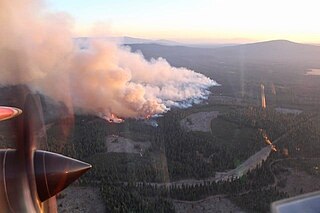
The Milli Fire was a wildfire that burned over 24,000 acres (97 km2) of Oregon forest land during the summer of 2017. The fire began in the Deschutes National Forest on 11 August 2017, the result of a lightning strike. The fire consumed thick forest vegetation southwest of Sisters, Oregon. Most of the burned area was public lands administered by the United States Forest Service, much of it in the Three Sisters Wilderness. Firefighters battled the blaze for over a month. At the peak of the firefighting effort, there were 675 firefighters working on the Milli Fire.

The Ute Park Fire was a wildfire one mile east of Ute Park, New Mexico in the United States. The fire started on May 31, 2018. The cause remains under investigation. The fire burned a total of 36,740 acres (149 km2) and was contained on June 19, 2018. It threatened the communities of Cimarron and Ute Park, with mandatory evacuations in place from June 1 2, respectively, until June 8th: when both were lifted. The fire destroyed 14 buildings and threatened over 750 structures.

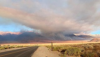
The Georges Fire was a wildfire in Inyo County, California in the United States. The fire was reported on July 8, 2018 in a rural area north of Lone Pine and west of Manzanar. The fire was started by a lightning strike and impacted recreational activities in the Inyo National Forest, as well as the habitat for Sierra Nevada bighorn sheep, an endangered species. The fire burned 2,883 acres (12 km2), before burning out on July 18.

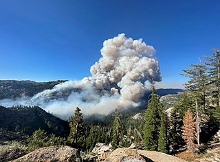
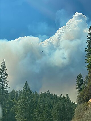
The Ferguson Fire was a major wildfire in the Sierra National Forest, Stanislaus National Forest and Yosemite National Park in California in the United States. The fire was reported on July 13, 2018, burning 96,901 acres (392 km2), before it was 100% contained on August 19, 2018. Interior areas of the fire continued to smolder and burn until September 19, 2018, when InciWeb declared the fire to be inactive. The Ferguson Fire was caused by the superheated fragments of a faulty vehicle catalytic converter igniting vegetation. The fire, which burned mostly in inaccessible wildland areas of the national forest, impacted recreational activities in the area, including in Yosemite National Park, where Yosemite Valley and Wawona were closed. The Ferguson Fire caused at least $171.2 million in damages, with a suppression cost of $118.5 million and economic losses measuring $52.7 million. Two firefighters were killed and nineteen others were injured in the fire.

The Whaleback Fire was a wildfire that burned on Whaleback Mountain in Spaulding, approximately 20 miles northwest of Susanville in Lassen County, California, in the United States. First reported on July 27, 2018, the Whaleback Fire burned 18,703 acres (76 km2), before it was fully contained on August 7. The fire caused evacuations in the community of Spaulding and led to closures of portions of Lassen National Forest.

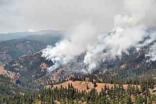
The Lone Fire was a wildfire that burned at Pinnacle Lake in the Modoc National Forest in Modoc County, California in the United States. As of September 13, the fire has burned 5,737 acres (2,322 ha) and is 100% contained.
The Left Hand Fire was a wildfire that burned in the Okanogan Wenatchee National Forest, 17 miles northwest of Naches, in the state of Washington in the United States. The fire, which started July 23, 2019, was caused by a lightning strike. As of September 3, the fire had burned 3,406 acres (1,378 ha) and was 92 percent contained.
The Taboose Fire was a wildfire burning in Inyo National Forest, southwest of Big Pine and northwest of Aberdeen in Inyo County in the state of California, in the United States. The fire started September 4, 2019 and on October 7, it had burned 10,296 acres (4,167 ha) and was 75 percent contained. The cause of the fire was lightning. Select trails, campgrounds and roads in Inyo National Forest, Sequoia National Park and Kings Canyon National Park had been closed due to the fire. The community of Baxter Ranch was under mandatory evacuation.

The Canal Fire was a wildfire that burned Millard County in Utah in the United States. First reported on June 26, 2020, the fire burned 78,065 acres (31,592 ha) on public land, including Fishlake National Forest and land owned by the Bureau of Land Management. Started by a lightning strike, the fire was contained on June 27, only to escape containment on June 28 due to strong winds. The fire led to the mandatory evacuation of Fool Creek Peak and Leamington, Utah. It was contained on July 11, 2020.

The Lake Fire was a wildfire that burned during the 2020 California wildfire season in the Angeles National Forest in Los Angeles County in the state of California in the United States. The fire, which was first reported on August 12, 2020, burned 31,089 acres (12,581 ha) near Lake Hughes. It was fully contained on September 28. The cause of the fire remains unknown. The fire has damaged 3 structures, destroyed 12 structures and 21 outbuildings, and injured 4 firefighters.

The 2020 Loyalton Fire was a large wildfire in Lassen, Plumas and Sierra counties in California and Washoe County in Nevada. After it was ignited by lightning on August 14, 2020, the fire burned 47,029 acres (19,032 ha) in the Tahoe National Forest and the Humboldt-Toiyabe National Forest before it was fully contained on August 26. The Loyalton Fire was notable for generating three fire tornadoes on August 15, necessitating first-of-their-kind warnings by the National Weather Service.

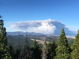
The North Complex Fire was a massive wildfire complex that burned in the Plumas National Forest in Northern California in the counties of Plumas and Butte. 21 fires were started by lightning on August 17, 2020; by September 5, all the individual fires had been put out with the exception of the Claremont and Bear Fires, which merged on that date, and the Sheep Fire, which was then designated a separate incident. On September 8, strong winds caused the Bear/Claremont Fire to explode in size, rapidly spreading to the southwest. On September 8, 2020, the towns of Berry Creek and Feather Falls were immediately evacuated at 3:15 p.m. PDT with no prior warning, By September 9, 2020, the towns of Berry Creek and Feather Falls had been leveled, with few homes left standing. The fire threatened the city of Oroville, before its westward spread was stopped. The fire killed 16 people and injured more than 100. Among the 16 fatalities was a 16-year-old boy. The complex burned an estimated 318,935 acres (129,068 ha), and was 100% contained on December 3. The fire was managed by the U.S. Forest Service in conjunction with Cal Fire, with the primary incident base in Quincy. The North Complex Fire was the sixth-largest in California's modern history, and the deadliest fire in the 2020 California wildfire season.
The 2020 Lassen County wildfire season included seven large wildfires that burned entirely or in part in Lassen County. A total of 203,296 acres (82,271 ha) of land was burned in Lassen County, making it one of the larger clusters of fires in the 2020 California wildfire season.

The 2021 Arizona wildfire season was a series of wildfires that burned across the state of Arizona, United States. Wildfires across the state burned 524,428 acres (212,228 ha) of land in at least 1,773 fires throughout the state, fueled in part by a drought, hot temperatures, and thunderstorms producing dry lightning. At one point in late June, over 20 active wildfires were burning across the state.
The Tamarack Fire was a wildfire that burned 68,637 acres (27,776 ha), primarily in the Mokelumne Wilderness in Alpine County, California, Douglas County, Nevada and Lyon County, Nevada, as part of the 2021 California wildfire season.
The McFarland Fire was a wildfire that burned in the Shasta-Trinity National Forest north of Wildwood in Trinity County, Shasta County, and Tehama County, California in the United States. Started by a lightning strike, the fire was first reported on July 29, 2021 on McFarland Ridge south of Highway 36. As of September 16, 2021, the fire had burned 122,653 acres (49,636 ha) and destroyed 46 structures.
The Beckwourth Complex was a wildfire complex that burned in the Plumas National Forest in Plumas and Lassen counties. The two major fires of the complex, the Dotta Fire and the Sugar Fire, started on June 30 and July 2 northeast of Beckwourth, California. Started by lightning strikes, the two fires collectively burned 105,670 acres (42,763 ha). The complex resulted in the evacuation of numerous residential areas and the closure of portions of Plumas National Forest. In the community of Doyle, California, 33 homes were destroyed.

The Antelope Fire was a wildfire that burned in the Klamath National Forest, the Modoc National Forest, the Shasta-Trinity National Forest, and in Lava Beds National Monument in Siskiyou County, California, in the United States. The fire was started by a lightning strike and was first reported on August 1, 2021. As of October 15, the fire had burned 145,632 acres (58,935 ha).


