
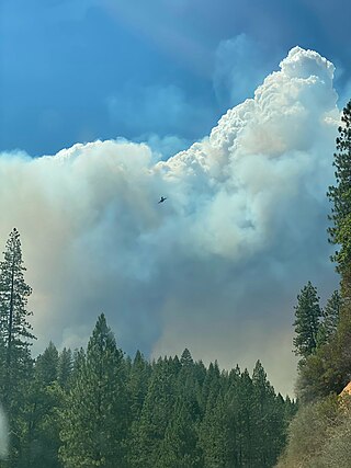
The High Cascades Complex was a group of 20 fires burning in four protected areas in Oregon, in the United States, specifically: Crater Lake National Park, Rogue River – Siskiyou National Forest, Umpqua National Forest, and Fremont–Winema National Forest. The first fire in the complex, the Blanket Creek Fire, was started by a lightning strike on July 29, 2017. In total, the fires have burned 72,309 acres (293 km2) and are 28% contained. The fires are directly impacting the communities of Prospect, Union Creek and Diamond Lake, park headquarters, old growth forests that house endangered species like the spotted owl and volcanic features.

The Milli Fire was a wildfire that burned over 24,000 acres (97 km2) of Oregon forest land during the summer of 2017. The fire began in the Deschutes National Forest on 11 August 2017, the result of a lightning strike. The fire consumed thick forest vegetation southwest of Sisters, Oregon. Most of the burned area was public lands administered by the United States Forest Service, much of it in the Three Sisters Wilderness. Firefighters battled the blaze for over a month. At the peak of the firefighting effort, there were 675 firefighters working on the Milli Fire.

The Whitewater Fire was a wildfire in and near the Mount Jefferson Wilderness, approximately 13 miles east of Detroit, Oregon, United States. The fire, which was caused by a lightning strike and first reported on July 23, 2017, has burned approximately 14,500 acres (59 km2) and is currently no longer active. It is one of eight fires to burn in Willamette National Forest in the Fall of 2017.

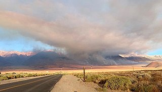
The Georges Fire was a wildfire in Inyo County, California in the United States. The fire was reported on July 8, 2018 in a rural area north of Lone Pine and west of Manzanar. The fire was started by a lightning strike and impacted recreational activities in the Inyo National Forest, as well as the habitat for Sierra Nevada bighorn sheep, an endangered species. The fire burned 2,883 acres (12 km2), before burning out on July 18.

The Red Bank Fire was one of a series of wildfires in Tehama County, California, 25 miles west of Red Bluff. The Red Bank area fire was ignited from a series lightning strikes and erupted out of control on Thursday, September 5, 2019. The blaze, along with the South and Henthrone fires, is burning in a remote location, 30 miles south of Redding, California. The fire was contained on September 13 at 8,838 acres (36 km2). Two structures were destroyed.

The Lone Fire was a wildfire that burned at Pinnacle Lake in the Modoc National Forest in Modoc County, California in the United States. As of September 13, the fire has burned 5,737 acres (2,322 ha) and is 100% contained.
The Taboose Fire was a wildfire burning in Inyo National Forest, southwest of Big Pine and northwest of Aberdeen in Inyo County in the state of California, in the United States. The fire started September 4, 2019 and on October 7, it had burned 10,296 acres (4,167 ha) and was 75 percent contained. The cause of the fire was lightning. Select trails, campgrounds and roads in Inyo National Forest, Sequoia National Park and Kings Canyon National Park had been closed due to the fire. The community of Baxter Ranch was under mandatory evacuation.
The Lime Fire was a wildfire located west of Interstate 5 and north of Highway 96 in the Klamath National Forest's Lime Gulch area in Siskiyou County. The fire was started as the result of a lightning strike during a thunderstorm. As of September 17, the fire has burned 1,862 acres (754 ha) and is 96 percent contained. Evacuation warnings are in place for the area between Ash Creek and Gottsville, warning to take "extreme caution" along Highway 96. Portions of Klamath National Forest are closed due to the fire.

The East Canyon Fire was a wildfire burning in La Plata and Montezuma Counties in Colorado in the United States. The fire was the largest of many small fires started by a lightning storm and was first reported on June 14, 2020. The East Canyon Fire burned 2,905 acres (1,176 ha) and was contained on June 27, 2020. The fire resulted in the closure a portion of Highway 160 and mandatory evacuations of a campground and residences in the area.

The Monarch Fire was a wildfire burning three miles south of Sierra Spirit Ranch in Douglas County, Nevada, in the United States. The fire, which was reported on June 24, 2020, was started by a lightning strike. As of June 28, 2020, it has burned 2,324 acres (940 ha) and was 97 percent contained. The fire is the largest of a handful that resulted after thunderstorms moved through the area.

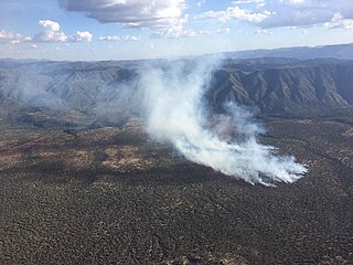
Vics Peak Fire was wildfire that burned in the Apache Kid Wilderness in the Cibola National Forest in New Mexico, United States. First reported on June 15, 2020, the fire was started by a lightning strike. The fire burned 14,624 acres (5,918 ha). It was contained on August 4, 2020. The fire threatened private property, utilities infrastructure, and natural resources in the area, including the habitat of the Mexican spotted owl. It also impacted recreational activities in the area due to trail and campground closures.

The Canal Fire was a wildfire that burned Millard County in Utah in the United States. First reported on June 26, 2020, the fire burned 78,065 acres (31,592 ha) on public land, including Fishlake National Forest and land owned by the Bureau of Land Management. Started by a lightning strike, the fire was contained on June 27, only to escape containment on June 28 due to strong winds. The fire led to the mandatory evacuation of Fool Creek Peak and Leamington, Utah. It was contained on July 11, 2020.
The Polles Fire is a wildfire that burned in the Mazatzal Wilderness Area, 11 miles west of Payson, Arizona, in Tonto National Forest in the United States. The fire, which has burned 628 acres (254 ha), was started by a lightning strike during thunderstorms. The fire is burning in the along the Arizona Trail. As of July 15, it is 92 percent contained. The fire has resulted in the closure of the Tonto Natural Bridge State Park. On July 7, a helicopter working on the fire crashed, resulting in the death of pilot Bryan Boatman.

The 2020 Loyalton Fire was a large wildfire in Lassen, Plumas and Sierra counties in California and Washoe County in Nevada. After it was ignited by lightning on August 14, 2020, the fire burned 47,029 acres (19,032 ha) in the Tahoe National Forest and the Humboldt-Toiyabe National Forest before it was fully contained on August 26. The Loyalton Fire was notable for generating three fire tornadoes on August 15, necessitating first-of-their-kind warnings by the National Weather Service.

The Red Salmon Complex was a wildfire that burned 144,698 acres (58,557 ha) in Humboldt, Trinity, and Siskiyou County in Northern California during the 2020 California wildfire season. On July 27, lightning strikes in the Trinity Alps Wilderness started two fires, the Salmon Fire and the Red Fire, which eventually merged. As the fire grew, hazardous smoke levels surrounded Forks of Salmon, Orleans, Yreka, and Weed.
The Tamarack Fire was a wildfire that burned 68,637 acres (27,776 ha), primarily in the Mokelumne Wilderness in Alpine County, California, Douglas County, Nevada and Lyon County, Nevada, as part of the 2021 California wildfire season.
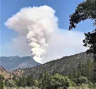
The McFarland Fire was a wildfire that burned in the Shasta-Trinity National Forest north of Wildwood in Trinity County, Shasta County, and Tehama County, California in the United States. Started by a lightning strike, the fire was first reported on July 29, 2021 on McFarland Ridge south of Highway 36. As of September 16, 2021, the fire had burned 122,653 acres (49,636 ha) and destroyed 46 structures.
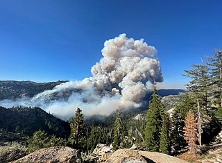
The Monument Fire was a wildfire west of Big Bar in Shasta-Trinity National Forest, Trinity County, California in the United States. The fire, which was started by a lightning strike, was first reported on July 30, 2021. The communities of Big Flat, Big Bar, Del Loma, and Cedar Flat are evacuated. Highway 299 is closed in the area. The fire has destroyed four structures, including three homes. As of the evening of October 27, the fire has burned 223,124 acres (90,295 ha) and is fully contained.

The Antelope Fire was a wildfire that burned in the Klamath National Forest, the Modoc National Forest, the Shasta-Trinity National Forest, and in Lava Beds National Monument in Siskiyou County, California, in the United States. The fire was started by a lightning strike and was first reported on August 1, 2021. As of October 15, the fire had burned 145,632 acres (58,935 ha).

The River Complex 2021 was a wildfire complex burning in Klamath National Forest in Siskiyou County, California in the United States. The complex comprises over 20 wildfires that started as a result of lightning strikes during a series of thunderstorms in late July 2021. As of 25 October 2021, the fire had burned a total of 199,343 acres (80,671 ha) and became 100% contained. The largest fires in the complex were the Haypress–Summer Fire and the Cronan Fire.

