
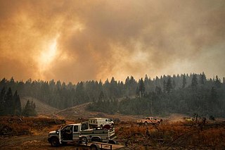
The Carr Fire was a large wildfire that burned in Shasta and Trinity Counties in California, United States. The fire burned 229,651 acres, before it was 100% contained late on August 30, 2018. The Carr Fire destroyed at least 1,604 structures while damaging 277 others, becoming at the time the sixth-most destructive fire in California history, as well as the thirteenth-largest wildfire recorded in modern California history. The Carr Fire cost over $1.659 billion in damages, including $1.5 billion in insured losses and more than $158.7 million in suppression costs. The fire destroyed multiple towns around Whiskeytown Lake. At its height, the fire engaged as many as 4,766 personnel from multiple agencies. The fire was reported on the afternoon of July 23, 2018, at the intersection of Highway 299 and Carr Powerhouse Road, in the Whiskeytown district of the Whiskeytown–Shasta–Trinity National Recreation Area. Coincidental to the name of the incident, the fire was started when a flat tire on a vehicle caused the wheel's rim to scrape against the asphalt, creating sparks that set off the fire.

The Cranston Fire was a wildfire that burned in southwest Riverside County, California, in the United States. The fire was started on July 25, 2018, by Brandon M. McGlover, in an act of arson. The fire burned a total of 13,139 acres (53 km2), before it was fully contained on August 10. The Cranston Fire impacted the communities of Idyllwild and Mountain Center, as well as recreational activities in the Lake Hemet area, San Bernardino National Forest and Mount San Jacinto State Park. Over 7,000 people were evacuated due to the Cranston Fire.
The Tucker Fire was a wildfire that burned near Clear Lake National Wildlife Refuge in Modoc County, California in the United States. The fire ignited on Sunday, July 28, 2019 along Highway 139 and went on to burn an estimated 14,217 acres of land. As of August 15, the fire was 95% contained. Officials say the wildfire was caused by traffic on Highway 139.
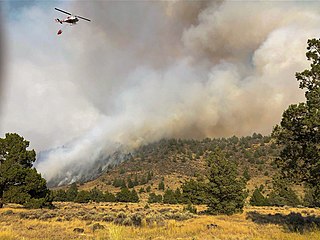
The Walker Fire was a wildfire that burned near Genesee Valley in the Plumas National Forest approximately 11 miles east of the community of Taylorsville in Plumas County, California. The blaze was reported on Wednesday, September 4, 2019 and immediately expanded in size over its several days of burning. The fire actively threatened homes from Genesee Valley to Antelope Road.
The Lime Fire was a wildfire located west of Interstate 5 and north of Highway 96 in the Klamath National Forest's Lime Gulch area in Siskiyou County. The fire was started as the result of a lightning strike during a thunderstorm. As of September 17, the fire has burned 1,862 acres (754 ha) and is 96 percent contained. Evacuation warnings are in place for the area between Ash Creek and Gottsville, warning to take "extreme caution" along Highway 96. Portions of Klamath National Forest are closed due to the fire.

The Canal Fire was a wildfire that burned Millard County in Utah in the United States. First reported on June 26, 2020, the fire burned 78,065 acres (31,592 ha) on public land, including Fishlake National Forest and land owned by the Bureau of Land Management. Started by a lightning strike, the fire was contained on June 27, only to escape containment on June 28 due to strong winds. The fire led to the mandatory evacuation of Fool Creek Peak and Leamington, Utah. It was contained on July 11, 2020.

The Lake Fire was a wildfire that burned during the 2020 California wildfire season in the Angeles National Forest in Los Angeles County in the state of California in the United States. The fire, which was first reported on August 12, 2020, burned 31,089 acres (12,581 ha) near Lake Hughes. It was fully contained on September 28. The cause of the fire remains unknown. The fire has damaged 3 structures, destroyed 12 structures and 21 outbuildings, and injured 4 firefighters.
The August Complex was a massive wildfire that burned in the Coast Range of Northern California, in Glenn, Lake, Mendocino, Tehama, Trinity, and Shasta Counties. The complex originated as 38 separate fires started by lightning strikes on August 16–17, 2020. Four of the largest fires, the Doe, Tatham, Glade, and Hull fires, had burned together by August 30. On September 9, the Doe Fire, the main fire of the August Complex, surpassed the 2018 Mendocino Complex to become both the single-largest wildfire and the largest fire complex in recorded California history. On September 10, the combined Doe Fire also merged with the Elkhorn Fire and the Hopkins Fire, growing substantially in size. By the time it was extinguished on November 12, the August Complex fire had burned a total of 1,032,648 acres (417,898 ha), or 1,614 square miles (4,180 km2), about 1% of California's 100 million acres of land, an area larger than the state of Rhode Island.

The North Complex Fire was a massive wildfire complex that burned in the Plumas National Forest in Northern California in the counties of Plumas and Butte. 21 fires were started by lightning on August 17, 2020; by September 5, all the individual fires had been put out with the exception of the Claremont and Bear Fires, which merged on that date, and the Sheep Fire, which was then designated a separate incident. On September 8, strong winds caused the Bear/Claremont Fire to explode in size, rapidly spreading to the southwest. On September 8, 2020, the towns of Berry Creek and Feather Falls were immediately evacuated at 3:15 p.m. PDT with no prior warning, By September 9, 2020, the towns of Berry Creek and Feather Falls had been leveled, with few homes left standing. The fire threatened the city of Oroville, before its westward spread was stopped. The fire killed 16 people and injured more than 100. Among the 16 fatalities was a 16-year-old boy. The complex burned an estimated 318,935 acres (129,068 ha), and was 100% contained on December 3. The fire was managed by the U.S. Forest Service in conjunction with Cal Fire, with the primary incident base in Quincy. The North Complex Fire was the sixth-largest in California's modern history, and the deadliest fire in the 2020 California wildfire season.

The El Dorado Fire was a wildfire that burned 22,744 acres in San Bernardino and Riverside counties of California from September to November 2020. It was ignited on September 5 by a pyrotechnic device at a gender reveal party in El Dorado Ranch Park; it quickly spread to the San Gorgonio Wilderness Area of the San Bernardino National Forest. Burning over a 71-day period, the fire destroyed 20 structures and resulted in one firefighter fatality, for which the couple hosting the party were charged with involuntary manslaughter.
The Slater and Devil fires were two fires that burned in Northern California and Southern Oregon during the 2020 California wildfire season. The fires burned 166,127 acres (67,229 ha), claimed two lives, injured 12 people, and were 100% contained on November 16. The fires caused some highway reconstructions and forest closures.

The Red Salmon Complex was a wildfire that burned 144,698 acres (58,557 ha) in Humboldt, Trinity, and Siskiyou County in Northern California during the 2020 California wildfire season. On July 27, lightning strikes in the Trinity Alps Wilderness started two fires, the Salmon Fire and the Red Fire, which eventually merged. As the fire grew, hazardous smoke levels surrounded Forks of Salmon, Orleans, Yreka, and Weed.

The Lava Fire was a wildfire that burned 26,409 acres (10,687 ha) along the slopes of Mount Shasta near Weed, California during the 2021 California wildfire season. The fire started on June 25, 2021 and was fully contained on September 3, 2021. The fire destroyed 23 buildings, including 14 houses, as well as damaged an additional building.

The Salt Fire was a wildfire that burned 12,660 acres (5,123 ha) in the Lakehead area north of Shasta Lake in Shasta County, California in the United States during the 2021 California wildfire season. The fire was first reported on Wednesday, June 30, 2021, and it was fully contained on July 19, 2021. The fire destroyed forty-one structures, including twenty-seven residences and fourteen outbuildings, and damaged four additional outbuildings. Although the cause remains under investigation, officials from the Shasta–Trinity National Forest believe that the fire was likely sparked by hot material that fell from a vehicle on Interstate 5 and landed in dry brush next to the freeway.
The Tamarack Fire was a wildfire that burned 68,637 acres (27,776 ha), primarily in the Mokelumne Wilderness in Alpine County, California, Douglas County, Nevada and Lyon County, Nevada, as part of the 2021 California wildfire season.
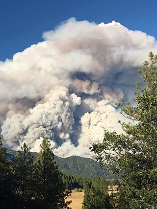
The McFarland Fire was a wildfire that burned in the Shasta-Trinity National Forest north of Wildwood in Trinity County, Shasta County, and Tehama County, California in the United States. Started by a lightning strike, the fire was first reported on July 29, 2021 on McFarland Ridge south of Highway 36. As of September 16, 2021, the fire had burned 122,653 acres (49,636 ha) and destroyed 46 structures.
The Beckwourth Complex was a wildfire complex that burned in the Plumas National Forest in Plumas and Lassen counties. The two major fires of the complex, the Dotta Fire and the Sugar Fire, started on June 30 and July 2 northeast of Beckwourth, California. Started by lightning strikes, the two fires collectively burned 105,670 acres (42,763 ha). The complex resulted in the evacuation of numerous residential areas and the closure of portions of Plumas National Forest. In the community of Doyle, California, 33 homes were destroyed.

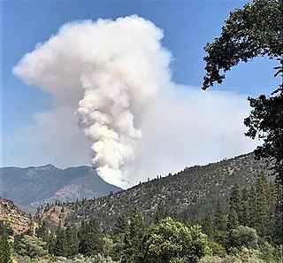
The Antelope Fire was a wildfire that burned in the Klamath National Forest, the Modoc National Forest, the Shasta-Trinity National Forest, and in Lava Beds National Monument in Siskiyou County, California, in the United States. The fire was started by a lightning strike and was first reported on August 1, 2021. As of October 15, the fire had burned 145,632 acres (58,935 ha).

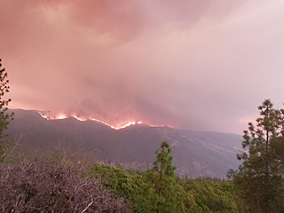
The River Complex 2021 was a wildfire complex burning in Klamath National Forest in Siskiyou County, California in the United States. The complex comprises over 20 wildfires that started as a result of lightning strikes during a series of thunderstorms in late July 2021. As of 25 October 2021, the fire had burned a total of 199,343 acres (80,671 ha) and became 100% contained. The largest fires in the complex were the Haypress–Summer Fire and the Cronan Fire.

The 2021 McCash Fire was a large wildfire in Siskiyou County in Northern California. Part of the 2021 California wildfire season, the fire was ignited by lightning on July 31 and burned 94,962 acres before its containment on October 27. The fire burned within the Klamath National Forest and the Six Rivers National Forest.


