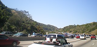
Sepulveda Pass is a low mountain pass through the Santa Monica Mountains in Los Angeles. It is named after the Sepúlveda family of California, a prominent Californio family that owned the land where the pass lies.

The Sayre Fire, also known as the Sylmar Fire, was a November 2008 wildfire that resulted in the loss of 489 residences in Los Angeles, California, United States, the "worst loss of homes due to fire" in the city's history. The fire was first reported at 10:29 p.m. PDT on November 14, 2008, in the Sylmar section of Los Angeles. As of November 20, 2008, the fire was 100% contained, had burned 11,262 acres (46 km2) and destroyed more than 600 structures. The number of homes lost in the Sayre fire exceeded the prior record set in 1961 by the Bel Air Fire which claimed 484 homes. There were no fatalities, just minor injuries to five firefighters and one civilian.
The 1978 Agoura-Malibu firestorm was a firestorm fueled by at least eight significant wildfires in the Los Angeles area on October 23, 1978. At around noon that day, an arsonist started a fire that eventually burned 25,000 acres (10,000 ha) from Cornell to Broad Beach in Malibu. The first fire alarm in Agoura was reported at 12:11 pm, and by 2:30 pm, the fire had reached the Pacific Ocean 13 miles (21 km) south in Malibu. It had been declared a Level 2 fire at 1:57 pm.

The North Fire was a wildfire that occurred in the Mojave Desert near the towns of Victorville and Hesperia, north of San Bernardino and south of Bakersfield, California. The fire began on July 17, 2015. The areas most impacted were adjacent to Interstate 15, where the Cajon Pass passes through the San Bernardino National Forest. The fire spread to 4,250 acres, and burned homes and other buildings, as well as numerous vehicles stranded on the interstate. Seventy-four passenger vehicles and trucks were burned along the highway or in neighboring communities due to the fire. The fire closed Interstate 15, the main highway connecting Southern California with Las Vegas, Nevada, during the first day of the blaze.
The Sherpa Fire was a wildfire that burned in the Santa Ynez Mountains along the Gaviota Coast in the southwestern part of Santa Barbara County, California in June 2016. In a matter of hours the fire spread to over 1,400 acres (570 ha) as the fire was propelled by downslope sundowner winds. This offshore northerly wind contrasts with the more typical onshore flow and sent the fire down the canyons towards the ocean with gusts of over 35 miles per hour (56 km/h). The wildfire resulted in evacuations at two state beach campgrounds and some residences together with intermittent interruption of traffic on a state transportation route.

The Sand Fire was a wildfire in 2016 that burned in the Angeles National Forest, east of the Santa Clarita Valley in Los Angeles County, California. The fire, named for the area's Sand Canyon, was fueled by heavy chaparral and brush.

In terms of property damage, 2017 was the most destructive wildfire season on record in California at the time, surpassed by only the 2018 season and the 2020 season, with a total of 9,560 fires burning 1,548,429 acres (6,266.27 km2) of land, according to the California Department of Forestry and Fire Protection, including five of the 20 most destructive wildland-urban interface fires in the state's history. Throughout 2017, the fires destroyed or damaged more than 10,000 structures in the state, a higher tally than the previous nine years combined. State data showed that the large wildfires killed 47 people – 45 civilians and 2 firefighters – almost higher than the previous 10 years combined. The total property damage and total amount of burned land were both surpassed by the 2018 California wildfires.
The La Tuna Fire was a wildfire that started on September 1, 2017, and burned 7,194 acres (2,911 ha) through the Verdugo Mountains in Los Angeles, California. It led to the destruction of 5 homes and the evacuations of over 300 homes. It was the largest wildfire in the city of Los Angeles in 50 years.

The Canyon Fire 2, also known as the Canyon 2 Fire, was a wildfire that burned in the Anaheim Hills area of the city of Anaheim in Orange County, California. The fast-moving brush fire broke out on October 9, 2017, around 9:45 A.M. PDT near the 91 Freeway and Gypsum Canyon Road. It leaped over the Route 241 toll road, raced up a ridge, and set fire to several homes. In total, about 16,570 were ordered to evacuate their homes in Anaheim, Orange, and Tustin but returned when the evacuation order was lifted on October 12.

The Thomas Fire was a massive wildfire that affected Ventura and Santa Barbara Counties, and one of multiple wildfires that ignited in southern California in December 2017. It burned approximately 281,893 acres before being fully contained on January 12, 2018, making it the largest wildfire in modern California history at the time. It was surpassed by the Ranch Fire, part of the Mendocino Complex, in August 2018. The fire is currently the seventh-largest wildfire in modern California history, as of 2021. The fire was officially declared out on June 1, 2018, after more than two months in which no hotspots were detected. The Thomas Fire destroyed at least 1,063 structures, while damaging 280 others; and the fire caused over $2.2 billion in damages, including $230 million in suppression costs, becoming the seventh-most destructive wildfire in state history at the time. As of August 2020, the Thomas Fire is California's tenth-most destructive wildfire. Ventura's agriculture industry suffered at least $171 million in losses due to the Thomas Fire.

The Creek Fire was a large wildfire that burned in Kagel Canyon and the Angeles National Forest north of Sylmar, a neighborhood in Los Angeles, California, United States, and one of multiple wildfires that broke out across Southern California in December 2017. The Creek Fire burned 15,619 acres (63 km2) and destroyed 123 structures, including 60 homes, before being contained on January 9, 2018, following heavy rainfall from a winter storm. The fire threatened the communities of Santa Clarita, Glendale, Olive View, Lake View Terrace, Sunland-Tujunga, Shadow Hills, Sylmar, Pacoima, Lopez Canyon, and Kagel Canyon, as well as the Olive View–UCLA Medical Center. During the wildfire, 115,000 residents were forced to evacuate their homes.
The Rye Fire was a wildfire that burned in Santa Clarita, California, in the United States, and one of multiple wildfires that broke out across Southern California in December 2017. The fire threatened over 5,000 structures, including Six Flags Magic Mountain, threatened the city of Santa Clarita and impacted traffic on Interstate 5. The Rye Fire burned a total of 6,049 acres (24.48 km2), before it was fully contained on December 12. The fire destroyed six buildings, including minor structures located at the Peter J. Pitchess Detention Center.
A series of 29 wildfires ignited across Southern California in December 2017. Six of the fires became significant wildfires, and led to widespread evacuations and property losses. The wildfires burned over 307,900 acres (1,246 km2), and caused traffic disruptions, school closures, hazardous air conditions, and power outages; over 230,000 people were forced to evacuate. The largest of the wildfires was the Thomas Fire, which grew to 281,893 acres (1,140.78 km2), and became the largest wildfire in modern California history, until it was surpassed by the Ranch Fire in the Mendocino Complex, in the following year.
The Mendocino Complex Fire was a large complex of wildfires that burned in northern California for more than three months in 2018. It consisted of two wildfires, the River Fire and Ranch Fire, which burned in Mendocino, Lake, Colusa, and Glenn Counties in the U.S. State of California, with the Ranch Fire being California's single-largest recorded wildfire at the time until the Dixie Fire in 2021. The Ranch Fire burned eight miles northeast of Ukiah, and the River Fire burned six miles north of Hopland, to the south of the larger Ranch Fire. First reported on July 27, 2018, both fires burned a combined total of 459,123 acres (1,858 km2), before they were collectively 100% contained on September 18, though hotspots persisted until the complex was fully brought under control on January 4, 2019. The Ranch Fire alone burned 410,203 acres (1,660 km2), making it the largest wildfire in modern California history at the time until the August Complex fire that occurred in 2020. The Ranch Fire also surpassed the size of the 315,577-acre Rush Fire, which burned across California and Nevada, as well as the Santiago Canyon Fire of 1889, which was previously believed to have been California's all-time largest wildfire. It also included the Redwood Valley Fire that claimed 8 lives.

The 2019 California wildfire season was a series of wildfires that burned across the U.S. state of California as part of the 2019 wildfire season. By the end of the year, according to Cal Fire and the US Forest Service, 7,860 fires were recorded, totaling an estimated of 259,823 acres of burned land. These fires caused 22 injuries, 3 fatalities, and damaged or destroyed 732 structures. The 2019 California fire season was less active than that of the two previous years, which set records for acreage, destructiveness, and deaths.

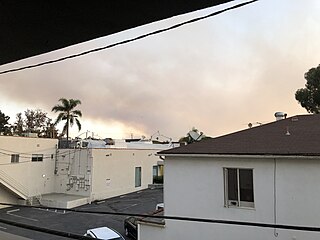
The Palisades Fire was a wildfire that burned in Topanga State Park, in the Pacific Palisades neighborhood of the city of Los Angeles, California on May 14, 2021. The fire burned a total of 1,202 acres (486 ha) and was fully contained on May 26, 2021.
The Getty Fire was a 2019 wildfire that burned 745 acres (301 ha) in Brentwood, Los Angeles, California. The fire was first reported on October 28, 2019 and was contained on November 5, 2019. Thousands of people were forced to flee, 10 homes were destroyed and 15 residences were damaged.
The Soledad Fire was a wildfire that burned 1,525 acres (617 ha) south of Agua Dulce and northeast of Santa Clarita in Los Angeles County, California in the United States during the 2020 California wildfire season. The fire started on July 5, 2020, and caused the complete closure of State Route 14 in both directions throughout the day as the fire grew to 1,498 acres. The fire also at a point threatened over 4,795 structures, although only 9 homes were formally threatened by the direct fireline. The cause of the fire is currently under investigation.

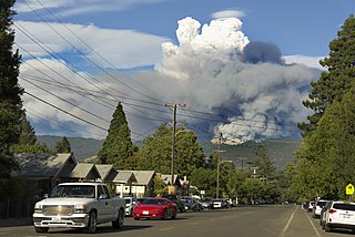
The Lake Fire was a wildfire that burned during the 2020 California wildfire season in the Angeles National Forest in Los Angeles County in the state of California in the United States. The fire, which was first reported on August 12, 2020, burned 31,089 acres (12,581 ha) near Lake Hughes. It was fully contained on September 28. The cause of the fire remains unknown. The fire has damaged 3 structures, destroyed 12 structures and 21 outbuildings, and injured 4 firefighters.
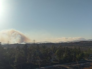
The Route Fire was a wildfire that burned during the 2022 California wildfire season, along Interstate 5 near the community of Castaic in Los Angeles County, California during a dramatic state-wide heatwave in late August and early September, 2022. At least seven firefighters sustained heat-related injuries, while two structures were destroyed and 5,208 acres (2,108 ha) burned.


