
This is a list of properties and districts in Indiana that are listed on the National Register of Historic Places. There are over 1,900 in total. Of these, 39 are National Historic Landmarks. Each of Indiana's 92 counties has at least two listings.

The Mansfield Covered Bridge is a Double Burr Arch double span truss bridge located on Mansfield Road (historic) and Big Raccoon Creek in Mansfield southeast of Rockville in Parke County, Indiana. Built by Joseph J. Daniels in 1867 at a cost of $12,200. At 279 ft (85 m) it is the second longest covered bridge left in Parke County. This Historic Site rest on land provided by Luke Moody, of Parke County, Indiana and is open to the public all year.

The Big Rocky Fork Covered Bridge is located 1 mile (1.6 km) southeast of Mansfield, Indiana, on County Road 720 and about 2 miles (3.2 km) east of State Road 59, in Parke County.

The first Bridgeton covered bridge was a double-span Burr Arch bridge built in 1868 by a crew led by J. J. Daniels. It was closed to traffic in 1967. It was built to replace two prior open wooden bridges that had fallen in. After its destruction by fire, it was replaced in 2006 by a reproduction.

The Nevins Covered Bridge is a single span Burr Arch Truss covered bridge that crosses Little Raccoon Creek on County Road 130 East, just southeast of Catlin, Indiana. It was built in 1920 by Joseph A. Britton and Son. Prior to the reconstruction of the Bridgeton Bridge in 2006, the Nevins Bridge was the newest covered bridge in Parke County.

The Jackson Covered Bridge also known as the Rockport Covered Bridge is located in the 'forgotten town' of Rockport, northwest of Bloomingdale, Parke County, Indiana, USA.
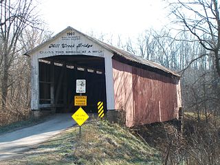
The Mill Creek Covered Bridge also known as "Thompson's Ford Covered Bridge," "Tow Path Covered Bridge," or "Earl Ray Covered Bridge" crosses Wabash Mill Creek (historic) southwest of Tangier, Indiana. It is a single span Burr Arch Truss covered bridge structure that was built by D. M. Brown in 1907.

The Portland Mills Covered Bridge is the second oldest covered bridge in Parke County, Indiana, being built the same year as the Crooks Covered Bridge. It is a single span Burr Arch Truss covered bridge that was built by Henry Wolf in 1856.

The Rush Creek Covered Bridge is south of Tangier, Indiana. The single span Burr Arch covered bridge structure was built by William Hendricks in 1904.
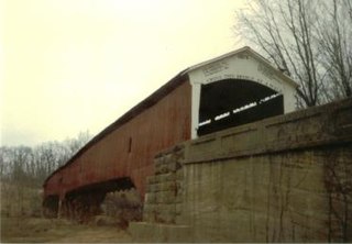
The West Union Covered Bridge formerly carried Tow Path Road over Sugar Creek north-northeast of Montezuma, Indiana. The two-span Burr Arch Truss covered bridge structure was built by Joseph J. Daniels in 1876. It is notable for being the longest standing covered bridge in Parke County, and one of the nation's best-preserved examples of the Burr truss.

The Wilkins Mill Covered Bridge is north of Rockville, Indiana. The single span Burr Arch Truss covered bridge structure was built by William Hendricks in 1906. The bridge is 120 feet (37 m) long, 16 feet (4.9 m) wide, and 13 feet (4.0 m) high.

Blue River Township is one of nine townships in Johnson County, Indiana. As of the 2010 census, its population was 4,936 and it contained 2,096 housing units.

Forsythe Covered Bridge, also known as Forsythe Mill Bridge, is a historic covered bridge located near Rushville, Indiana and/or Gowdy, in Orange Township, Rush County, Indiana. It was built in 1888 by Emmett L. Kennedy. It is a Burr Arch bridge, 196 feet (60 m) long over the Big Flat Rock River. The bridge has rounded arch portals and decorative scrollwork that are signatures of the Kennedy firm.
Huffman Mill Covered Bridge is a historic covered bridge spanning the Anderson River in Anderson Township, Perry County and Harrison Township, Spencer County, Indiana. It was built in 1864–1865, and is a 148 foot long, Burr arch truss wood, stone, and steel bridge. It is one-lane wide and is covered by a gabled, steel roof.

Star Milling and Electric Company Historic District, also known as Star Mill Falls and Star Gristmill, is a historic industrial complex and national historic district located in Lima Township, LaGrange County, Indiana. The district encompasses one contributing building, one contributing site, and two contributing structures. They are a small hydroelectric powerhouse (1929), two dams (1929), and the site of the original 1870 grist mill / hydroelectric generating plant. The old mill generated electric power from 1911 to 1929, and in 1930 the new powerhouse began operation.

Woolery Stone Company is a historic limestone quarry and manufacturing complex located at Bloomington, Monroe County, Indiana. The property includes a variety of buildings, structures, and objects associated with the production of dimensional limestone. These include the limestone faced International Style headquarters building, metal mill office, machine shop, blacksmith shop, limestone storage structure, limestone walls, and the grand scale all metal mill building.

Secrest Ferry Bridge is a historic Pennsylvania through truss bridge located in Bean Blossom Township, Monroe County, Indiana and Wayne Township, Owen County, Indiana. It was built by the Lafayette Engineering Co. and Vincennes Bridge Co. in 1903. It is a single-span bridge of 316 feet in length and spans the West Fork of the White River.

Elm Spring Farm is a historic home and farm located in Jefferson Township, Morgan County, Indiana. The farmhouse was built about 1844, and is a 1+1⁄2-story, single pen log dwelling with a frame kitchen addition. Also on the property are the contributing single corn crib converted to a garage, second single corn crib, privy, brick outdoor fireplace, spring, and sandstone abutments for two absent foot bridges. The building represents an assemblage of pioneer log buildings. During the 1930s, the Civilian Conservation Corps was hired to reforest the farm. The property has also been used as a Girl Scout camp.

Brownsville Covered Bridge was a historic long truss covered bridge located at Brownsville, Union County, Indiana. It was built between 1837 and 1840, and was a single span covered timber bridge. It measured 182 feet (55 m) long and 21 feet 6 inches (6.55 m) wide. The bridge spanned the East Fork of the Whitewater River.

Stockdale Mill, also known as the Roann Roller Mill, is a historic grist mill building located in Paw Paw Township, Wabash County, Indiana. It was built between 1855 and 1857, and is a 3+1⁄2-story, post and beam frame mill building. The mill is powered by a 202 foot long dam that spans the Eel River. Also on the property are the contributing storage building and corn crib. The mill remained in operation until 1964 and was restored in 2002.


