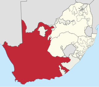
The Province of the Cape of Good Hope, commonly referred to as the Cape Province and colloquially as The Cape, was a province in the Union of South Africa and subsequently the Republic of South Africa. It encompassed the old Cape Colony, as well as Walvis Bay, and had Cape Town as its capital. In 1994, the Cape Province was divided into the new Eastern Cape, Northern Cape and Western Cape provinces, along with part of the North West.

Johan Anthoniszoon "Jan" van Riebeeck was a Dutch navigator and colonial administrator of the Dutch East India Company.

The Karoo is a semi-desert natural region of South Africa. No exact definition of what constitutes the Karoo is available, so its extent is also not precisely defined. The Karoo is partly defined by its topography, geology and climate, and above all, its low rainfall, arid air, cloudless skies, and extremes of heat and cold. The Karoo also hosted a well-preserved ecosystem hundreds of million years ago which is now represented by many fossils.

Mossel Bay Municipality is a municipality located in the Western Cape Province of South Africa. As of 2011 the population was 89,430.
Swartland Municipality is a municipality located in the Western Cape Province of South Africa. Malmesbury is the seat of the municipality. As of 2016, it had a population of 133,762. Its municipality code is WC015.

The Swartberg mountains are a mountain range in the Western Cape province of South Africa. It is composed of two main mountain chains running roughly east–west along the northern edge of the semi-arid Little Karoo. To the north of the range lies the other large semi-arid area in South Africa, the Great Karoo. Most of the Swartberg Mountains are above 2000 m high, making them the tallest mountains in the Western Cape. It is also one of the longest, spanning some 230 km from south of Laingsburg in the west to between Willowmore and Uniondale in the east. Geologically, these mountains are part of the Cape Fold Belt.

Fort Beaufort is a town in the Amatole District of South Africa's Eastern Cape Province, and had a population of 25,668 in 2011. The town was established in 1837 and became a municipality in 1883. The town lies at the confluence of the Kat River and Brak River between the Keiskamma and Great Fish Rivers. Fort Beaufort serves as a mini-'dormitory' for academic staff and students of Fort Hare University, based in the nearby town of Alice, and is also close to Sulphur Springs.

Tamboerskloof is a neighbourhood and suburb of Cape Town, South Africa. It lies on the slopes of Lion's Head and Signal Hill, adjacent to the neighbourhoods of Gardens and Bo-Kaap. Tamboerskloof is one of the contiguous group of neighbourhoods referred to as the City Bowl.

The N12 is a national route in South Africa which runs from George through Beaufort West, Kimberley, Klerksdorp and Johannesburg to eMalahleni.

De Rust is a small village at the gateway to the Klein Karoo, South Africa. The name is Dutch and literally translates to "The Rest", referring to the town's original purpose of being a resting place for settlers en route through the challenging terrain of a nearby Swartberg gorge.

Riebeek-Kasteel is one of the oldest towns in South Africa, situated at 80 km north-east of Cape Town in The Riebeek Valley together with its sister town Riebeek West. They set off in the direction of Paardeberg and on 3 February 1661 they ascended a lonely mountain and came upon the fertile vista of the Riebeek Valley. They named it Riebeek Kasteel, in honor of the Commander.
Henry Fancourt White was a British-born South African colonial assistant surveyor who played a part in construction of the Montagu Pass between George and Oudtshoorn, over the Outeniqua Mountains.

Johann Fran(t)z Drège, commonly referred to by his standard botanical author abbreviation Drège, was a German horticulturalist, botanical collector and explorer of Huguenot descent.

Riebeek West is a small town situated about 75 km north-east of Cape Town and 5 km north of its twin town Riebeek Kasteel in the Swartland area of the Western Cape, South Africa.
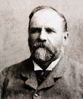
Thomas Charles John Bain was a South African road engineer. As a prolific road building pioneer, Bain was responsible for the planning and construction of more than 900 km of roads and mountain passes, many of them still in use today, over a career spanning from 1848 until 1888. These passes through the mountain ranges between the thin coastal plain and the interior of the former Cape Colony in South Africa, played a major role in opening up the vast hinterland of South Africa.
The Great Brak River is a river in the Western Cape, South Africa. The mouth of the river lies at the town of Great Brak River which falls under the Mossel Bay Municipality. The nearest towns are Mossel Bay, 24 km to the west, and the largest town in the southern Cape George, 34 km to the east by road.

Touws River is a small railway town of 6,800 people in the Western Cape province of South Africa. It is located on the river of the same name, about 160 kilometres (100 mi) north-east of Cape Town. The Touwsrivier CPV Solar Project is located just outside of the town and supplies 50 MW to the national electrical grid.

Great Brak River is a coastal village in the Mossel Bay Local Municipality in the Western Cape province of South Africa. It is a historic village built around the lagoon of the Great Brak River, 17 kilometres (11 mi) north-northeast of the town of Mossel Bay.


