Nebo Center, California

Last updated
Nebo Center, California
Neighborhood of Barstow
Former census-designated place
San Bernardino County California Incorporated and Unincorporated areas Nebo Center Highlighted.svg
Location in San Bernardino County and the state of California
Coordinates: 34°52′15″N116°57′3″W / 34.87083°N 116.95083°W / 34.87083; -116.95083
Country United States
State California
County San Bernardino
City Barstow
Area
  Total2.5 sq mi (6.6 km2)
  Land2.5 sq mi (6.6 km2)
  Water0 sq mi (0 km2)
Population
 (2000)
  Total1,174
  Density469.6/sq mi (177.9/km2)
Time zone UTC-8 (PST)
  Summer (DST) UTC-7 (PDT)
ZIP code
92311
Area codes 442/760
FIPS code 06-50706

Nebo Center is a neighborhood and former census-designated place (CDP) in Barstow, San Bernardino County, California, United States. [1] The population was 1,174 at the 2000 census. The City of Barstow annexed Nebo Center in 2001. [2] The United States Marine Corps Logistics Base Barstow is located at Nebo Center. [3]

Contents

Geography

Nebo Center is located at 34°52′15″N116°57′03″W / 34.870737°N 116.950718°W / 34.870737; -116.950718 . [4]

According to the United States Census Bureau, the CDP has a total area of 2.6 square miles (6.7 km2). 2.5 square miles (6.5 km2) of it is land and 0.04 square miles (0.10 km2) of it (0.78%) is water.

Demographics

As of the census [5] of 2000, there were 1,174 people, 349 households, and 325 families residing in the CDP. The population density was 460.5 inhabitants per square mile (177.8/km2). There were 396 housing units at an average density of 155.3 per square mile (60.0/km2). The racial makeup of the CDP was 60.6% White, 16.3% African American, 1.3% Native American, 3.2% Asian, 1.2% Pacific Islander, 13.0% from other races, and 4.5% from two or more races. Hispanic or Latino of any race were 21.1% of the population.

There were 349 households, out of which 61.6% had children under the age of 18 living with them, 88.0% were married couples living together, 3.7% had a female householder with no husband present, and 6.6% were non-families. 6.3% of all households were made up of individuals, and none had someone living alone who was 65 years of age or older. The average household size was 3.11 and the average family size was 3.22.

In the CDP, the population was spread out, with 34.2% under the age of 18, 25.4% from 18 to 24, 37.2% from 25 to 44, 3.0% from 45 to 64, and 0.2% who were 65 years of age or older. The median age was 23 years. For every 100 females, there were 121.1 males. For every 100 females age 18 and over, there were 131.8 males.

The median income for a household in the CDP was $39,028, and the median income for a family was $34,531. Males had a median income of $23,586 versus $25,903 for females. The per capita income for the CDP was $13,671. About 3.5% of families and 3.2% of the population were below the poverty line, including 3.0% of those under age 18 and none of those age 65 or over.

Politics

In the state legislature, Nebo Center is in the 16th Senate District , represented by Democrat Melissa Hurtado, and in the 33rd Assembly District , represented by Republican Devon Mathis. [6]

In the United States House of Representatives, Nebo Center is in California's 8th congressional district , represented by Democrat John Garamendi. [7]

Related Research Articles

<span class="mw-page-title-main">Moores Mill, Alabama</span> Census-designated place in Alabama, United States

Moores Mill is an unincorporated community and census-designated place (CDP) in Madison County, Alabama, United States, and is included in the Huntsville-Decatur Combined Statistical Area. The population was 6,729 at the 2020 census, up from 5,682 at the 2010 census.

Womens Bay is a census-designated place (CDP) in Kodiak Island Borough, Alaska, United States. At the 2020 census the population was 743, up from 719 in 2010. The name is correctly spelled "Womens", without an apostrophe.

<span class="mw-page-title-main">Riverdale, California</span> Census-designated place in California, United States

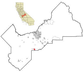
Riverdale is a census-designated place (CDP) in Fresno County, California, United States. The population was 3,153 at the 2010 census, up from 2,416 at the 2000 census. Riverdale is located 23 miles (37 km) south of Fresno, at an elevation of 223 ft (68 m).

<span class="mw-page-title-main">Charter Oak, California</span> Census designated place in California, United States

Charter Oak is a census-designated place (CDP) in Los Angeles County, California, approximately 26 miles (42 km) east of downtown Los Angeles. The population was 9,310 at the 2010 census, up from 9,027 at the 2000 census.

<span class="mw-page-title-main">Blairsden, California</span> Census-designated place in California, United States

Blairsden is a census-designated place (CDP) in Plumas County, California, United States. Blairsden is located 20 miles (32.2 km) east-southeast of Quincy. The population was 39 at the 2010 census, down from 50 at the 2000 census.

<span class="mw-page-title-main">Big River, California</span> Census-designated place in California, United States

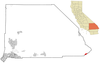
Big River is a census-designated place (CDP) in San Bernardino County, California, United States. The population was 1,327 at the 2010 census, up from 1,266 at the 2000 census.

<span class="mw-page-title-main">Lenwood, California</span> Census-designated place in California, United States

Lenwood is a census-designated place (CDP) in the Mojave Desert near Barstow, in San Bernardino County, California.

<span class="mw-page-title-main">Pine Valley, California</span> Census-designated place in California, United States

Pine Valley is a community and census-designated place (CDP) in the Cuyamaca Mountains of the Mountain Empire area, in southeastern San Diego County, California. The population was 1,510 at the 2010 census, up from 1,501 at the 2000 census.

<span class="mw-page-title-main">Mission Hills, Santa Barbara County, California</span> Census-designated place in the U.S. state of California

Mission Hills is a census-designated place (CDP) in Santa Barbara County, California, a short distance north of Lompoc on Highway 1. The population was 3,576 at the 2010 census, up from 3,142 at the 2000 census.

<span class="mw-page-title-main">Volcano, Hawaii</span> Census-designated place in Hawaii, U.S.

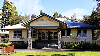
Volcano is a census-designated place (CDP) in Hawaii County, Hawaii, United States located in the District of Puna with a small portion of the CDP in the District of Kaʻū. The population was 2,575 at the 2010 census, up from 2,231 at the 2000 census.

Simsbury Center is a census-designated place (CDP) that consists of the central settlement, and the neighborhoods immediately surrounding it, in the town of Simsbury, Connecticut, in the United States. As of the 2010 census, the CDP had a population of 5,836. The core area of the CDP is listed as the Simsbury Center Historic District on the National Register of Historic Places.

Redbird Smith is a census-designated place (CDP) in Sequoyah County, Oklahoma, United States. It is part of the Fort Smith, Arkansas-Oklahoma Metropolitan Statistical Area. The population was 411 at the 2000 census. It was named for Redbird Smith (Cherokee), who founded the Keetoowah Nighthawk Society in Indian Territory and established a ceremonial ground here for sacred rituals.

Short is a census-designated place (CDP) in Sequoyah County, Oklahoma, United States. It is part of the Fort Smith, Arkansas-Oklahoma Metropolitan Statistical Area. The population was 328 at the 2000 census.

<span class="mw-page-title-main">Altamont, Oregon</span> Unincorporated community in the state of Oregon, United States

Altamont is a census-designated place (CDP) and unincorporated community in Klamath County, Oregon, United States, southeast of Klamath Falls. As of the 2010 Census, the population was 19,257. All mailing addresses in Altamont are Klamath Falls addresses, although Altamont is outside of the city limits of Klamath Falls.

<span class="mw-page-title-main">Gantt, South Carolina</span> Census-designated place in South Carolina, United States

Gantt is a census-designated place (CDP) in Greenville County, South Carolina, United States. The population was 14,229 at the 2010 census. It is part of the Greenville–Mauldin–Easley Metropolitan Statistical Area and a suburb of the city of Greenville.

Wade Hampton is a census-designated place (CDP) in Greenville County, South Carolina, United States. The population was 20,622 at the 2010 census. It is named for American Civil War general and South Carolina governor Wade Hampton.

<span class="mw-page-title-main">Hudson Bend, Texas</span> CDP in Texas, United States

Hudson Bend is a census-designated place (CDP) in Travis County, Texas, United States. The population was 2,981 at the 2010 census.

<span class="mw-page-title-main">Elberta, Utah</span> CDP in Utah, United States

Elberta is a census-designated place (CDP) in Utah County, Utah, United States. It is part of the Provo–Orem Metropolitan Statistical Area. The population was 256 at the 2010 census. It was founded as Mt. Nebo. After the water failed in 1901, most of the early settlers moved away. It was purchased by Matthew B. Whitney, a native of New York, on November 7, 1907, and he renamed it "Elberta" after the peach cultivar.

Antelope Hills is a census-designated place in Natrona County, Wyoming, United States. It is part of the Casper, Wyoming Metropolitan Statistical Area. The population was 97 at the 2010 census.

<span class="mw-page-title-main">Boxford (CDP), Massachusetts</span> Census-designated place in Massachusetts, United States

Boxford is a census-designated place (CDP) in the town of Boxford in Essex County, Massachusetts, United States. The population was 2,339 at the 2010 census.

References

  1. U.S. Geological Survey Geographic Names Information System: Nebo Center, California
  2. "Geographic Boundary Change Notes". U.S. Census Bureau. January 1, 2012. Retrieved January 25, 2012.
  3. "Marine Corps Logistics Base Barstow Map". U.S. Marines Corps . Retrieved 2014-11-16.
  4. "US Gazetteer files: 2010, 2000, and 1990". United States Census Bureau. 2011-02-12. Retrieved 2011-04-23.
  5. "U.S. Census website". United States Census Bureau . Retrieved 2008-01-31.
  6. "Statewide Database". UC Regents. Archived from the original on February 1, 2015. Retrieved November 20, 2014.
  7. "California's 8th Congressional District - Representatives & District Map". Civic Impulse, LLC.