George Edward Kessler was an American pioneer city planner and landscape architect.
Charles Mulford Robinson (1869–1917) was a journalist and a writer who became famous as a pioneering urban planning theorist. He has the greatest influence as a missionary for urban beautification. He was the first Professor for Civic Design at University of Illinois at Urbana-Champaign, which was only one of two universities offering courses in urban planning at the time, the other being Harvard.

The Williams–Woodland Park Local Historic District was established in 1985 and is a national historic district located at Fort Wayne, Indiana. The district encompasses 287 contributing buildings in a predominantly residential section of Fort Wayne located approximately one mile south of downtown. The area was developed from about 1875 to 1940, and includes notable examples of Colonial Revival, Prairie School, and Queen Anne style residential architecture.

Fletcher Place is a historic district and neighborhood in the city of Indianapolis, Indiana named after Calvin Fletcher, a prominent local banker, farmer and state senator.

Chatham–Arch is a neighborhood located immediately east of Downtown Indianapolis, Indiana, United States. This neighborhood is one of the oldest in Indianapolis, dating back to the mid 19th century. Chatham–Arch contains many of Indianapolis's historic homes.

The Washington Park Historic District is a national historic district located in Indianapolis, Indiana. It was listed on the National Register of Historic Places on June 24, 2008. It comprises nearly 60 acres (240,000 m2) and is located 4 miles (6.4 km) north of downtown Indianapolis, in the south-central part of the Meridian-Kessler neighborhood. The district includes all properties south of 43rd Street and north of 40th Street, and west of Central Avenue and east of the alley running north and south between Pennsylvania and Meridian Streets; Washington Boulevard runs north-south through the center of the district. It includes 110 contributing buildings, ranging mostly from mansions to small bungalows, and three non-contributing buildings.
The Forest Park Boulevard Historic District is a national historic district located at Fort Wayne, Indiana. The district encompasses 93 contributing buildings, 1 contributing site, and 15 contributing objects in a predominantly residential section of Fort Wayne. The area was developed from about 1890 to 1955, and includes notable examples of Colonial Revival and Tudor Revival style architecture. The district features ornamental light posts / streetlights and stone entry markers.

Oliver Johnson's Woods is a historic district and neighborhood on the northern side of Indianapolis, Indiana, United States. Located in southern Washington Township, the district occupies the site of what was once the family farm of Oliver Johnson. Born on the present site of the Indiana State Fairgrounds, Johnson grew up in a pioneer family that lived on the edge of the state capital city. Upon attaining adulthood, he bought property a short distance to the west, to which he moved in 1846. Here, he built a larger farmhouse in 1862, and he tilled the soil for most of the rest of his life. As Indianapolis grew northward, it reached the Johnson farm in the early twentieth century; the aged farmer and his sons saw the city's growth as an opportunity for financial gain, and in 1905 they announced the platting of 0.25 square miles (0.65 km2) of their property into individual lots. They chose an advantageous time to sell their property; as the new residents began to build their homes, an interurban railway was built along College Avenue on the district's western side that connected downtown with Broad Ripple. Many prosperous businessmen were attracted by the development's large lots and wooded streets; the city annexed Oliver Johnson's Woods in 1912, and by the outbreak of World War II, the streets were filled with large houses built in a wide variety of architectural styles. These early residents came from many different ethnicities: European immigrants were becoming more prosperous and leaving their ethnic enclaves, and new neighborhoods such as Oliver Johnson's Woods appealed to them. Among the neighborhood's leading residents was a colony of Jews of German descent.

Culver Historic District is a national historic district located at Evansville, Indiana. The neighborhood is all residential, and unlike most of the rest of the city, the lots are not laid out on a grid. Most of the houses are on a lot previously part of the farm owned by Robert Parrett, a native of England who settled in Evansville and built a house near the intersection of Madison Avenue and Parrett Street. Eventually Robert Parrett would become the first Methodist minister in Evansville and helped found Trinity Methodist church, which he served until his death in 1860. His heirs divided up the plat in 1863.

West End Historic District, also known as the West Central Neighborhood, is a national historic district located at Fort Wayne, Indiana. The district encompasses 596 contributing buildings in a predominantly residential section of Fort Wayne. The area was developed from about 1840 to 1935, and includes notable examples of Greek Revival, Late Victorian, and Bungalow / American Craftsman style residential architecture. It is the location of numerous middle- and upper-income residential buildings, the University of Saint Francis Performing Arts Center, and Trinity English Lutheran Church—the last designed by Bertram Grosvenor Goodhue.

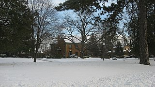
Southwood Park Historic District is a national historic district located at Fort Wayne, Indiana. The district encompasses 1,889 contributing buildings, 1 contributing site, 4 contributing structures, and 1 contributing object in a predominantly residential section of Fort Wayne. The area was developed between about 1906 and 1965, and includes notable examples of Colonial Revival, Tudor Revival, Mission Revival, and Bungalow / American Craftsman style residential architecture. Its development is directly related to the implementation of the 1912 plan for Parks and Boulevards for the city of Fort Wayne by city planner and landscape architect George Kessler.

St. Vincent Villa Historic District is a national historic district located at Fort Wayne, Indiana. The district encompasses nine contributing buildings and one contributing site associated with a Catholic orphanage. The buildings were constructed between 1932 and 1950–1951, and include notable examples of Mission Revival, Romanesque Revival, and Bungalow / American Craftsman style institutional architecture. They include the Main Building (1932), four cottages, the Boiler House (1932), and two bungalows. The property was sold by the Roman Catholic Diocese of Fort Wayne–South Bend to the YWCA of Fort Wayne in the 1970s.

William C. and Clara Hagerman House is a historic home located at Fort Wayne, Indiana. It was built about 1923, and is a two-story, side gabled, American Craftsman style brick dwelling. The house features wide, overhanging eaves with decorative, exposed triangular braces and leaded glass and colored glass windows. Also on the property is a contributing garage.
Wildwood Park Historic District is a national historic district located at Fort Wayne, Indiana. The district encompasses 190 contributing buildings, 2 contributing sites, and 1 contributing structure in a predominantly residential section of Fort Wayne. The area was developed from about 1914 to 1955, and includes notable examples of Colonial Revival, Tudor Revival, and Bungalow / American Craftsman style residential architecture. The neighborhood was platted and designed by noted landscape architect Arthur Asahel Shurcliff.

Lafayette Place Historic District is a national historic district located at Fort Wayne, Indiana. The district encompasses 582 contributing buildings, 1 contributing site, 1 contributing structure, and 1 contributing object in a predominantly residential section of Fort Wayne. The area was developed from about 1915 to 1963, and includes notable examples of Colonial Revival, Tudor Revival, and Bungalow / American Craftsman style residential architecture. The neighborhood was platted and designed by noted landscape architect Arthur Asahel Shurcliff.

Foster Park Neighborhood Historic District is a national historic district located at Fort Wayne, Indiana. The district encompasses 222 contributing buildings in a predominantly residential section of Fort Wayne. The area was developed from about 1924 to 1963, and includes notable examples of Colonial Revival, Tudor Revival, and Bungalow / American Craftsman style residential architecture. The neighborhood was platted and designed by Hilgeman & Schaaf.

Brookview–Irvington Park Historic District is a national historic district located at Fort Wayne, Indiana. The district encompasses 423 contributing buildings and 1 contributing site in a predominantly residential section of Fort Wayne. The area was developed from about 1906 to 1965, and includes notable examples of Colonial Revival, Tudor Revival, and Bungalow / American Craftsman style residential architecture. A section of the neighborhood was platted and designed by noted landscape architect Arthur Asahel Shurcliff.

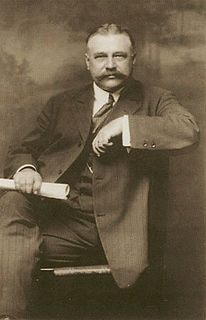
Fort Wayne Park and Boulevard System Historic District is a national historic district located at Fort Wayne, Indiana. The district encompasses 34 contributing buildings, 61 contributing sites, 70 contributing structures, and 15 contributing objects in 11 public parks, four parkways, and ten boulevards associated with the parkway and boulevard system in Fort Wayne. The system was originally conceived in 1909 by Charles Mulford Robinson (1869–1917) and further developed and refined by noted landscape architect and planner George Kessler (1862-1923) in 1911–1912. The buildings reflect Classical Revival and Bungalow / American Craftsman style architecture. Later additions and modifications include those by noted landscape architect Arthur Asahel Shurcliff.

The Kensington Boulevard Historic District is a historic district on the National Register of Historic Places in Fort Wayne, Indiana, added in 2019. The district contains more than 170 homes built between 1917 and 1955, with one home dating to approximately 1870. The boundaries of the district stretch from Niagra Drive along Maumee River in the south to East State Boulevard, its present northern boundary. To the west, it is bounded by the North Anthony Boulevard Historic District, and to the east, by Pemberton Drive. The entire length of this portion of Kengsington features esplanades planted with trees. The district was platted in two separate phases, the south phase in 1917 and the north phase in 1921, on a grid plan.

The Lakeside Historic District is a historic district on the National Register of Historic Places in Fort Wayne, Indiana, added in 2018.


