Pagsanjan

Last updated
Pagsanjan
Pinagsangahan
Municipality of Pagsanjan
Pagsanjanjf4165 14.JPG
Downtown area
Pagsanjan flag.png
Pagsanjan Laguna.png
Nicknames: 
  • Tourist Capital of Laguna
  • Athens of Laguna
  • Home of Our Lady of Guadalupe de Filipinas
Motto(s): 
Negosyo Palakasin, Trabaho Padamihin AASENSO PAGSANJAN!
Ph locator laguna pagsanjan.svg
Map of Laguna with Pagsanjan highlighted
OpenStreetMap
Pagsanjan
Philippines location map (square).svg
Red pog.svg
Pagsanjan
Location within the Philippines
Coordinates: 14°16′N121°27′E / 14.27°N 121.45°E / 14.27; 121.45
Country Philippines
Region Calabarzon
Province Laguna
District 4th district
Founded December 12, 1668
Barangays 16 (see Barangays)
Government
[1]
  Type Sangguniang Bayan
   Mayor Cesar V. Areza
   Vice Mayor Terryl O. Gamit-Talabong
   Representative Maria Jamina Katherine B. Agarao
   Municipal Council
Members
   Electorate 31,210 voters
Area
[2]
  Total26.36 km2 (10.18 sq mi)
Elevation
149 m (489 ft)
Highest elevation
492 m (1,614 ft)
Lowest elevation
1 m (3 ft)
Population
 (2020 census) [3]
  Total44,327
  Density1,700/km2 (4,400/sq mi)
   Households
11,404
Economy
   Income class 3rd municipal income class
   Poverty incidence
2.34
% (2018) [4]
   Revenue 190.6 million (2020)
   Assets 258.1 million (2020)
   Expenditure 162.7 million (2020)
   Liabilities 49.97 million (2020)
Service provider
  ElectricityFirst Laguna Electric Cooperative (FLECO)
Time zone UTC+8 (PST)
ZIP code
4008
PSGC
IDD : area code +63(0)49
Native languages Tagalog
Website www.pagsanjan.gov.ph

Pagsanjan (pronounced PAG-sang-han), officially the Municipality of Pagsanjan (Tagalog : Bayan ng Pagsanjan), is a 3rd class municipality in the province of Laguna, Philippines. According to the 2020 census, it has a population of 44,327 people. [3]

Contents

Situated 4 kilometres (2.5 mi) from Santa Cruz and 91 kilometres (57 mi) southeast of Manila, this town can reach via Manila East Road or Slex. Pagsanjan is the tourist capital of Laguna and is the home of the Bangkero Festival held every March. The bangkeros are tour guides who steer boats along the river to Pagsanjan Falls (also called Magdapio Falls), for which the town is well known but is actually in neighboring Cavinti. [5] [6]

Pagsanjan was the capital of the province of Laguna for 170 years (1688–1858) during which the town prospered as the commercial, cultural and learning center of the province. [7]

Etymology

Pagsanjan is located in the riparian delta formed by the confluence of the Balanac and Bumbungan rivers. Originally called Pinágsangahán ("branching" or "juncture"), this was shortened to "Pagsanjan" by early Spanish colonists because they found the name very difficult to pronounce.

History

Old Town Gate Arch of Pagsanjan.jpg
Old Town Gate

Pagsanjan was originally a barrio of Lumban. In 1668, eight Japanese and Chinese traders, who were highly impressed by the strategic location of the barrio at the juncture of Balanac and Bumbungan, rivers founded the town. They established a trading settlement and engaged in the betel nut industry. In time, the barrio became the flourishing trading center of eastern Laguna and attracted families from the surrounding communities of Cavinti and Pila. On December 12, 1668, then-Governor-General Juan Manuel de la Peña Bonifaz issued a decree elevating its status to a town. In 1688, Pagsanjan replaced Bay as the capital of the province. It remained such until 1858, during which it bloomed as the cultural and commercial center of the province. [8]

List of mayors

Geography

Pagsanjan Falls Pagsanjan Falls.jpg
Pagsanjan Falls

Pagsanjan has a land area of 26.4 square kilometres. It is bounded on the east by the Balubad Mountain; on the west by the capital town of Santa Cruz; on the north by the San Isidro Hill and Laguna de Bay; on the north-east by the town of Lumban; on the southeast by the towns of Cavinti and Luisiana; on the south by Mount Banahaw; and on the south-west by the town of Magdalena.

Barangays

Pagsanjan is politically subdivided into 16 barangays. [19] Each barangay consists of puroks and some have sitios.

Political map of Pagsanjan. Pagsanjan Map Wiki.png
Political map of Pagsanjan.
  • Anibong
  • Biñan
  • Buboy
  • Cabanbanan
  • Calusiche
  • Dingin
  • Lambac
  • Layugan
  • Magdapio
  • Maulawin
  • Pinagsanjan
  • Barangay I (Poblacion)
  • Barangay II (Poblacion)
  • Sabang
  • Sampaloc
  • San Isidro

Climate

Climate data for Pagsanjan, Laguna
MonthJanFebMarAprMayJunJulAugSepOctNovDecYear
Mean daily maximum °C (°F)26
(79)
27
(81)
29
(84)
31
(88)
31
(88)
30
(86)
29
(84)
29
(84)
29
(84)
29
(84)
28
(82)
26
(79)
29
(84)
Mean daily minimum °C (°F)22
(72)
22
(72)
22
(72)
23
(73)
24
(75)
25
(77)
24
(75)
24
(75)
24
(75)
24
(75)
24
(75)
23
(73)
23
(74)
Average precipitation mm (inches)58
(2.3)
41
(1.6)
32
(1.3)
29
(1.1)
91
(3.6)
143
(5.6)
181
(7.1)
162
(6.4)
172
(6.8)
164
(6.5)
113
(4.4)
121
(4.8)
1,307
(51.5)
Average rainy days13.49.39.19.819.122.926.624.925.021.416.516.5214.5
Source: Meteoblue [20]

Demographics

Population census of Pagsanjan
YearPop.±% p.a.
1903 6,361    
1918 7,538+1.14%
1939 8,865+0.78%
1948 9,282+0.51%
1960 10,691+1.18%
1970 14,556+3.13%
1975 16,188+2.15%
1980 19,489+3.78%
1990 25,024+2.53%
1995 28,999+2.80%
2000 32,622+2.56%
2007 35,944+1.35%
2010 39,313+3.31%
2015 42,164+1.34%
2020 44,327+0.99%
Source: Philippine Statistics Authority [21] [22] [23] [24]

In the 2020 census, the population of Pagsanjan was 44,327 people, [3] with a density of 1,700 inhabitants per square kilometre or 4,400 inhabitants per square mile.

Economy

Culture

Pagsanjan March

The official song of the town is the "Pagsanjan March". The anthem was composed by Rogel Taiño, a native of Pagsanjan.

Notable personalities

See also

Related Research Articles

<span class="mw-page-title-main">Laguna (province)</span> Province in Calabarzon, Philippines

Laguna, officially the Province of Laguna, is a province in the Philippines located in the Calabarzon region in Luzon. Its capital is Santa Cruz while its largest city is the City of Calamba and the province is situated southeast of Metro Manila, south of the province of Rizal, west of Quezon, north of Batangas and east of Cavite. Laguna hugs the southern shores of Laguna de Bay, the largest lake in the country. As of the 2020 census, the province's total population is 3,382,193. It is the seventh richest province in the country in 2016.

<span class="mw-page-title-main">Calabarzon</span> Administrative region of the Philippines

Calabarzon, sometimes referred to as Southern Tagalog and designated as Region IV‑A, is an administrative region in the Philippines. The region comprises five provinces: Batangas, Cavite, Laguna, Quezon, and Rizal; and one highly urbanized city, Lucena. It is the most populous region in the Philippines according to the Philippine Statistics Authority (PSA), having over 16.1 million inhabitants in 2020, and is also the country's second most densely populated after the National Capital Region. It is situated southeast of Metro Manila, and is bordered by Manila Bay and South China Sea to the west, Lamon Bay and the Bicol Region to the east, Tayabas Bay and the Sibuyan Sea to the south, and Central Luzon to the north. It is home to places like Mount Makiling near Los Baños, Laguna, and Taal Volcano in Batangas.

<span class="mw-page-title-main">Cavinti</span> Municipality in Laguna, Philippines

Cavinti, officially the Municipality of Cavinti, is a 3rd class municipality in the province of Laguna, Philippines. According to the 2020 census, it has a population of 23,980 people.

<span class="mw-page-title-main">Majayjay</span> Municipality in Laguna, Philippines

Majayjay, officially designated as the Municipality of Majayjay, is a 4th-class municipality in the province of Laguna, Philippines. As of the 2020 census, the city has a population of 27,893 residents.

<span class="mw-page-title-main">Liliw</span> Municipality in Laguna, Philippines

Liliw, officially the Municipality of Liliw, is a 4th class municipality in the province of Laguna, Philippines. According to the 2020 census, it has a population of 39,491 people.

<span class="mw-page-title-main">Alaminos, Laguna</span> Municipality in Laguna, Philippines

Alaminos, officially the Municipality of Alaminos, is a 3rd class municipality in the province of Laguna, Philippines. According to the 2020 census, it has a population of 51,619 people.

<span class="mw-page-title-main">Biñan</span> Component city in Laguna, Philippines

Biñan, officially the City of Biñan, is a 1st class component city in the province of Laguna, Philippines. According to the 2020 census, it has a population of 407,437 people.

<span class="mw-page-title-main">Calauan</span> Municipality in Laguna, Philippines

Calauan, officially the Municipality of Calauan, is a 2nd class municipality in the province of Laguna, Philippines. The municipality has a land area of 25.25 square miles which constitutes 3.41% of Laguna's total area. According to the 2020 census, it has a population of 87,693 people.

<span class="mw-page-title-main">Famy</span> Municipality in Laguna, Philippines

Famy, officially the Municipality of Famy, is a 5th class municipality in the province of Laguna, Philippines. According to the 2020 census, it has a population of 16,791 people, making it the least populated municipality in the province.

<span class="mw-page-title-main">Kalayaan, Laguna</span> Municipality in Laguna, Philippines

Kalayaan, officially the Municipality of Kalayaan, is a 3rd class municipality in the province of Laguna, Philippines. According to the 2020 census, it has a population of 24,755 people.

<span class="mw-page-title-main">Luisiana</span> Municipality in Laguna, Philippines

Luisiana, officially the Municipality of Luisiana, is a 4th class municipality in the province of Laguna, Philippines. According to the 2020 census, it has a population of 20,859 people.

<span class="mw-page-title-main">Lumban</span> Municipality in Laguna, Philippines

Lumban, officially the Municipality of Lumban, is a 3rd class municipality in the province of Laguna, Philippines. According to the 2020 census, it has a population of 32,330 people.

<span class="mw-page-title-main">Paete</span> Municipality in Laguna, Philippines

Paete, officially the Municipality of Paete, is a 4th class municipality in the province of Laguna, Philippines. According to the 2020 census, it has a population of 24,945 people.

<span class="mw-page-title-main">Pangil</span> Municipality in Laguna, Philippines

Pangil, officially the Municipality of Pangil, is a 4th class municipality in the province of Laguna, Philippines. According to the 2020 census, it has a population of 25,026 people.

<span class="mw-page-title-main">Santa Cruz, Laguna</span> Capital of Laguna, Philippines

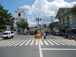
Santa Cruz, officially the Municipality of Santa Cruz, is a 1st class municipality and capital of the province of Laguna, Philippines. According to the 2020 census, it has a population of 123,574 people.

<span class="mw-page-title-main">Siniloan</span> Municipality in Laguna, Philippines

Siniloan, officially the Municipality of Siniloan, is a 2nd class municipality in the province of Laguna, Philippines. According to the 2020 census, it has a population of 39,460 people.

<span class="mw-page-title-main">General Mariano Alvarez</span> Municipality in Cavite, Philippines

General Mariano Alvarez, officially the Municipality of General Mariano Alvarez and often shortened as GMA, is a 1st class municipality in the province of Cavite, Philippines. According to the 2020 census, it has a population of 172,433 people.

<span class="mw-page-title-main">Cardona, Rizal</span> Municipality in Rizal, Philippines

Cardona, officially the Municipality of Cardona, is a 3rd class municipality in the province of Rizal, Philippines. According to the 2020 census, it has a population of 50,143 people.

<span class="mw-page-title-main">Jalajala</span> Municipality in Rizal, Philippines

Jalajala, officially the Municipality of Jalajala, is a 4th class municipality in the province of Rizal, Philippines. According to the 2020 census, it has a population of 34,017 people.

<span class="mw-page-title-main">Pagsanjan Falls</span> Waterfall in Laguna, Philippines

Pagsanjan Falls, also known as Cavinti Falls, is one of the most famous waterfalls in the Philippines. Located in the province of Laguna, the falls is one of the major tourist attractions of the region. The three-drop waterfall is reached by a river trip on dugout canoe, known locally as "Shooting the Rapids", originating from the municipality of Pagsanjan. The falls can also be reached from the top by a short hike from Cavinti.

References

  1. Municipality of Pagsanjan | (DILG)
  2. "2015 Census of Population, Report No. 3 – Population, Land Area, and Population Density" (PDF). Philippine Statistics Authority. Quezon City, Philippines. August 2016. ISSN   0117-1453. Archived (PDF) from the original on May 25, 2021. Retrieved July 16, 2021.
  3. 1 2 3 Census of Population (2020). "Region IV-A (Calabarzon)". Total Population by Province, City, Municipality and Barangay. Philippine Statistics Authority . Retrieved 8 July 2021.
  4. "PSA Releases the 2018 Municipal and City Level Poverty Estimates". Philippine Statistics Authority. 15 December 2021. Retrieved 22 January 2022.
  5. "Pagsanjan, Laguna – The Tourist Capital of Laguna" . Retrieved 2020-01-17.
  6. "The Philippine Star" . Retrieved 2020-01-17.
  7. Pagsanjan Official Site Archived 2011-07-27 at the Wayback Machine
  8. "Pagsanjan, Laguna – The Tourist Capital of Laguna" . Retrieved January 17, 2020.
  9. Landingin, Roel (2017). Public Choice: The Life of Armand V. Fabella in Government and Education. Mandaluyong, Philippines: Anvil Publishing, Inc. ISBN   9786214201457.
  10. Report of the Commission on Elections to the President of the Philippines and the Congress on the Manner the Election was Held on November 10, 1959. Commission on Elections. 1960. p. 380. Retrieved April 26, 2024.
  11. Urera, Vivencio, ed. (1966). "Municipal Officials". Philippine Government Elective Officials: Semi-pictorial Directory. Manila, Philippines: Urema Publishing Co., Ltd. p. 183. Retrieved April 26, 2024.
  12. Commission on Elections (1969). "List of municipal and municipal district officials elected...". Report of the Commission on Elections to the President of the Philippines and the Congress. Manila, Philippines: Bureau of Printing. p. 370. Retrieved November 12, 2023.
  13. "Rebels kidnap 2 more bets". Manila Standard . Standard Publications, Inc. December 18, 1987. p. 8. Retrieved April 26, 2024.
  14. Juvida, Sol (March 11, 1988). "Pagsanjan: Happy, angry, sad". Manila Standard . Standard Publications, Inc. p. 8. Retrieved April 26, 2024.
  15. "Newly built pathway". Manila Standard . Kamahalan Publishing Corp. September 18, 1997. p. 18. Retrieved April 26, 2024.
  16. Esplanada, Jerry; Nocum, Armand N. (October 27, 2000). "Pagsanjan Palace: Who paid the bill?". Philippine Daily Inquirer . The Philippine Daily Inquirer, Inc. p. A18. Retrieved April 26, 2024.
  17. "Political dynasties win some, lose some". Philippine Daily Inquirer . The Philippine Daily Inquirer, Inc. May 12, 2016. Retrieved April 26, 2024.
  18. Nazario, Dhel; Damicog, Jeffrey G.; Panaligan, Rey G. (May 14, 2019). "Ejercito-Estrada clan takes a beating in the polls". Manila Bulletin . Manila Bulletin Publishing Corporation. Retrieved April 26, 2024.
  19. "Province: Laguna". PSGC Interactive. Quezon City, Philippines: Philippine Statistics Authority . Retrieved 12 November 2016.
  20. "Pagsanjan: Average Temperatures and Rainfall". Meteoblue. Retrieved May 11, 2020.
  21. Census of Population (2015). "Region IV-A (Calabarzon)". Total Population by Province, City, Municipality and Barangay. Philippine Statistics Authority . Retrieved 20 June 2016.
  22. Census of Population and Housing (2010). "Region IV-A (Calabarzon)" (PDF). Total Population by Province, City, Municipality and Barangay. National Statistics Office . Retrieved 29 June 2016.
  23. Censuses of Population (1903–2007). "Region IV-A (Calabarzon)". Table 1. Population Enumerated in Various Censuses by Province/Highly Urbanized City: 1903 to 2007. National Statistics Office.{{cite encyclopedia}}: CS1 maint: numeric names: authors list (link)
  24. "Province of Laguna". Municipality Population Data. Local Water Utilities Administration Research Division. Retrieved 17 December 2016.
  25. "Poverty incidence (PI):". Philippine Statistics Authority. Retrieved December 28, 2020.
  26. "Estimation of Local Poverty in the Philippines" (PDF). Philippine Statistics Authority. 29 November 2005.
  27. "2003 City and Municipal Level Poverty Estimates" (PDF). Philippine Statistics Authority. 23 March 2009.
  28. "City and Municipal Level Poverty Estimates; 2006 and 2009" (PDF). Philippine Statistics Authority. 3 August 2012.
  29. "2012 Municipal and City Level Poverty Estimates" (PDF). Philippine Statistics Authority. 31 May 2016.
  30. "Municipal and City Level Small Area Poverty Estimates; 2009, 2012 and 2015". Philippine Statistics Authority. 10 July 2019.
  31. "PSA Releases the 2018 Municipal and City Level Poverty Estimates". Philippine Statistics Authority. 15 December 2021. Retrieved 22 January 2022.
  32. "Philippine Institute for Development Studies". pids.gov.ph. Retrieved 2020-04-20.
Preceded by
Bay
Capital of Laguna
1688-1858
Succeeded by