Pleasant Run, Ohio

Last updated

Pleasant Run, Ohio
Hamilton County Ohio Incorporated and Unincorporated areas Pleasant Run highlighted.svg
Location in Hamilton County and the state of Ohio
Coordinates: 39°17′34″N84°34′33″W / 39.29278°N 84.57583°W / 39.29278; -84.57583
Country United States
State Ohio
County Hamilton
Township Colerain
Area
[1]
  Total2.07 sq mi (5.36 km2)
  Land2.07 sq mi (5.36 km2)
  Water0.00 sq mi (0.00 km2)
Elevation
[2]
873 ft (266 m)
Population
 (2020)
  Total4,861
  Density2,347.18/sq mi (906.14/km2)
Time zone UTC-5 (Eastern (EST))
  Summer (DST) UTC-4 (EDT)
FIPS code 39-63604 [3]
GNIS feature ID2393190 [2]

Pleasant Run is a census-designated place (CDP) in Colerain Township, Hamilton County, Ohio, United States. The population was 4,861 at the 2020 census.

Contents

History

Pleasant Run takes its name from a stream. [4] A Pleasant Run Post Office was established on March 4, 1846, and discontinued on February 15, 1907, with mail service being transferred to the post office in Mount Healthy. [5] Pleasant Run was described in the 1940 American Guide Series as a rural village with 39 inhabitants. [6]

Geography

According to the United States Census Bureau, the CDP has a total area of 2.1 square miles (5.4 km2), all land.

Pleasant Run Farm is located to the east in neighboring Springfield Township.

Demographics

Historical population
CensusPop.Note
2020 4,861
U.S. Decennial Census [7]

2020 census

As of the census of 2020, there were 4,861 people living in the CPD, for a population density of 2,347.18 people per square mile (906.14/km2). There were 1,816 housing units. The racial makeup of the CPD was 68.2% White, 19.4% Black or African American, 0.5% Native American, 3.1% Asian, 0.1% Pacific Islander, 1.9% from some other race, and 6.9% from two or more races. 3.4% of the population were Hispanic or Latino of any race. [8]

There were 1,764 households, out of which 32.2% had children under the age of 18 living with them, 52.0% were married couples living together, 12.5% had a male householder with no spouse present, and 28.6% had a female householder with no spouse present. 26.8% of all households were made up of individuals, and 9.6% were someone living alone who was 65 years of age or older. The average household size was 2.65, and the average family size was 3.15. [8]

21.4% of the CPD's population were under the age of 18, 63.4% were 18 to 64, and 15.2% were 65 years of age or older. The median age was 38.6. For every 100 females, there were 75.3 males. [8]

According to the U.S. Census American Community Survey, for the period 2016-2020 the estimated median annual income for a household in the CPD was $76,250, and the median income for a family was $93,523. About 4.1% of the population were living below the poverty line, including 7.8% of those under age 18 and 2.9% of those age 65 or over. About 64.2% of the population were employed, and 22.9% had a bachelor's degree or higher. [8]

2000 census

At the 2000 census there were 5,267 people, 1,778 households, and 1,477 families living in the CDP. The population density was 2,541.6 inhabitants per square mile (981.3/km2). There were 1,791 housing units at an average density of 864.3 per square mile (333.7/km2). The racial makeup of the CDP was 88.65% White, 7.69% African American, 0.40% Native American, 1.92% Asian, 0.04% Pacific Islander, 0.23% from other races, and 1.08% from two or more races. Hispanic or Latino of any race were 1.16%. [3]

Of the 1,778 households 42.4% had children under the age of 18 living with them, 69.0% were married couples living together, 10.0% had a female householder with no husband present, and 16.9% were non-families. 15.1% of households were one person and 4.2% were one person aged 65 or older. The average household size was 2.95 and the average family size was 3.26.

The age distribution was 29.3% under the age of 18, 7.7% from 18 to 24, 32.0% from 25 to 44, 24.0% from 45 to 64, and 7.0% 65 or older. The median age was 34 years. For every 100 females, there were 97.6 males. For every 100 females age 18 and over, there were 92.6 males.

The median household income was $57,065 and the median family income was $60,305. Males had a median income of $37,973 versus $30,432 for females. The per capita income for the CDP was $20,307. About 1.7% of families and 3.0% of the population were below the poverty line, including 2.5% of those under age 18 and none of those age 65 or over.

Related Research Articles

<span class="mw-page-title-main">Covedale, Ohio</span> Census-designated place in Ohio, United States

Covedale is a census-designated place (CDP) in Green Township, Hamilton County, Ohio, United States. The population was 6,472 at the 2020 census. The CDP represents the part of the former village of Covedale that was not annexed by the city of Cincinnati in the 1890s.

<span class="mw-page-title-main">Dent, Ohio</span> Census-designated place in Ohio, United States

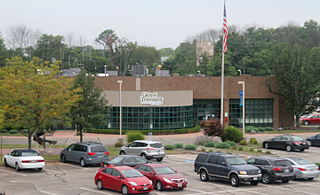
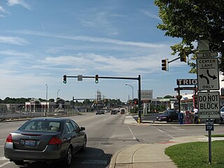
Dent is a census-designated place (CDP) in Green Township, Hamilton County, Ohio, United States. The population was 12,301 at the 2020 census.

<span class="mw-page-title-main">Dry Run, Ohio</span> Census-designated place in Ohio, United States

Dry Run is a census-designated place (CDP) in Hamilton County, Ohio, United States. The population was 7,672 at the 2020 census.

<span class="mw-page-title-main">Forestville, Ohio</span> Census-designated place in Ohio, United States

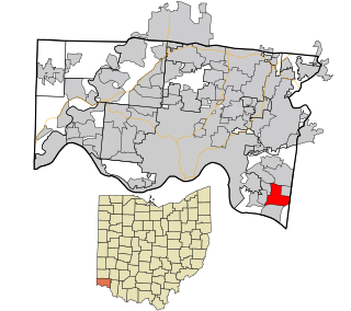
Forestville is a census-designated place (CDP) in Hamilton County, Ohio, United States. The population was 10,615 at the 2020 census.

<span class="mw-page-title-main">Fruit Hill, Ohio</span> Census-designated place in Ohio, United States

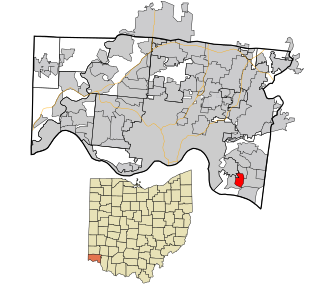
Fruit Hill is a census-designated place (CDP) in Hamilton County, Ohio, United States. The population was 3,748 at the 2020 census.

<span class="mw-page-title-main">Grandview, Hamilton County, Ohio</span> Census-designated place in Ohio, United States

Grandview is a census-designated place (CDP) in Hamilton County, Ohio, United States. The population was 1,312 at the 2020 census.

<span class="mw-page-title-main">Groesbeck, Ohio</span> Census-designated place in Ohio, United States

Groesbeck is a census-designated place (CDP) in Hamilton County, Ohio, United States. The population was 7,365 at the 2020 census. It is a suburb of Cincinnati.

<span class="mw-page-title-main">Kenwood, Ohio</span> Census-designated place in Ohio, United States

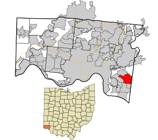
Kenwood is a census-designated place (CDP) in Sycamore Township, Hamilton County, Ohio, United States. The population was 7,570 at the 2020 census. It is a major shopping destination for the Cincinnati area, featuring properties such as Kenwood Towne Centre and The Kenwood Collection.

<span class="mw-page-title-main">Mount Healthy Heights, Ohio</span> Census-designated place in Ohio, United States

Mount Healthy Heights is a census-designated place (CDP) in Hamilton County, Ohio, United States. The population was 2,918 at the 2020 census.

<span class="mw-page-title-main">Northgate, Ohio</span> Census-designated place in Ohio, United States

Northgate is a census-designated place (CDP) in Colerain Township, Hamilton County, Ohio, United States. The population was 7,277 at the 2020 census.

<span class="mw-page-title-main">Pleasant Run Farm, Ohio</span> Census-designated place in Ohio, United States

Pleasant Run Farm is a census-designated place (CDP) in Springfield Township, Hamilton County, Ohio, United States. The population was 4,779 at the 2020 census.

<span class="mw-page-title-main">Sherwood, Hamilton County, Ohio</span> Census-designated place in Ohio, United States

Sherwood is a census-designated place (CDP) in Hamilton County, Ohio, United States. The population was 3,633 at the 2020 census.

<span class="mw-page-title-main">White Oak, Ohio</span> Census-designated place in Ohio, United States

White Oak is a census-designated place (CDP) in Hamilton County, Ohio, United States. It is seven miles northwest of Cincinnati. The population was 19,541 at the 2020 census. White Oak is situated in both Green Township and Colerain Township.

<span class="mw-page-title-main">Loveland Park, Ohio</span> Census-designated place in Ohio, United States

Loveland Park is a census-designated place (CDP) located in Symmes Township, Hamilton County and Deerfield Township, Warren County, in the southwestern part of the U.S. state of Ohio. The CDP is named after the city of Loveland. The population was 1,737 at the 2020 census.

<span class="mw-page-title-main">Dunlap, Ohio</span> Census-designated place in Ohio, United States

Dunlap is a census-designated place (CDP) in Colerain Township, Hamilton County, Ohio, United States. The population was 1,658 at the 2020 census. The siege of Dunlap's Station was a battle that took place near here on the Great Miami in 1791 during the Northwest Indian War.

<span class="mw-page-title-main">Dry Ridge, Ohio</span> Census-designated place in Ohio, United States

Dry Ridge is a census-designated place (CDP) in Colerain Township, Hamilton County, Ohio, United States. The population was 2,698 at the 2020 census.

Pleasant Hills is a census-designated place (CDP) in Hamilton County, Ohio, United States. The population was 950 at the 2020 census.

<span class="mw-page-title-main">Skyline Acres, Ohio</span> Census-designated place in Ohio, United States

Skyline Acres is a census-designated place (CDP) in Colerain and Springfield townships, Hamilton County, Ohio, United States. The population was 1,446 at the 2020 census.

<span class="mw-page-title-main">Taylor Creek, Ohio</span> Census-designated place in Ohio, United States

Taylor Creek is a census-designated place (CDP) in Colerain Township, Hamilton County, Ohio, United States. The population was 4,056 at the 2020 census.

Ridgewood is a census-designated place (CDP) in Hamilton County, Ohio, United States, adjacent to the city of Cincinnati. It was first listed as a CDP prior to the 2020 census. The population was 506 at the 2020 census.

References

  1. "ArcGIS REST Services Directory". United States Census Bureau. Retrieved September 20, 2022.
  2. 1 2 U.S. Geological Survey Geographic Names Information System: Pleasant Run, Ohio
  3. 1 2 "U.S. Census website". United States Census Bureau . Retrieved January 31, 2008.
  4. Scholle, Frank (2010). Colerain Township. Arcadia Publishing. p. 8. ISBN   9780738584331 . Retrieved December 2, 2013.
  5. U.S. Geological Survey Geographic Names Information System: Pleasant Run Post Office
  6. Federal Writers' Project (1940). Ohio: The Ohio Guide. Best Books on. p. 468. ISBN   9781623760342 . Retrieved November 22, 2013.{{cite book}}: |work= ignored (help)
  7. "Census of Population and Housing". Census.gov. Retrieved June 4, 2016.
  8. 1 2 3 4 "Pleasant Run CPD, Ohio - Census Bureau Profile". United States Census Bureau. Retrieved November 26, 2023.