Addyston, Ohio

Last updated

Addyston, Ohio
Building in downtown Addyston.jpg
Main Street in the historic district
Hamilton County Ohio Incorporated and Unincorporated areas Addyston highlighted.svg
Location in Hamilton County and the state of Ohio.
Coordinates: 39°07′50″N84°42′12″W / 39.13056°N 84.70333°W / 39.13056; -84.70333
Country United States
State Ohio
County Hamilton
Township Miami
Government
  MayorLisa Mear [1]
Area
[2]
  Total0.91 sq mi (2.34 km2)
  Land0.85 sq mi (2.20 km2)
  Water0.06 sq mi (0.15 km2)
Elevation
[3]
492 ft (150 m)
Population
 (2020)
  Total927
  Estimate 
(2023) [4]
904
  Density1,093.16/sq mi (422.02/km2)
Time zone UTC-5 (Eastern (EST))
  Summer (DST) UTC-4 (EDT)
ZIP code
45001
Area code 513
FIPS code 39-00436 [5]
GNIS feature ID2397913 [3]
Website www.addystonohio.org

Addyston is a village in Miami Township, Hamilton County, Ohio, United States. Located along the Ohio River, it is a western suburb of the neighboring city of Cincinnati. The population was 927 at the 2020 census. [6]

Contents

History

The village was named after Matthew Addy, the proprietor of a local factory. [7]

Geography

According to the United States Census Bureau, the village has a total area of 0.91 square miles (2.36 km2), of which 0.85 square miles (2.20 km2) is land and 0.06 square miles (0.16 km2) is water. [8]

Demographics

Historical population
CensusPop.Note
1890 1,182
1900 1,51328.0%
1910 1,5432.0%
1920 1,448−6.2%
1930 1,70818.0%
1940 1,610−5.7%
1950 1,6512.5%
1960 1,376−16.7%
1970 1,336−2.9%
1980 1,195−10.6%
1990 1,1980.3%
2000 1,010−15.7%
2010 938−7.1%
2020 927−1.2%
2023 (est.)904 [4] −2.5%
U.S. Decennial Census [9]

2020 census

As of the census of 2020, there were 927 people living in the village, for a population density of 1,093.16 people per square mile (422.02/km2). There were 440 housing units. The racial makeup of the village was 82.4% White, 6.7% Black or African American, 0.9% Native American, 0.2% Asian, 0.0% Pacific Islander, 1.2% from some other race, and 8.6% from two or more races. 2.3% of the population were Hispanic or Latino of any race. [10]

There were 255 households, out of which 52.9% had children under the age of 18 living with them, 46.7% were married couples living together, 14.5% had a male householder with no spouse present, and 22.7% had a female householder with no spouse present. 20.8% of all households were made up of individuals, and 3.9% were someone living alone who was 65 years of age or older. The average household size was 3.10, and the average family size was 3.48. [10]

36.2% of the village's population were under the age of 18, 53.2% were 18 to 64, and 10.6% were 65 years of age or older. The median age was 28.2. For every 100 females, there were 99.0 males. [10]

According to the U.S. Census American Community Survey, for the period 2016-2020 the estimated median annual income for a household in the village was $63,313, and the median income for a family was $61,042. About 27.0% of the population were living below the poverty line, including 44.4% of those under age 18 and 0.0% of those age 65 or over. About 64.6% of the population were employed, and 8.6% had a bachelor's degree or higher. [10]

2010 census

As of the census [11] of 2010, there were 938 people, 372 households, and 228 families living in the village. The population density was 1,103.5 inhabitants per square mile (426.1/km2). There were 448 housing units at an average density of 527.1 per square mile (203.5/km2). The racial makeup of the village was 89.7% White, 5.7% African American, 0.2% Native American, 0.2% Asian, 0.1% from other races, and 4.2% from two or more races. Hispanic or Latino of any race were 1.9% of the population.

There were 372 households, of which 33.6% had children under the age of 18 living with them, 33.6% were married couples living together, 20.7% had a female householder with no husband present, 7.0% had a male householder with no wife present, and 38.7% were non-families. 29.6% of all households were made up of individuals, and 10% had someone living alone who was 65 years of age or older. The average household size was 2.52 and the average family size was 3.15.

The median age in the village was 34.2 years. 25.3% of residents were under the age of 18; 11.5% were between the ages of 18 and 24; 27% were from 25 to 44; 26.1% were from 45 to 64; and 10.2% were 65 years of age or older. The gender makeup of the village was 50.5% male and 49.5% female.

2000 census

As of the census [5] of 2000, there were 1,010 people, 365 households, and 269 families living in the village. The population density was 1,165.1 inhabitants per square mile (449.8/km2). There were 408 housing units at an average density of 470.7 per square mile (181.7/km2). The racial makeup of the village was 87.82% White, 8.42% African American, 0.50% Native American, 0.40% Asian, 1.09% from other races, and 1.78% from two or more races. Hispanic or Latino of any race were 1.78% of the population.

There were 365 households, out of which 40.5% had children under the age of 18 living with them, 44.1% were married couples living together, 24.1% had a female householder with no husband present, and 26.3% were non-families. 24.1% of all households were made up of individuals, and 7.1% had someone living alone who was 65 years of age or older. The average household size was 2.77 and the average family size was 3.22.

In the village, the population was spread out, with 31.7% under the age of 18, 8.8% from 18 to 24, 31.4% from 25 to 44, 18.0% from 45 to 64, and 10.1% who were 65 years of age or older. The median age was 31 years. For every 100 females, there were 98.0 males. For every 100 females age 18 and over, there were 92.2 males.

The median income for a household in the village was $33,000, and the median income for a family was $34,808. Males had a median income of $29,583 versus $25,536 for females. The per capita income for the village was $13,266. About 9.2% of families and 11.6% of the population were below the poverty line, including 14.4% of those under age 18 and 14.8% of those age 65 or over.

See also

Related Research Articles

<span class="mw-page-title-main">Fort Shawnee, Ohio</span> CDP in Ohio, United States

Fort Shawnee is census-designated place (CDP) in Allen County, Ohio, United States. The population was 6,263 at the 2020 census. It is included in the Lima, Ohio Metropolitan Statistical Area. Fort Shawnee is adjacent to the city of Lima and the village of Cridersville in Auglaize County. In 2012, village residents voted to disincorporate the village. According to the United States Census Bureau, the village had a total area of 7.25 square miles (18.78 km2), of which 7.21 square miles (18.67 km2) is land and 0.04 square miles (0.10 km2) is water.

<span class="mw-page-title-main">Polk, Ohio</span> Village in Ohio, United States

Polk is a village in Ashland County, Ohio, United States. The population was 310 at the 2020 census.

<span class="mw-page-title-main">North Kingsville, Ohio</span> Village in Ohio, United States

North Kingsville is a village in Ashtabula County, Ohio, United States. The population was 2,742 at the 2020 census.

<span class="mw-page-title-main">Chatfield, Ohio</span> Village in Ohio, United States

Chatfield is a village in Crawford County, Ohio, United States. The population was 205 at the 2020 census.

<span class="mw-page-title-main">Sugar Grove, Ohio</span> Village in Ohio, United States

Sugar Grove is a village in Fairfield County, Ohio, United States. The population was 429 at the 2020 census.

<span class="mw-page-title-main">Lyons, Ohio</span> Village in Ohio, United States

Lyons is a village in Fulton County, Ohio, United States. The population was 602 at the 2020 census.

<span class="mw-page-title-main">Crown City, Ohio</span> Village in Ohio, United States

Crown City is a village in Gallia County, Ohio, United States, along the Ohio River. The population was 424 at the 2020 census.

<span class="mw-page-title-main">Cleves, Ohio</span> City in Ohio, United States

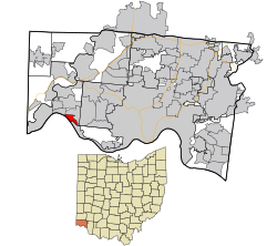
Cleves is a village in Miami Township, Hamilton County, Ohio, United States. Located along the Ohio River, it is a western suburb of Cincinnati. The population was 3,414 at the 2020 census.

<span class="mw-page-title-main">Shawnee, Perry County, Ohio</span> Village in Ohio, United States

Shawnee is a village in Perry County, Ohio, United States. The population was 505 at the 2020 census. It is 9 miles (14 km) south of the county seat of New Lexington.

<span class="mw-page-title-main">Darbyville, Ohio</span> Village in Ohio, United States

Darbyville is a village in Pickaway County, Ohio, United States. The population was 186 at the 2020 census.

<span class="mw-page-title-main">Tarlton, Ohio</span> Village in Ohio, United States

Tarlton is a village in Fairfield and Pickaway counties in the U.S. state of Ohio. The population was 254 at the 2020 census.

<span class="mw-page-title-main">Port Jefferson, Ohio</span> Village in Ohio, United States

Port Jefferson is a village in Salem Township, Shelby County, Ohio, United States. The population was 308 at the 2020 census.

<span class="mw-page-title-main">Limaville, Ohio</span> Census-designated place in Ohio, United States

Limaville is a census-designated place (CDP) and former village in Stark County, Ohio, United States. The population was 151 at the 2020 census. It is part of the Canton–Massillon Metropolitan Statistical Area.

<span class="mw-page-title-main">Wilkesville, Ohio</span> Village in Ohio, United States

Wilkesville is a village in Vinton County, Ohio, United States. The population was 116 at the 2020 census.

<span class="mw-page-title-main">Macksburg, Ohio</span> Village in Ohio, United States

Macksburg is a village in Washington County, Ohio, United States, along the West Fork of Duck Creek. The population was 120 at the 2020 census. The village is about 28 miles (45 km) south of Cambridge, Ohio.

<span class="mw-page-title-main">Harpster, Ohio</span> Village in Ohio, United States

Harpster is a village in Wyandot County, Ohio, United States. The population was 160 at the 2020 census.

<span class="mw-page-title-main">Wilson, Ohio</span> Village in Ohio, United States

Wilson is a village in Belmont and Monroe counties in the U.S. state of Ohio. The population was 129 at the 2020 census. It is part of the Wheeling metropolitan area.

<span class="mw-page-title-main">Clifton, Ohio</span> Village in Ohio, United States

Clifton is a village in Clark and Greene counties in the U.S. state of Ohio and is home to the Clifton Mill, one of the largest water-powered grist mills still in existence. The population was 131 at the 2020 census.

<span class="mw-page-title-main">Verona, Ohio</span> Village in Ohio, United States

Verona is a village in Montgomery and Preble counties in the U.S. state of Ohio. The population was 403 at the 2020 census. It is part of the Dayton Metropolitan Statistical Area.

<span class="mw-page-title-main">Miami Township, Hamilton County, Ohio</span> Township in Ohio, United States

Miami Township is one of the twelve townships of Hamilton County, Ohio, United States. The population was 15,969 as of the 2020 census.

References

  1. "Election Night Reporting". Hamilton County Board of Elections. Retrieved November 9, 2023.
  2. "ArcGIS REST Services Directory". United States Census Bureau. Retrieved September 20, 2022.
  3. 1 2 U.S. Geological Survey Geographic Names Information System: Addyston, Ohio
  4. 1 2 "Annual Estimates of the Resident Population for Incorporated Places in Ohio: April 1, 2020 to July 1, 2023". United States Census Bureau. Retrieved May 16, 2024.
  5. 1 2 "U.S. Census website". United States Census Bureau . Retrieved January 31, 2008.
  6. "Profile of General Population and Housing Characteristics: 2010 Demographic Profile Data (DP-1): Addyston village, Ohio". United States Census Bureau . Retrieved October 31, 2012.
  7. Overman, William Daniel (1958). Ohio Town Names. Akron, OH: Atlantic Press. p. 1.
  8. "US Gazetteer files 2010". United States Census Bureau. Archived from the original on January 25, 2012. Retrieved January 6, 2013.
  9. "Census of Population and Housing". Census.gov. Retrieved June 4, 2015.
  10. 1 2 3 4 "Addyston village, Ohio - Census Bureau Profile". United States Census Bureau. Retrieved October 12, 2023.
  11. "U.S. Census website". United States Census Bureau . Retrieved January 6, 2013.