Woodlawn, Ohio

Last updated

Woodlawn, Ohio
Burchenal Mound from the south.jpg
Burchenal Mound in Glenwood Gardens Park
Hamilton County Ohio Incorporated and Unincorporated areas Woodlawn highlighted.svg
Location in Hamilton County and the state of Ohio
Coordinates: 39°15′06″N84°28′20″W / 39.25167°N 84.47222°W / 39.25167; -84.47222
Country United States
State Ohio
County Hamilton
Government
  MayorBrian K. Poole (D) [1]
Area
[2]
  Total2.56 sq mi (6.62 km2)
  Land2.56 sq mi (6.62 km2)
  Water0.00 sq mi (0.00 km2)
Elevation
[3]
587 ft (179 m)
Population
 (2020)
  Total3,916
  Density1,532.68/sq mi (591.66/km2)
Time zone UTC-5 (Eastern (EST))
  Summer (DST) UTC-4 (EDT)
FIPS code 39-86366
GNIS feature ID1086236 [3]
Website www.beautifulwoodlawn.us

Woodlawn is a village in Hamilton County, Ohio, United States. The population was 3,916 at the 2020 census.

Contents

History

Woodlawn was platted in 1876. [4]

Geography

According to the United States Census Bureau, the village has a total area of 2.57 square miles (6.66 km2), all land. [5]

Demographics

Historical population
CensusPop.Note
1950 1,335
1960 1,007−24.6%
1970 3,251222.8%
1980 2,715−16.5%
1990 2,674−1.5%
2000 2,8165.3%
2010 3,29417.0%
2020 3,91618.9%
U.S. Decennial Census [6]

2020 census

As of the census of 2020, there were 3,916 people living in the village, for a population density of 1,532.68 people per square mile (591.66/km2). There were 1,984 housing units. The racial makeup of the village was 28.0% White, 58.8% Black or African American, 0.3% Native American, 3.4% Asian, 0.0% Pacific Islander, 4.2% from some other race, and 5.2% from two or more races. 6.5% of the population were Hispanic or Latino of any race. [7]

There were 1,731 households, out of which 24.2% had children under the age of 18 living with them, 26.2% were married couples living together, 24.1% had a male householder with no spouse present, and 43.8% had a female householder with no spouse present. 46.7% of all households were made up of individuals, and 15.6% were someone living alone who was 65 years of age or older. The average household size was 2.15, and the average family size was 3.20. [7]

17.1% of the village's population were under the age of 18, 67.3% were 18 to 64, and 15.6% were 65 years of age or older. The median age was 39.4. For every 100 females, there were 71.1 males. [7]

According to the U.S. Census American Community Survey, for the period 2016-2020 the estimated median annual income for a household in the village was $54,345, and the median income for a family was $73,417. About 19.0% of the population were living below the poverty line, including 27.4% of those under age 18 and 11.3% of those age 65 or over. About 65.1% of the population were employed, and 33.9% had a bachelor's degree or higher. [7]

2010 census

As of the census [8] of 2010, there were 3,294 people, 1,507 households, and 766 families living in the village. The population density was 1,281.7 inhabitants per square mile (494.9/km2). There were 1,668 housing units at an average density of 649.0 per square mile (250.6/km2). The racial makeup of the village was 26.1% White, 67.2% African American, 0.2% Native American, 2.9% Asian, 0.1% Pacific Islander, 1.1% from other races, and 2.5% from two or more races. Hispanic or Latino of any race were 2.3% of the population.

There were 1,507 households, of which 24.2% had children under the age of 18 living with them, 26.7% were married couples living together, 18.8% had a female householder with no husband present, 5.2% had a male householder with no wife present, and 49.2% were non-families. 41.9% of all households were made up of individuals, and 7.9% had someone living alone who was 65 years of age or older. The average household size was 2.10 and the average family size was 2.93.

The median age in the village was 39.6 years. 18.9% of residents were under the age of 18; 10.6% were between the ages of 18 and 24; 27.7% were from 25 to 44; 26.9% were from 45 to 64; and 15.8% were 65 years of age or older. The gender makeup of the village was 45.0% male and 55.0% female.

2000 census

As of the census [9] of 2000, there were 2,816 people, 1,235 households, and 687 families living in the village. The population density was 1,089.3 inhabitants per square mile (420.6/km2). There were 1,330 housing units at an average density of 514.5 per square mile (198.6/km2). The racial makeup of the village was 27.10% White, 68.39% African American, 0.11% Native American, 2.38% Asian, 0.89% from other races, and 1.14% from two or more races. Hispanic or Latino of any race were 1.28% of the population.

There were 1,235 households, out of which 21.6% had children under the age of 18 living with them, 33.7% were married couples living together, 17.9% had a female householder with no husband present, and 44.3% were non-families. 37.1% of all households were made up of individuals, and 7.5% had someone living alone who was 65 years of age or older. The average household size was 2.27 and the average family size was 3.06.

In the village, the population was spread out, with 22.3% under the age of 18, 9.9% from 18 to 24, 32.2% from 25 to 44, 23.4% from 45 to 64, and 12.1% who were 65 years of age or older. The median age was 36 years. For every 100 females there were 95.4 males. For every 100 females age 18 and over, there were 91.7 males.

The median income for a household in the village was $42,978, and the median income for a family was $51,893. Males had a median income of $40,417 versus $31,142 for females. The per capita income for the village was $24,204. About 9.1% of families and 10.4% of the population were below the poverty line, including 18.6% of those under age 18 and 8.4% of those age 65 or over.

Related Research Articles

<span class="mw-page-title-main">Woodlawn Heights, Indiana</span> Town in Indiana, United States

Woodlawn Heights is a town in Anderson Township, Madison County, Indiana, United States. It is part of the Indianapolis–Carmel–Anderson metropolitan statistical area. The population was 91 at the 2020 census.

<span class="mw-page-title-main">Woodlawn, Kentucky</span> City in Kentucky, United States

Woodlawn is a home rule-class city in Campbell County, Kentucky, United States. The population was 212 at the 2020 census.

<span class="mw-page-title-main">Beechwood Village, Kentucky</span> City in Kentucky, United States

Beechwood Village is a home rule-class city in Jefferson County, Kentucky, United States. The city was formally incorporated by the state assembly in 1950. The population was 1,280 as of the 2020 census, down from 1,324 at the 2010 census

<span class="mw-page-title-main">Woodlawn Park, Kentucky</span> City in Kentucky, United States

Woodlawn Park is a home rule-class city in Jefferson County, Kentucky, United States. The population was 942 at the 2010 census, down from 1,033 at the 2000 census.

<span class="mw-page-title-main">Woodlawn, Prince George's County, Maryland</span> Census-designated place in Maryland

Woodlawn is an unincorporated area and census-designated place (CDP) in Prince George's County, Maryland, United States. As of the 2020 census it had a population of 7,541.

<span class="mw-page-title-main">Grantwood Village, Missouri</span> Town in Missouri, United States

Grantwood Village is a town in St. Louis County, Missouri, United States. The population was 863 at the 2010 census.

<span class="mw-page-title-main">Sycamore Hills, Missouri</span> Village in Missouri, United States

Sycamore Hills is a village in St. Louis County, Missouri, United States. The population is 560 at the 2020 census.

<span class="mw-page-title-main">Hanley Hills, Missouri</span> Village in Missouri, United States

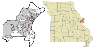
Hanley Hills is a village in St. Louis County, Missouri, United States. The population was 2,101 at the 2010 census.

<span class="mw-page-title-main">Woodlawn, North Carolina</span> Census-designated place in North Carolina, United States

Woodlawn is a census-designated place in Alamance County, North Carolina, United States.

<span class="mw-page-title-main">Addyston, Ohio</span> Village in Ohio, United States

Addyston is a village in Miami Township, Hamilton County, Ohio, United States. Located along the Ohio River, it is a western suburb of the neighboring city of Cincinnati. The population was 927 at the 2020 census.

<span class="mw-page-title-main">Cleves, Ohio</span> City in Ohio, United States

Cleves is a village in Miami Township, Hamilton County, Ohio, United States. Located along the Ohio River, it is a western suburb of Cincinnati. The population was 3,414 at the 2020 census.

<span class="mw-page-title-main">Elmwood Place, Ohio</span> Village in Hamilton County, Ohio, United States

Elmwood Place is a village in Hamilton County, Ohio, United States. The population was 2,087 at the 2020 census. Except for a small portion which touches neighboring St. Bernard, Elmwood Place is nearly surrounded by the city of Cincinnati.

<span class="mw-page-title-main">Evendale, Ohio</span> Village in Ohio, United States

Evendale is a village in Hamilton County, Ohio, United States, within the Cincinnati metropolitan area. The population was 2,669 at the 2020 census.

<span class="mw-page-title-main">Glendale, Ohio</span> Village in Ohio, United States

Glendale is a village in Hamilton County, Ohio, United States. The population was 2,298 at the 2020 census. It is a northern suburb of Cincinnati, and is the site of the Glendale Historic District.

<span class="mw-page-title-main">Tarlton, Ohio</span> Village in Ohio, United States

Tarlton is a village in Fairfield and Pickaway counties in the U.S. state of Ohio. The population was 254 at the 2020 census.

<span class="mw-page-title-main">Roswell, Ohio</span> Village in Ohio, United States

Roswell is a village in Tuscarawas County, Ohio, United States. The population was 219 at the 2020 census.

<span class="mw-page-title-main">Bethlehem, West Virginia</span> Village in West Virginia, United States

Bethlehem is a village in Ohio County, West Virginia, United States. It is part of the Wheeling, West Virginia Metropolitan Statistical Area. The population was 2,499 at the 2010 census.

<span class="mw-page-title-main">Sharonville, Ohio</span> City in Ohio, United States

Sharonville is a city largely in Hamilton County in the U.S. state of Ohio. The population was 14,117 at the 2020 census.

<span class="mw-page-title-main">Verona, Ohio</span> Village in Ohio, United States

Verona is a village in Montgomery and Preble counties in the U.S. state of Ohio. The population was 403 at the 2020 census. It is part of the Dayton Metropolitan Statistical Area.

<span class="mw-page-title-main">Dallas, Wisconsin</span> Village in Wisconsin, United States

Dallas is a village in Barron County in the U.S. state of Wisconsin. The population was 409 at the 2010 census. The village is located within the Town of Dallas.

References

  1. "Hamilton County Officials 2016" (PDF). Hamilton County Board of Elections. January 27, 2016. p. 44. Retrieved February 1, 2016.
  2. "ArcGIS REST Services Directory". United States Census Bureau. Retrieved September 20, 2022.
  3. 1 2 U.S. Geological Survey Geographic Names Information System: Woodlawn, Ohio
  4. Nelson, S. B. (1894). "History of Cincinnati and Hamilton County, Ohio: Their Past and Present, Including...biographies and Portraits of Pioneers and Representative Citizens, etc., Volume 1". p. 441. Retrieved December 11, 2013.
  5. "US Gazetteer files 2010". United States Census Bureau . Retrieved January 6, 2013.
  6. "Census of Population and Housing". Census.gov. Retrieved June 4, 2015.
  7. 1 2 3 4 "Woodlawn village, Ohio - Census Bureau Profile". United States Census Bureau. Retrieved October 23, 2023.
  8. "U.S. Census website". United States Census Bureau . Retrieved January 6, 2013.
  9. "U.S. Census website". United States Census Bureau . Retrieved January 31, 2008.