Laurium is a village in Calumet Township, Houghton County in the U.S. state of Michigan, in the center of the Keweenaw Peninsula. The population was 1,977 at the 2010 census.

Roaring Spring is a borough in Blair County, Pennsylvania, United States. The population was 2,585 at the 2010 census. It is part of the Altoona, PA Metropolitan Statistical Area

Wickliffe Mounds is a prehistoric, Mississippian culture archaeological site located in Ballard County, Kentucky, just outside the town of Wickliffe, about 3 miles (4.8 km) from the confluence of the Ohio and Mississippi rivers. Archaeological investigations have linked the site with others along the Ohio River in Illinois and Kentucky as part of the Angel Phase of Mississippian culture. Wickliffe Mounds is controlled by the State Parks Service, which operates a museum at the site for interpretation of the ancient community. Listed on the National Register of Historic Places, it is also a Kentucky Archeological Landmark and State Historic Site.

Italian Village is a neighborhood in Columbus, Ohio, that contains an array of residential, commercial, and industrial buildings. It is a designated historic district, known for its historical and cultural preservation. The building types and architecture reflect Italian influence. With its parks and preserved historic homes, Italian Village has the highest home value appreciation in Columbus.

The Old Jeffersonville Historic District is located in Jeffersonville, Indiana, United States. It marks the original boundaries of Jeffersonville, and is the heart of modern-day downtown Jeffersonville. It was placed on the National Register of Historic Places in 1983. The area is roughly bounded by Court Avenue at the North, Graham Street on the east, the Ohio River at the south, and Interstate 65 at the west. In total, the district has 203 acres (0.8 km2), 500 buildings, 6 structures, and 11 objects. Several banks are located in the historic buildings in the district. The now defunct Steamboat Days Festival, held on the second weekend in September, used to be held on Spring Street and the waterfront. Jeffersonville's largest fire wiped out a block in the historic district on January 11, 2004 which destroyed the original Horner's Novelty store.
Columbus, the state capital and Ohio's largest city, has numerous neighborhoods within its city limits. Neighborhood names and boundaries are not officially defined. They may vary or change from time to time due to demographic and economic variables.

The Mariemont Historic District is a National Historic Landmark District encompassing most of the municipality of Mariemont, Ohio, USA. Mariemont was planned and developed in the 1920s by philanthropist Mary Emery and landscape architect John Nolen, and was one of the nation's first planned suburban communities. Its architecture and streetscape are still strongly evocative of its original plans. A large portion of the community was listed on the National Register of Historic Places in 1979; a larger area was designated a National Historic Landmark in 2007.

The Rhinebeck Village Historic District is located along US 9 and NY 308 in Rhinebeck, New York, United States. It is an area of 167 acres (68 ha) contains 272 buildings in a variety of architectural styles dating from over 200 years of the settlement's history. It was recognized as a historic district and added to the National Register of Historic Places in 1979 as a cohesive area of preserved historic buildings.

The Scales Mound Historic District is a historic district in the small Illinois village of Scales Mound. The district encompasses the entire corporate limit of the village and has more than 200 properties within its boundaries. The district was added to the U.S. National Register of Historic Places in 1990.

The Central Avenue Historic District is a small segment of the larger Grafton Hill neighborhood of Dayton, Ohio, United States. Composed of just two blocks near the border between Grafton Hill and Dayton View, the historic district comprises a cohesive collection of houses dating primarily from the turn of the 20th century, and it has been named a historic site.

The Noank Historic District is a historic district encompassing the historic main part of the village of Noank in the town of Groton, Connecticut. The district contains a distinctive assortment of mid-to-late 19th-century residential architecture that is notable for its often picturesque woodwork. At the time of their construction, the village was primarily a worker village for nearby shipyards. The district was listed on the National Register of Historic Places in 1979.

The Clinton Village Historic District encompasses the historic portion of the town center of Clinton, Connecticut. It is roughly linear and extends along East Main Street from the Indian River in the west to Old Post Road in the east. The area represents a well-preserved mid-19th century town center, with architecture dating from the late 17th to mid-20th centuries. The district was listed on the National Register of Historic Places in 1994.

The Mill Village Historic District is a historic district encompassing a well-preserved 19th century mill village in Williamstown, Massachusetts. It is located on Cole Avenue and other streets east of Cole and south of the Hoosac River, which provided the mill's power. The complex dates to the mid-19th century, and includes tenement houses, housing for supervisors and specialty personnel, as well as a surviving mill building. The village district was listed on the National Register of Historic Places in 1983.
The South Amherst Common Historic District encompasses the village common and surrounding buildings of South Amherst, Massachusetts. This area developed as a rural residential village hub in the 18th and 19th centuries. It was listed on the National Register of Historic Places in 1995.

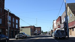
The Calumet Historic District is a National Historic Landmark District that encompasses most of the village of Calumet, Michigan. The district was designated in 1989 for the community's importance in the history of the region's copper mining industry.

The Lake Linden Historic District is located in the village of Lake Linden in Houghton County, Michigan.

The Greenwich Avenue Historic District is a historic district representing the commercial and civic historical development of the downtown area of the town of Greenwich, Connecticut. The district was listed on the National Register of Historic Places on August 31, 1989. Included in the district is the Greenwich Municipal Center Historic District, which was listed on the National Register the year before for the classical revival style municipal buildings in the core of Downtown. Most of the commercial buildings in the district fall into three broad styles, reflecting the period in which they were built: Italianate, Georgian Revival, and Commercial style. The district is linear and runs north–south along the entire length of Greenwich Avenue, the main thoroughfare of Downtown Greenwich, between U.S. Route 1 and the New Haven Line railroad tracks.

East Wheeling Historic District is a national historic district located at Wheeling, Ohio County, West Virginia. The district encompasses 300 contributing buildings and one contributing site, including the Monroe Street East Historic District. The district is primarily residential, developed in the late-19th and early-20th century. A number of popular architectural styles are represented including Greek Revival and Gothic Revival. Notable non-residential buildings include St. Joseph Cathedral (1926), former Hazel Atlas Company building, Scottish Rite Temple designed by noted Wheeling architect Frederick F. Faris (1870-1927), Elks Building, and YMCA (1906), also designed by Faris. The contributing site is Elk Playground. Also located in the district are the separately listed L. S. Good House, Charles W. Russell House, and Cathedral Parish School.

The Willow–Bluff–3rd Street Historic District is a nationally recognized historic district located in Council Bluffs, Iowa, United States. It was listed on the National Register of Historic Places in 2005. At the time of its nomination the district consisted of 260 resources, including 162 contributing buildings, 56 contributing structures, 36 non-contributing buildings, and six non-contributing structures. The district is primarily a residential area that is adjacent to the central business district to the west. Part of the district is in Jackson's Addition, which is the first addition to the original town of Council Bluffs. It also sits along the base of the loess bluffs to the east.

The Watertown Center Historic District encompasses the historic village center of Watertown, Connecticut. It exhibits architectural and historic changes from the early 1700s into the 20th century. It is roughly bounded by Main, Warren, North, Woodbury, Woodruff, and Academy Hill Roads, and was listed on the National Register of Historic Places in 2001.


