
This is a list of properties and districts in Indiana that are listed on the National Register of Historic Places. There are over 1,900 in total. Of these, 39 are National Historic Landmarks. Each of Indiana's 92 counties has at least two listings.

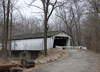
The Big Rocky Fork Covered Bridge is located 1 mile (1.6 km) southeast of Mansfield, Indiana, on County Road 720 and about 2 miles (3.2 km) east of State Road 59, in Parke County.

The Beeson Covered Bridge originally crossed Roaring Creek, one mile (1.6 km) northwest of Marshall, Indiana, on County Road 216, in Washington Township, Parke County. The bridge was moved to its current location in Billie Creek Village in December 1979.

The McAllister Covered Bridge is a Burr Arch structure that was built by Joseph A. Britton and Son in 1914. It is 144 feet (44 m) long, 16 feet (4.9 m) wide, and 14 feet (4.3 m) high. It is found in Adams Township, Parke County, Indiana, United States.

The Marshall Covered Bridge is a single span Burr arch truss covered bridge structure that was built by Joseph A. Britton & Son in 1917. The bridge is 74 ft (23 m) long, 15 ft (4.6 m) wide, and 14 ft (4.3 m) high.

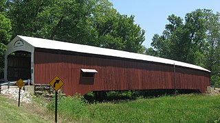
The Mecca Covered Bridge crossing Big Raccoon Creek East of Mecca, Indiana is a single span Burr Arch Truss covered bridge structure that was built by J. J. Daniels in 1873. The bridge is 176 feet (54 m) long, 17 feet (5.2 m) wide, and 12.5 feet (3.8 m) high.

The Sim Smith Covered Bridge is east of Montezuma, Indiana. The single span Burr Truss covered bridge structure was built by Joseph A. Britton in 1883. The bridge is 101 feet (31 m) long, 16 feet (4.9 m) wide, and 14 feet (4.3 m) high.

The Wilkins Mill Covered Bridge is north of Rockville, Indiana. The single span Burr Arch Truss covered bridge structure was built by William Hendricks in 1906. The bridge is 120 feet (37 m) long, 16 feet (4.9 m) wide, and 13 feet (4.0 m) high.

The Cumberland Covered Bridge, also known as the Matthews Covered Bridge, is a historic covered bridge spanning the Mississinewa River at Jefferson Township and Matthews, Grant County, Indiana. It was originally called the New Cumberland Covered Bridge, it was built in 1877 by William Parks of Marion, Indiana. This Howe Truss bridge is 181 feet (55 m) long. It is the only remaining covered bridge in Grant County.

The Williams Bridge is a wooden covered bridge built in 1884 and is located in southern Indiana.

Westport Covered Bridge is a historic covered bridge located in Sand Creek Township, Decatur County, Indiana. It was built in 1880, and is a single span, Burr arch bridge on limestone abutments. It measures 130 feet long, 16 feet wide and 13 feet high. It is topped by a gable roof and sided with shiplap siding. It has been limited to pedestrian traffic since 1973.

Spencerville Covered Bridge is a historic covered bridge located at Spencerville, Spencer Township, DeKalb County, Indiana. It was built in 1873, and spans the St. Joseph River. It is a Smith Type 4 truss bridge on concrete piers. It measures 146 feet long and topped by a gable roof and sided with board-and-batten siding. It one of only six remaining Smith trusses in Indiana.

Longwood Covered Bridge is a historic Burr Arch Truss covered bridge located at Connersville, Fayette County, Indiana. The bridge was built in 1884, and measures 97 feet long and 14 feet, 6 inches wide. It is topped by a gable roof and sheathed in wood shingles, wood board siding, and board and batten siding at the gable ends. It was moved in 1984 to Roberts Park in Connersville and situated over dry land.

Snow Hill Covered Bridge, also known as Johnson Fork Covered Bridge, is a historic Howe Truss covered bridge located in Whitewater Township, Franklin County, Indiana. The bridge was built in 1895, and measures 75 feet long. It has a gable roof, is clad in board and natten siding, and has an open clerestory.

Duck Creek Aqueduct, also known as the Metamora Aqueduct and Whitewater Canal Aqueduct, is a historic aqueduct carrying the Whitewater Canal over Duck Creek in Metamora Township, Franklin County, Indiana. Built in 1846, it is the only surviving covered wood aqueduct in the United States. The aqueduct was listed on the National Register of Historic Places and designated a National Historic Landmark in 2014. It is located in the Whitewater Canal Historic District and part of the Metamora Historic District.

Richland-Plummer Creek Covered Bridge, also known as County Bridge #86, is a historic covered bridge located in Taylor Township, Greene County, Indiana. It was built in 1883, and is a Burr Arch Truss structure measuring 102 feet long, 14 feet wide, and 16 feet tall. The single span bridge has walls clad in board and batten siding with Italianate style design elements.
Darlington Covered Bridge is a historic covered bridge located in Franklin Township, Montgomery County, Indiana. It was built in 1868, and is a single span, Howe truss covered bridge that spans Sugar Creek. It measures 166 feet long and has an overall width of 22 feet.

Eugene Covered Bridge, also known as County Bridge No. 75, is a historic Burr Arch Truss covered bridge located in Eugene Township, Vermillion County, Indiana. It was built in 1873, and is a single span covered timber bridge. It measures 180 feet long and 16 feet wide. The bridge spans the Big Vermilion River.
Newport Covered Bridge, also known as the Morehead Covered Bridge and County Bridge No. 67, is a historic Burr Arch Truss covered bridge located in Vermillion Township, Vermillion County, Indiana. It was built in 1885, and is a single span covered timber bridge. It measures 210 feet long and 16 feet wide. The bridge spans the Little Vermilion River.

Marion County Bridge 0501F, also known as Indiana State Bridge 534-C-3439 on SR 100, is a historic truss bridge located on the Michigan Road at Indianapolis, Marion County, Indiana. It was built in 1941–1942, as a bridge along the State Road 100 project. It consists of two identical Warren pony truss sections at each end with two Parker through truss spans at the center. The pony truss sections are each 96 feet long and the through truss spans are 174 feet long.


