Wilkes-Barre Township, Pennsylvania

Last updated

Wilkes-Barre Township
Mohegan Sun Arena at Casey Plaza 2 2012-05-05.JPG
Mohegan Sun Arena at Casey Plaza in Wilkes-Barre Township, home of the Wilkes-Barre/Scranton Penguins of the AHL
Map of Luzerne County, Pennsylvania Highlighting Wilkes-Barre Township.PNG
Location of Wilkes-Barre Township in Luzerne County, Pennsylvania
USA Pennsylvania location map.svg
Red pog.svg
Wilkes-Barre Township
Location of Wilkes-Barre Township in Luzerne County, Pennsylvania
Usa edcp location map.svg
Red pog.svg
Wilkes-Barre Township
Wilkes-Barre Township (the United States)
Coordinates: 41°13′41″N75°52′6″W / 41.22806°N 75.86833°W / 41.22806; -75.86833
CountryUnited States
State Pennsylvania
County Luzerne
Government
  TypeMayor and Council – Home Rule
  MayorCarl Kuren
Area
[1]
  Total2.86 sq mi (7.42 km2)
  Land2.86 sq mi (7.42 km2)
  Water0.00 sq mi (0.00 km2)
Population
 (2020) [2]
  Total3,219 Increase2.svg
  Estimate 
(2021) [2]
3,214
  Density1,013.62/sq mi (391.36/km2)
Time zone UTC-5 (Eastern (EST))
  Summer (DST) UTC-4 (EDT)
FIPS code 42-079-85160
Website twp.wilkesbarre.pa.us

Wilkes-Barre Township is a township with home rule status in Luzerne County, Pennsylvania, United States. It is adjacent to the city of Wilkes-Barre. The population of the township was 3,219 at the 2020 census. [2]

Contents

History

Founding

A plaque marking the approximate location of Teedyuscung's death in 1763 Teedyuscung Mohegan leader plaque in Wilkes-Barre Pennsylvania.jpg
A plaque marking the approximate location of Teedyuscung’s death in 1763
Wyoming Valley in 1778: Fort Durkee (A); Wilkes-Barre Township is visible on the right WyomingValleyForts.jpg
Wyoming Valley in 1778: Fort Durkee (A); Wilkes-Barre Township is visible on the right

In 1753, the Susquehanna Company was formed in Connecticut for settling the Wyoming Valley in present-day Pennsylvania. Connecticut succeeded in purchasing the land from the Native Americans; however, Pennsylvania already claimed the valley through a purchase they made in 1736. In 1762, roughly two hundred Connecticut settlers (Yankees) established a settlement near Mill Creek. They planted wheat and constructed log cabins. They returned to New England for the winter. [4]

Massacre of 1763

The Connecticut settlers returned in the spring of 1763 with their families. A party of Iroquois also visited the area with the dual purpose of inciting the Lenape and killing Teedyuscung, a local Delaware chief. On April 19, 1763, the residence of the chief and twenty others around it were set ablaze. Teedyuscung, under the influence of liquor, perished in the inferno. This was revenge for the death of an Iroquois warrior in 1758. The Iroquois allowed for the Delaware to believe that this atrocity was committed by the settlers. As a result, the Delaware attacked the colonists on October 15, 1763. Thirty settlers were killed, and several others were taken prisoner. Those who managed to escape fled back to New England. The Delaware then burned what was left of the Yankee settlement. [4]

Pennamite–Yankee Wars

In 1769, during the colonial era, the Connecticut settlers (Yankees) returned to Wyoming Valley. Five townships were established by Connecticut Colony. Each one was five square miles and divided amongst forty settlers. Wilkes-Barre Township, named in honor of John Wilkes and Isaac Barré, was one of the original townships. Pennsylvanians (Pennamites) also arrived in the valley that same year. [4]

The Connecticut settlers established Fort Durkee, which was named in honor of their leader (Colonel Durkee). This was immediately followed by a series of skirmishes between the Pennsylvanians and Connecticut settlers. The land changed hands several times between the two groups. Finally, after many years of fighting, the land was granted to Pennsylvania. [4]

Coal mining

James Sutton built the first gristmill in the township in 1782. [5] In 1806, a large portion of the territory broke away from the township to form the borough of Wilkes-Barre. Today, the township of Wilkes-Barre occupies a 1-by-3-mile (1.6 by 4.8 km) strip of land adjacent to the southeast border of what is now the city of Wilkes-Barre.

Coal mining was a prominent industry in and around Wilkes-Barre Township in the late 19th and early 20th century. The Laurel Run mine fire started near the village of Georgetown in 1915. The fire under Georgetown was controlled by blocking off the tunnels in the vicinity, robbing it of the necessary oxygen to continue burning. [6]

Expanding commerce

Ice hockey inside the Mohegan Sun Arena at Casey Plaza Manitobamoosegame.jpg
Ice hockey inside the Mohegan Sun Arena at Casey Plaza

The township become a commercial destination in northeastern Pennsylvania, adding the Mohegan Sun Arena at Casey Plaza and several major shopping hubs, including the Arena Hub Plaza, Wilkes-Barre Township Commons, Wilkes-Barre Township Marketplace, and Wyoming Valley Mall. Most of these shopping areas were developed in the early 2000s, although the Wyoming Valley Mall was constructed in the 1970s following the aftermath of Hurricane Agnes.

Tornadoes

The township underwent several devastating tornadoes in the early 20th century (in 1914 and 1917). On Wednesday, June 13, 2018 (at about 10 pm), an EF2 tornado struck the business district of Wilkes-Barre Township. [7] Dozens of commercial buildings were severely damaged. [8] The National Weather Service stated "the tornado touched down near the La-Z-Boy furniture store at Mundy Street and Highland Park Boulevard and continued for three-quarters of a mile ending near I-81 behind Dick's Sporting Goods in the Arena Hub Plaza. It's estimated that the tornado was on the ground for about five minutes." Six people sustained minor injuries. [9]

Geography

Wilkes-Barre Township is located at 41°13′40″N75°52′5″W / 41.22778°N 75.86806°W / 41.22778; -75.86806 (41.227931, −75.868282). [10]

According to the U.S. Census Bureau, the township has a total area of 2.9 square miles (7.4 km2), all land. It is crossed from northeast to southwest by I-81/PA 309 and PA 309 Business (Wilkes-Barre Township Boulevard). I-81 has two interchanges in the township: one at the southwest end with PA 309 and one in the central portion near the Mohegan Sun Arena at Casey Plaza. Other important roads are Kidder Street, Mundy Street, Highland Park Boulevard, Coal Street, Northampton Street, and Blackman Street. Its only village is Georgetown on Northampton Street.

Climate

The township has a humid continental climate (Dfa/Dfb) and the hardiness zone is 6a. Average monthly temperatures in the vicinity of exit 168 of I-81 (connecting with Highland Park Boulevard) range from 25.6 °F (−3.6 °C) in January to 71.5 °F (21.9 °C) in July. [11]

Demographics

Historical population
CensusPop.Note
2000 3,235
2010 2,967−8.3%
2020 3,2198.5%
2021 (est.)3,214 [2] −0.2%
U.S. Decennial Census [12]

As of the census [13] of 2000, there were 3,235 people, 1,455 households, and 846 families residing in the township. The population density was 1,093.2 inhabitants per square mile (422.1/km2). There were 1,572 housing units at an average density of 531.2 per square mile (205.1/km2). The racial makeup of the township was 92.92% White, 2.35% African American, 0.22% Native American, 3.62% Asian, 0.09% from other races, and 0.80% from two or more races. 0.77% of the population were Hispanic or Latino of any race.

There were 1,455 households, out of which 22.3% had children under the age of 18 living with them, 42.4% were married couples living together, 11.4% had a female householder with no husband present, and 41.8% were non-families. 37.2% of all households were made up of individuals, and 17.1% had someone living alone who was 65 years of age or older. The average household size was 2.16 and the average family size was 2.86.

In the township, the population was spread out, with 17.9% under the age of 18, 6.4% from 18 to 24, 30.8% from 25 to 44, 22.1% from 45 to 64, and 22.8% who were 65 years of age or older. The median age was 42 years. For every 100 females there were 92.4 males. For every 100 females age 18 and over, there were 87.6 males.

The median income for a household in the township was $30,603, and the median income for a family was $37,188. Males had a median income of $30,806 versus $27,426 for females. The per capita income for the township was $20,055. About 7.2% of families and 9.5% of the population were below the poverty line, including 6.2% of those under age 18 and 13.1% of those age 65 or over.

Related Research Articles

<span class="mw-page-title-main">Wilkes-Barre, Pennsylvania</span> City in Pennsylvania, United States

Wilkes-Barre is a city in and the county seat of Luzerne County, Pennsylvania, United States. Located at the center of the Wyoming Valley in Northeastern Pennsylvania, it had a population of 44,328 in the 2020 census. It is the second-largest city, after Scranton, in the Scranton–Wilkes-Barre–Hazleton, PA Metropolitan Statistical Area, which had a population of 567,559 as of the 2020 census, making it the fifth-largest metropolitan area in Pennsylvania after the Delaware Valley, Greater Pittsburgh, the Lehigh Valley, and Greater Harrisburg.

<span class="mw-page-title-main">Luzerne County, Pennsylvania</span> County in Pennsylvania, United States

Luzerne County is a county in the Commonwealth of Pennsylvania. According to the United States Census Bureau, the county has a total area of 906 square miles (2,350 km2), of which 890 square miles (2,300 km2) is land and 16 square miles (41 km2) is water. It is Northeastern Pennsylvania's second-largest county by total area. As of the 2020 census, the population was 325,594, making it the most populous county in the northeastern part of the state. The county seat and largest city is Wilkes-Barre. Other populous communities include Hazleton, Kingston, Nanticoke, and Pittston. Luzerne County is included in the Scranton–Wilkes-Barre–Hazleton Metropolitan Statistical Area, which has a total population of 555,426 as of 2017.

<span class="mw-page-title-main">Back Mountain</span> Region in Pennsylvania, United States

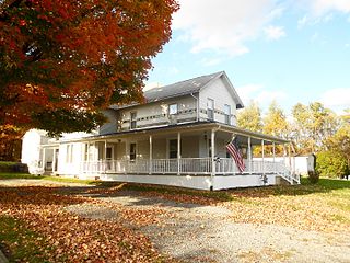
The Back Mountain is a region and former census-designated place (CDP) in Luzerne County, Pennsylvania, United States. It is near the cities of Scranton and Wilkes-Barre. The population was 33,551 as of 2016. The region has a total area of 117.59 square miles (304.6 km2). The area was not delineated as a CDP for the 2010 census. The name "Back Mountain" refers to the area's location behind the mountain ridge forming the northwest side of the Wyoming Valley. The area includes the townships of Dallas, Franklin, Jackson, Kingston, Lake, and Lehman. The region also includes the boroughs of Dallas and Harveys Lake. Each township and borough is independently governed.

<span class="mw-page-title-main">Exeter, Pennsylvania</span> Borough in Pennsylvania, United States

Exeter is a borough in the Greater Pittston-Wilkes-Barre area of Luzerne County, Pennsylvania, United States, about 10 miles (16 km) west of Scranton and a few miles north of Wilkes-Barre. It is located on the western bank of the Susquehanna River and has a total area of 5.0 square miles (12.9 km2). As of 2020, Exeter had a population of 5,513.

<span class="mw-page-title-main">Exeter Township, Luzerne County, Pennsylvania</span> Township in Pennsylvania, United States

Exeter Township is a township within the Greater Pittston area of Luzerne County, Pennsylvania, United States. The population was 2,047 at the 2020 census. Upper Exeter and Harding are two villages in the township.

<span class="mw-page-title-main">Fairmount Township, Luzerne County, Pennsylvania</span> Township in Pennsylvania, United States

Fairmount Township is a township in Luzerne County, Pennsylvania, United States. The population was 1,207 at the 2020 census. Fairmount Township is home to Ricketts Glen State Park. The park receives tens of thousands of visitors each year.

<span class="mw-page-title-main">Fairview Township, Luzerne County, Pennsylvania</span> Township in Pennsylvania, United States

Fairview Township is a township in Luzerne County, Pennsylvania, United States. The population was 4,691 at the 2020 census.

<span class="mw-page-title-main">Forty Fort, Pennsylvania</span> Borough in Pennsylvania, United States

Forty Fort is a borough in Luzerne County, Pennsylvania, United States. The population was 4,233 at the 2020 census. Its neighbors are Wyoming, Plains Township, Kingston, and Swoyersville. The Wilkes-Barre Wyoming Valley Airport and the Wyoming Seminary Lower School are both located in the borough.

<span class="mw-page-title-main">Hanover Township, Luzerne County, Pennsylvania</span> Township in Pennsylvania, United States

Hanover Township is a township in Luzerne County, Pennsylvania. As of the 2020 census, the population was 11,424, making it the most populous township in the county.

<span class="mw-page-title-main">Kingston, Pennsylvania</span> Borough in Pennsylvania, United States

Kingston is a borough in Luzerne County, Pennsylvania, United States. It is located on the western bank of the Susquehanna River opposite Wilkes-Barre. Kingston was first settled in the early 1770s, and incorporated as a borough in 1857. As of the 2020 census, the population was 13,349, making it the most populous borough in Luzerne County.

<span class="mw-page-title-main">Nanticoke, Pennsylvania</span> City in Pennsylvania, United States

Nanticoke is a city in Luzerne County, Pennsylvania, United States. As of the 2020 census, the population was 10,628, making it the third largest city in Luzerne County. It occupies 3.5 square miles of land. Nanticoke is part of Northeastern Pennsylvania.

<span class="mw-page-title-main">Pittston Township, Pennsylvania</span> Township in Pennsylvania, United States

Pittston Township is a township in Luzerne County, Pennsylvania. The population was 3,179 as of the 2020 census. The township is located within the Greater Pittston region. As of 2010, the total population of Greater Pittston was 48,020. The Wilkes-Barre/Scranton International Airport is located in Pittston Township.

<span class="mw-page-title-main">Plains Township, Pennsylvania</span> Township in Pennsylvania, United States

Plains Township is a township in Luzerne County, Pennsylvania, United States. The population was 9,816 at the 2020 census. The municipality is the birthplace of Chicago White Sox hall of famer Ed Walsh and John J. Yeosock, a United States Army general who commanded the 3rd U.S. Army during Operation Desert Shield and Operation Desert Storm. Mohegan Pennsylvania is a casino in Plains Township.

<span class="mw-page-title-main">Plymouth Township, Luzerne County, Pennsylvania</span> Township in Pennsylvania, United States

Plymouth Township is located in Luzerne County, Pennsylvania, United States. The population was 1,712 at the 2020 census.

<span class="mw-page-title-main">West Wyoming, Pennsylvania</span> Borough in Pennsylvania, United States

West Wyoming is a borough that is located in Luzerne County, Pennsylvania, United States. The borough is part of the Greater Pittston metro area.

<span class="mw-page-title-main">White Haven, Pennsylvania</span> Borough in Pennsylvania, United States

White Haven is a borough in Luzerne County, Pennsylvania, United States. It is located along the Lehigh River. The population was 1,163 at the 2020 census.

<span class="mw-page-title-main">Wyoming, Pennsylvania</span> Borough in Luzerne County, Pennsylvania, US

Wyoming is a borough in the Greater Pittston area of Luzerne County, Pennsylvania, United States. It is located 5 miles (8 km) north of Wilkes-Barre, along the Susquehanna River. The population was 3,097 as of the 2020 census.

<span class="mw-page-title-main">Tunkhannock, Pennsylvania</span> Borough in Pennsylvania, United States

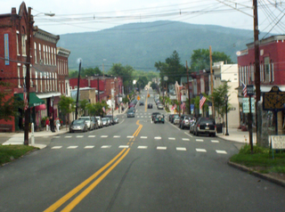
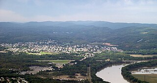
Tunkhannock is a borough in Wyoming County, Pennsylvania, 31 miles (50 km) northwest of Wilkes-Barre. In the past, lumbering was carried on extensively. Today, many residents are employed by the Procter & Gamble plant in nearby Washington Township. As of the 2020 census, the borough population was 1,766. It is the county seat of Wyoming County. Tunkhannock is in the Scranton–Wilkes-Barre–Hazleton, PA Metropolitan Statistical Area.

<span class="mw-page-title-main">Wyoming Valley</span> Metropolitan statistical area in Pennsylvania, United States

The Wyoming Valley is a historic industrialized region of Northeastern Pennsylvania. The region is historically notable for its influence in helping fuel the American Industrial Revolution with its many anthracite coal-mines. As a metropolitan area, it is known as the Scranton/Wilkes-Barre metropolitan area, after its principal cities, Scranton and Wilkes-Barre. With a population of 567,559 as of the 2020 United States census, it is the fifth-largest metropolitan area in Pennsylvania, after the Delaware Valley, Greater Pittsburgh, the Lehigh Valley, and the Harrisburg–Carlisle metropolitan statistical areas.

<span class="mw-page-title-main">Teedyuscung</span> Native American chief

Teedyuscung was known as "King of the Delawares". He worked to establish a permanent Lenape (Delaware) home in eastern Pennsylvania in the Lehigh, Susquehanna, and Delaware River valleys. Teedyuscung participated in the Treaty of Easton, which resulted in the surrender of Lenape claims to all lands in Pennsylvania. Following the treaty, the Lenape were forced to live under the control of the Iroquois in the Wyoming Valley near modern-day Wilkes-Barre. Teedyuscung was murdered by arsonists in the night of April 19, 1763. This marked the beginning of the end of the Lenape presence in Pennsylvania. Teedyuscung's son Chief Bull conducted a raid on the Wyoming Valley that was part of a greater Indian uprising. As a result, the Lenape were forced to move west of the Appalachian Mountains by the Royal Proclamation of 1763.

References

  1. "2016 U.S. Gazetteer Files". United States Census Bureau. Retrieved August 14, 2017.
  2. 1 2 3 4 Bureau, US Census. "City and Town Population Totals: 2020—2021". Census.gov. US Census Bureau. Retrieved July 24, 2022.
  3. Lossing, Benson (1859). The Pictorial Field-Book of the Revolution. Harper & Brothers, Publishers. p. 353.
  4. 1 2 3 4 "Early Wilkes-Barre, Luzerne Co., Pa".
  5. "Wilkes-Barre Township". Pagenweb.org. Retrieved June 19, 2018.
  6. Glenn B. Stracher, ed. (January 1, 2007), Geology of Coal Fires: Case Studies from Around the World, ISBN   9780813741185 , retrieved January 30, 2014
  7. "EF2 tornado hit near Wilkes-Barre, National Weather Service confirms". Mcall.com. June 14, 2018. Retrieved June 19, 2018.
  8. Jayne Ann Bugda (June 15, 2018). "List of Businesses Impacted in Wilkes-Barre Township by Tornado". Pahomepage. Retrieved June 19, 2018.
  9. "EF2 tornado hits Wilkes-Barre Township". timesleader.com. Times Leader. June 14, 2018.
  10. "US Gazetteer files: 2010, 2000, and 1990". United States Census Bureau. February 12, 2011. Retrieved April 23, 2011.
  11. "PRISM Climate Group at Oregon State University".
  12. "Census of Population and Housing". Census.gov. Retrieved June 4, 2016.
  13. "U.S. Census website". United States Census Bureau . Retrieved January 31, 2008.