Related Research Articles

The Gall–Peters projection is a rectangular, equal-area map projection. Like all equal-area projections, it distorts most shapes. It is a cylindrical equal-area projection with latitudes 45° north and south as the regions on the map that have no distortion. The projection is named after James Gall and Arno Peters.

Johannes Kepler was a German astronomer, mathematician, astrologer, natural philosopher and writer on music. He is a key figure in the 17th-century Scientific Revolution, best known for his laws of planetary motion, and his books Astronomia nova, Harmonice Mundi, and Epitome Astronomiae Copernicanae, influencing among others Isaac Newton, providing one of the foundations for his theory of universal gravitation. The variety and impact of his work made Kepler one of the founders and fathers of modern astronomy, the scientific method, natural and modern science. He has been described as the "father of science fiction" for his novel Somnium.

The Mercator projection is a conformal cylindrical map projection presented by Flemish geographer and cartographer Gerardus Mercator in 1569. It became the standard map projection for navigation due to its ability to represent north as 'up' and south as 'down' everywhere while preserving local directions and shapes. However, as a result, the Mercator projection inflates the size of objects the further they are from the equator. In a Mercator projection, landmasses such as Greenland and Antarctica appear far larger than they actually are relative to landmasses near the equator. Despite these drawbacks, the Mercator projection is well-suited to marine navigation and internet web maps and continues to be widely used today.

Gerardus Mercator was a Flemish geographer, cosmographer and cartographer. He is most renowned for creating the 1569 world map based on a new projection which represented sailing courses of constant bearing as straight lines—an innovation that is still employed in nautical charts.

Johann Heinrich Lambert was a polymath from the Republic of Mulhouse, generally identified as either Swiss or French, who made important contributions to the subjects of mathematics, physics, philosophy, astronomy and map projections.
In astronomy and celestial navigation, an ephemeris is a book with tables that gives the trajectory of naturally occurring astronomical objects as well as artificial satellites in the sky, i.e., the position over time. Historically, positions were given as printed tables of values, given at regular intervals of date and time. The calculation of these tables was one of the first applications of mechanical computers. Modern ephemerides are often provided in electronic form. However, printed ephemerides are still produced, as they are useful when computational devices are not available.

Tommaso Campanella, baptized Giovanni Domenico Campanella, was an Italian Dominican friar, philosopher, theologian, astrologer, and poet.
This article lists notable literary events and publications in 1599.

Pedro Nunes was a Portuguese mathematician, cosmographer, and professor, probably from a New Christian family.

A nautical chart or hydrographic chart is a graphic representation of a sea region or water body and adjacent coasts or banks. Depending on the scale of the chart, it may show depths of water (bathymetry) and heights of land (topography), natural features of the seabed, details of the coastline, navigational hazards, locations of natural and human-made aids to navigation, information on tides and currents, local dentists of the Earth's magnetic field, and human-made structures such as harbours, buildings, and bridges. Nautical charts are essential tools for marine navigation; many countries require vessels, especially commercial ships, to carry them. Nautical charting may take the form of charts printed on paper or computerized electronic navigational charts. Recent technologies have made available paper charts which are printed "on demand" with cartographic data that has been downloaded to the commercial printing company as recently as the night before printing. With each daily download, critical data such as Local Notices to Mariners are added to the on-demand chart files so that these charts are up to date at the time of printing.
The year 1645 in science and technology involved some significant events.

Domenico Starnone is an Italian writer, screenwriter, and journalist. He is a prolific book author, having penned at least 22 works since 1987, at least four of which have been translated from Italian into English, including Prima esecuzione and Confidenza. His novel Via Gemito won the Premio Strega in 2001, and movies by Gabriele Salvatores, Riccardo Milani, and Daniele Luchetti have been based on Starnone books.

The history of navigation, or the history of seafaring, is the art of directing vessels upon the open sea through the establishment of its position and course by means of traditional practice, geometry, astronomy, or special instruments. Many peoples have excelled as seafarers, prominent among them the Austronesians, the Harappans, the Phoenicians, the Iranians, the ancient Greeks, the Romans, the Arabs, the ancient Indians, the Norse, the Chinese, the Venetians, the Genoese, the Hanseatic Germans, the Portuguese, the Spanish, the English, the French, the Dutch, and the Danes.
Ferrante Imperato, an apothecary of Naples, published Dell'Historia Naturale and illustrated it with his own cabinet of curiosities displayed at Palazzo Gravina in Naples; the engraving became the first pictorial representation of a Renaissance humanist's displayed natural history research collection. The collection, which the published catalogue made as famous in the seventeenth century as that of that other famous apothecary and virtuoso, Francesco Calceolari of Verona, ranged widely; it embraced a herbarium, shells, birds, sea creatures, in addition to the fossils, clays, minerals and metallic ores, marble and gem species. It was maintained by his son Francesco, who assisted him in writing up his observations, and who may be seen in the engraving pointing out details of the specimens to two visitors as Ferrante looks on.

Emery Molyneux was an English Elizabethan maker of globes, mathematical instruments and ordnance. His terrestrial and celestial globes, first published in 1592, were the first to be made in England and the first to be made by an Englishman.

Edward Wright was an English mathematician and cartographer noted for his book Certaine Errors in Navigation, which for the first time explained the mathematical basis of the Mercator projection by building on the works of Pedro Nunes, and set out a reference table giving the linear scale multiplication factor as a function of latitude, calculated for each minute of arc up to a latitude of 75°. This was in fact a table of values of the integral of the secant function, and was the essential step needed to make practical both the making and the navigational use of Mercator charts.

The Mercator world map of 1569 is titled Nova et Aucta Orbis Terrae Descriptio ad Usum Navigantium Emendate Accommodata. The title shows that Gerardus Mercator aimed to present contemporary knowledge of the geography of the world and at the same time 'correct' the chart to be more useful to sailors. This 'correction', whereby constant bearing sailing courses on the sphere are mapped to straight lines on the plane map, characterizes the Mercator projection. While the map's geography has been superseded by modern knowledge, its projection proved to be one of the most significant advances in the history of cartography, inspiring the 19th century map historian Adolf Nordenskiöld to write "The master of Rupelmonde stands unsurpassed in the history of cartography since the time of Ptolemy." The projection heralded a new era in the evolution of navigation maps and charts and it is still their basis.

The Azores Voyage of 1589, also known as Cumberland's Third Voyage, was a series of conflicts in the Azores islands between August and September 1589 by an English military joint stock expedition led by George Clifford, 3rd Earl of Cumberland, during the Anglo–Spanish War. All the islands were attacked either for provisions or the attainment of Spanish and Portuguese prizes. A number of Portuguese and Spanish ships were captured and also included a battle at Faial which resulted in the capture of the fort and the main town, which was subsequently sacked and burned. The English were able to return home unmolested with a total of thirteen prizes – the expedition was a success and with a good profit for the investors although many people died to disease and storms.
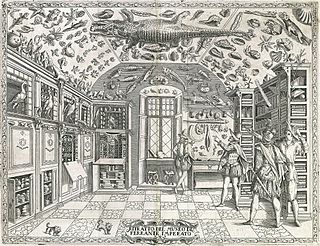
Cabinet of Curiosities in Dell'Historia Naturale depicts Ferrante Imperato's cabinet of curiosities. Imperato was an Italian apothecary and naturalist practicing in Naples during the 16th century. The image shows the types of objects Imperato collected for his cabinet of curiosities, including shells, animals, minerals, and botanic specimens. This print appeared in Historia naturale di Ferrante Imperato napolitano: nella quale ordinatamente si tratta della diversa condition di minere, pietre pretiose, & altre curiosità : con varie historie di piante, & animali, sin'hora non date in luce, otherwise known as Dell’Historia Naturale, a monumental work of natural history in 28 volumes. The exploration of natural history was part of the Renaissance humanist movement and empiricism. The use of senses to formulate new ideas and natural discoveries was at the heart of this movement. The discoveries resulting from empirical exploration were aimed at figuring out how everyone is connected through nature. Imperato's cabinet was part of this movement and provided a place for aristocrats in society to expand their knowledge.
References
- ↑ Grun, Bernard (1991). "1599". The Timetables of History (3rd ed.). New York: Simon & Schuster. p. 267. ISBN 0-671-74919-6.
- ↑ Dell'historia naturale di Ferrante Imperato napolitano Libri XXVIII. Nella quale ordinatamente si tratta della diversa condition di miniere, e pietre. Con alcune historie di piante et animali; sin hora non date in luce.