1990 Bishop's Castle earthquake

Last updated

Bishop's Castle earthquake
England relief location map.jpg
Bullseye1.png
United Kingdom relief location map.jpg
Bullseye1.png
Wales relief location map.jpg
Bullseye1.png
UTC  time1990-04-02 13:46
ISC  event 371099
USGS-ANSS ComCat
Local date2 April 1990 (1990-04-02)
Local time13:46 UTC
Magnitude5.1 ML
Depth14.1 km (8.8 mi)
Epicentre 52°26′N3°02′W / 52.43°N 3.03°W / 52.43; -3.03 Coordinates: 52°26′N3°02′W / 52.43°N 3.03°W / 52.43; -3.03
Areas affected United Kingdom
Max. intensity EMS-98 VI (Slightly damaging)

VI (Strong)
CasualtiesNone

The 1990 Bishop's Castle earthquake occurred near the town of Bishop's Castle, Shropshire, England on 2 April.

Contents

Location, date and time

On 2 April 1990, a powerful earth tremor was felt across much of England and Wales at 13:46 34.2s GMT. Early news reports in the immediate aftermath speculatively attributed the epicentre to places as far apart as Nottingham and a valley in the east of Wales and then settled on Wrexham, [1] before geologists finally concluded that it had in fact been in the vicinity of the small town of Clun near the town of Bishop's Castle, Shropshire. [2]

Cause

Bishops Castle lies atop an ancient geological fault line – the Pontesford-Linley fault. A sudden movement in the fault sent shock waves through the rock. [3] The local rocks are predominantly Jurassic Middle Lias. [4]

Magnitude

The magnitude of the earthquake was originally measured as being between 4.9 and 5.4 on the Richter scale. [1] [5] [6] Its final estimated magnitude was 5.1, [7] which meant that it was the strongest earthquake to have struck the UK since the 1984 Llŷn Peninsula earthquake.

Impact

The earthquake was felt by people as far away as the east of the Republic of Ireland to the west, the city of Newcastle upon Tyne to the north-east, the county of Kent to the south-east, and the county of Cornwall to the south-west.

In Shrewsbury, the county town of Shropshire, which lies approximately 20 miles to the north-east of Bishop's Castle, there was damage to masonry, with a number of chimney stacks being broken off from roofs and collapsing partially or completely into gardens and streets. Some others were knocked askew. Several of the worst affected buildings, including shops, were evacuated. Police cordons were put up around houses at risk of chimney-collapse until they had been made safe, with at least fifty properties in the town reported as requiring emergency attention within the twenty-four hours immediately following the event, while others requiring less urgent treatment were tended to on subsequent days. [8]

There was also damage to ornamental features such as crosses and gargoyles built into the masonry of some of Shrewsbury's medieval churches, and to Clun Castle.

Electrical power was lost from areas served by some substations situated approximately thirty kilometres (seventeen miles) from the epicentre after the earthquake caused transformers at the substations to trip offline. [8]

Residents of the worst affected areas, including parts of Shrewsbury, reported lateral shaking and swaying to the walls of their houses at the height of the tremor, which was preceded and then accompanied by a rumbling noise that gained strength over a period of 15 to 30 seconds before reaching and sustaining peak intensity during the most severe shaking. Finally, the movement and accompanying sound tailed off much more rapidly than it had first built up, stopping altogether within just a few seconds from the peak activity. [9] [10]

Damage to buildings was also reported in Wrexham, and some minor damage as far north as Liverpool and Manchester. [11]

No serious injuries were reported.

An engineering consultant, using the 1990 Bishop's Castle earthquake specifications as a model, has estimated that the slightly weaker 2002 Dudley earthquake measuring 4.8 on the Richter scale would have caused structural damage of an order costing less than 5% of the cost of the complete reconstruction of an entire property to repair, to 1% of buildings situated in towns in the vicinity of the epicentre. [12] While some indication of the typical percentage of homes damaged to a similarly minor extent by a slightly stronger earthquake measuring 5.1 on the Richter scale may be extrapolated from this estimation, a representative of the British Geological Survey has stated that 'numerous' but fewer than 20% of properties in Shrewsbury suffered the partial or total loss of their chimneys or damage of equivalent gravity (see below). Reliable, exact figures of the percentage of buildings damaged close to the epicentre of the 1990 Bishop's Castle earthquake are not readily available, but the aforesaid sources taken together appear clearly to indicate that between 1% and 20% of properties in towns near the epicentre suffered damage of European Macroseismic Scale Grade 7 severity.

The Welsh Borders suffer frequent earthquakes by British standards. Over the last century, there have been sizeable shocks near Hereford in 1896 and 1924, near Shrewsbury in 1932, and near Ludlow in 1926. [13]

See also

Related Research Articles

<span class="mw-page-title-main">Epicenter</span> Point on the Earths surface that is directly above the hypocentre or focus in an earthquake

The epicenter, epicentre or epicentrum in seismology is the point on the Earth's surface directly above a hypocenter or focus, the point where an earthquake or an underground explosion originates.

<span class="mw-page-title-main">Bishop's Castle</span> Town in Shropshire, England

Bishop's Castle is a market town in the south west of Shropshire, England. According to the 2011 Census it had a population of 1,893.

The geology of Shropshire is very diverse with a large number of periods being represented at outcrop. The bedrock consists principally of sedimentary rocks of Palaeozoic and Mesozoic age, surrounding restricted areas of Precambrian metasedimentary and metavolcanic rocks. The county hosts in its Quaternary deposits and landforms, a significant record of recent glaciation. The exploitation of the Coal Measures and other Carboniferous age strata in the Ironbridge area made it one of the birthplaces of the Industrial Revolution. There is also a large amount of mineral wealth in the county, including lead and baryte. Quarrying is still active, with limestone for cement manufacture and concrete aggregate, sandstone, greywacke and dolerite for road aggregate, and sand and gravel for aggregate and drainage filters. Groundwater is an equally important economic resource.

<span class="mw-page-title-main">Pontesford</span> Human settlement in England

Pontesford is a small village in Shropshire, England.

<span class="mw-page-title-main">1993 Scotts Mills earthquake</span> Earthquake in Oregon

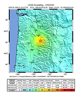
The 1993 Scotts Mills earthquake, also known as the "Spring break quake", occurred in the U.S. state of Oregon on March 25 at 5:34 AM Pacific Standard Time. With a moment magnitude of 5.6 and a maximum perceived intensity of VII on the Mercalli intensity scale, it was the largest earthquake in the Pacific Northwest since the Elk Lake and Goat Rocks earthquakes of 1981. Ground motion was widely felt in Oregon's Willamette Valley, the Portland metropolitan area, and as far north as the Puget Sound area near Seattle, Washington.

<span class="mw-page-title-main">2007 Kent earthquake</span> Earthquake in England

The 2007 Kent earthquake registered 4.3 on the Richter scale and struck south east Kent, South East England on 28 April 2007 at 07:18:12 UTC, at a shallow depth of 5.3 km.

The 1984 Llŷn Peninsula earthquake struck the Llŷn Peninsula in Gwynedd, northwest Wales on Thursday 19 July 1984 at 06:56 UTC. Measuring 5.4 on the Richter scale, it is the largest onshore earthquake to occur in the UK since instrumental measurements began.

<span class="mw-page-title-main">1935 Timiskaming earthquake</span> Earthquake in Canada

The 1935 Temiskamingue earthquake occurred on November 1 with a moment magnitude of 6.1 and a maximum Mercalli intensity of VII. The event took place in the Western Quebec Seismic Zone in the Abitibi-Témiscamingue region of Quebec.

<span class="mw-page-title-main">2008 Market Rasen earthquake</span> 2008 Earthquake epicentred around Market Rasen, Lincolnshire, England

On 27 February 2008 at 00:56:47.8s GMT an earthquake occurred at Market Rasen, Lincolnshire. According to the British Geological Survey the earthquake registered a reading of 5.2 on the Richter scale, with its epicentre 2.5 miles (4 km) north of Market Rasen and 15 miles (24 km) south-west of Grimsby.

<span class="mw-page-title-main">1915 Pleasant Valley earthquake</span>

The 1915 Pleasant Valley earthquake occurred at 22:53:21 on October 2 in north-central Nevada. With a moment magnitude of 6.8, a surface wave magnitude of 7.7, and a maximum Mercalli intensity of X (Extreme), it was the strongest earthquake ever recorded in the state.

<span class="mw-page-title-main">1935 Shinchiku-Taichū earthquake</span> Earthquake in Taiwan

The 1935 Shinchiku-Taichū earthquake occurred with a Richter magnitude of 7.1 (7.0 Mw) in April 1935 with its epicenter in Taichung, Taiwan. It was the deadliest earthquake in Taiwan's recorded history, claiming 3,276 lives and causing extensive damage. Twelve seconds after the mainshock, an aftershock of ML 6.0 occurred, centered on Gabi Village.

<span class="mw-page-title-main">1968 Illinois earthquake</span> Largest recorded earthquake in Illinois, US

The 1968 Illinois earthquake was the largest recorded earthquake in the U.S. Midwestern state of Illinois. Striking at 11:02 am on November 9, it measured 5.4 on the Richter scale. Although no fatalities occurred, the event caused considerable structural damage to buildings, including the toppling of chimneys and shaking in Chicago, the region's largest city. The earthquake was one of the most widely felt in U.S. history, largely affecting 23 states over an area of 580,000 sq mi (1,500,000 km2). In studying its cause, scientists discovered the Cottage Grove Fault in the Southern Illinois Basin.

Linley is a hamlet in Shropshire, England. It is part of the civil parish of More.

<span class="mw-page-title-main">1916 Irondale earthquake</span> Earthquake in Alabama on October 18, 1916

The 1916 Irondale earthquake struck in the north–central region of the U.S. state of Alabama on October 18. The strongest earthquake in state history, it registered an estimated Richter scale magnitude of 5.1 and resulted in extensive, but minor damage. This damage, limited to Shelby and Jefferson counties, reached its maximum severity near the epicenter in the city of Irondale, including cracked windows, fallen chimneys, and dried-up wells. While there were no fatalities, the earthquake spawned widespread panic, sending alarmed workers from tall buildings.

The 1906 Swansea earthquake hit near the town of Swansea, Glamorgan, Wales on 27 June. It was one of the most damaging to hit Britain during the twentieth century, with a small area reaching an intensity of VII on the Medvedev–Sponheuer–Karnik scale.

<span class="mw-page-title-main">1990 Vrancea earthquakes</span> Romanian powerful earthquake

The 1990 Vrancea earthquakes were three earthquakes on 30 and 31 May 1990 with magnitudes of 7.0 Mw and 6.2 Mw  that struck the Romanian county of Vrancea, on two consecutive days. Severe damage in the Bucharest-Brăila-Brașov area was reported and dozens of casualties in Romania and neighbouring Moldova, Ukraine and Bulgaria.

The 1912 Maymyo earthquake or Burma earthquake struck Burma on the morning of May 23, with an epicentre near Taunggyi and Pyin Oo Lwin in Shan State. The earthquake was initially calculated at 8.0 on the surface wave magnitude scale (Ms ) by Beno Gutenberg and Charles Francis Richter, and described by them as being one of the most remarkable seismic events in the early 1900s. Recent re-evaluation of the earthquake, however, have revised the magnitude to 7.6–7.9. It was preceded by two foreshocks on May 18 and 21 with respective intensities V and VII on the Rossi–Forel scale, while the mainshock was assigned IX. Shaking was felt throughout most of Burma, parts of Siam and Yunnan; an area covering approximately 375,000 square miles. It was one of the largest earthquakes in the country.

Two 1914 East Cape earthquakes shook the upper North Island of New Zealand; on Wednesday 7 October and Wednesday 28 October. They were large and shallow, with their epicentres close together northwest of Ruatoria in the Gisborne District. The earthquakes were felt strongly throughout the East Cape area, most noticeably in areas east of the epicentre such as Waipiro Bay, with a large amount of damage occurring in Tokomaru Bay in particular. One person was killed by a landslide near Cape Runaway.

The 1904 Kresna earthquakes occurred on the same day of April 4 in the Ottoman Empire. The pair of earthquakes measured 6.9 and 7.2 on the surface wave magnitude scale, and were assigned the respective Modified Mercalli intensity scale ratings of X (Extreme) and XI (Extreme). More than 200 people were killed in the two earthquakes. Several villages were obliterated as a result.

References

  1. 1 2 "New Scientist". Contemporary account of limitations to the original seismological reporting, which rates the earthquake at 5.4 on the Richter scale. Retrieved 2 February 2008.
  2. "BGS Bishop's Castle page". British Geological Survey web-page on the Bishop's Castle earthquake. Archived from the original on 13 June 2007. Retrieved 2 February 2008.
  3. "Shropshire County Council". Landscape of contrasts. Archived from the original on 20 May 2007. Retrieved 2 February 2008.
  4. "Shropshire Rocks". Archived from the original on 19 November 2008. Retrieved 2 February 2008.
  5. "New Scientist". Another contemporary account from the same issue of New Scientist, 12 April 1990, but rating the magnitude at only 4.9. Retrieved 2 February 2008.
  6. "EERI" (PDF). Contemporary newsletter of the Earthquake Engineering Research Unit, April 1990. Retrieved 3 February 2008.
  7. "BGS Bishop's Castle page". Recent British Geological Survey page on the Bishop's Castle earthquake. Archived from the original on 16 January 2008. Retrieved 3 February 2008.
  8. 1 2 "EERI" (PDF). Contemporary newsletter of the Earthquake Engineering Research Institute, April 1990. Retrieved 3 February 2008.
  9. Google Books. papers presented at the International Conference on Earthquake, Blast and Impact held at the University of Manchester Institute of Science and Technology, UK, 18–20 September 1991, graph. ISBN   978-1-85166-705-5.
  10. Google Books. papers presented at the International Conference on Earthquake, Blast and Impact held at the University of Manchester Institute of Science and Technology, UK, 18–20 September 1991, discussion. ISBN   978-1-85166-705-5.
  11. "USGS". Significant earthquakes of the world 1990 - see first April entry reporting geographical extent of masonry damage. Archived from the original on 12 February 2008. Retrieved 2 February 2008.
  12. "Will Re Civil Engineers" (PDF). Catastrophe Report. Archived from the original (PDF) on 9 November 2006. Retrieved 2 February 2008.
  13. "New Scientist Magazine". Ancient faults and modern earthquakes. Retrieved 2 February 2008.