1996 Oman cyclone

Last updated

Map key
  Tropical depression (≤38 mph, ≤62 km/h)
  Tropical storm (39–73 mph, 63–118 km/h)
  Category 1 (74–95 mph, 119–153 km/h)
  Category 2 (96–110 mph, 154–177 km/h)
  Category 3 (111–129 mph, 178–208 km/h)
  Category 4 (130–156 mph, 209–251 km/h)
  Category 5 (≥157 mph, ≥252 km/h)
  Unknown
Storm type
Disc Plain black.svg Tropical cyclone
Solid black.svg Subtropical cyclone
ArrowUp.svg Extratropical cyclone, remnant low, tropical disturbance, or monsoon depression

On May 31, a weak circulation persisted over the warm waters of the Gulf of Aden between Yemen and Somalia. Its origins were unknown, possibly the convergence of the sea breeze along the coast of Somalia with the monsoon flow. The system produced convection, or thunderstorms, along both coasts of the body of water. As it moved east-northeastward along the coast of Yemen and Oman, the disturbance brought dry air from the north, which decreased the convection. It moved farther offshore on June 7 into the open Arabian Sea, where it interacted with the south-west monsoon and developed more convection. [1]

The area of thunderstorms persisted about 1,480 km (920 mi) northeast of Somalia by June 9. [2] It became circular as the circulation became more defined, fueled by the instability from the monsoon trough. [1] Wind shear was expected to prevent significant development, although the system organized enough that the Joint Typhoon Warning Center issued a Tropical Cyclone Formation Alert on June 10. [2] On the next day, the agency initiated advisories on Tropical Cyclone 02A about 160 km (100 mi) from the Oman coastline. [2] This marked the first occasion that a tropical cyclone originated from a system in the Gulf of Aden. [1]

After becoming a tropical storm, the system's structure became more aligned as it developed an anticyclone aloft. Fueled by water temperatures of 29 °C (84 °F), the cyclone intensified further. [1] At 03:00 UTC on June 11, the Omani city of Fahud recorded sustained winds of 75 km/h (45 mph), and a station on Masirah Island recorded a pressure of 994 mbar (29.4 inHg). On this basis, the JTWC estimated that the storm attained peak winds of 75 km/h (45 mph). [2] However, a nearby ship reported sustained winds of 85 km/h (55 mph), and the well-defined structure on satellite imagery suggested winds as strong as 120 km/h (75 mph). [1] Moving northwestward, the cyclone made landfall around 09:00 UTC on June 11 about 130 km (80 mi) southwest of Masirah Island in southeastern Oman, [2] at a location named Ras Madrakah. [1] It quickly weakened over the desert terrain and dry air, and the circulation dissipated by June 12 over the central portion of the country. [2] However, the remnants turned to the southwest, steered by a northerly flow. It entered the Rub' al Khali, or Empty Quarter, of Saudi Arabia late on June 12, and continued slowly westward. The storm's interaction with the monsoon brought the Intertropical Convergence Zone northward into Oman and Yemen, bringing unusually heavy rainfall until the system gradually wound down. [1]

The IMD – the official warning agency for the basin [nb 1] – did not track the cyclone. [4] In general, tropical cyclone forecast models failed to predict that the storm would form. [1]

Impact

Map of the territories surrounding the Gulf of Aden that were affected by the cyclone Gulf of Aden map.png
Map of the territories surrounding the Gulf of Aden that were affected by the cyclone

The precursor to the storm dropped heavy rainfall in Oman, reaching 29 mm (1.1 in) in Khaftawt on May 31. The storm later produced intense precipitation across the coast and desert regions of the country. [1] Masirah recorded 48 mm (1.9 in) of rainfall over 36 hours, compared to their monthly average of 1 mm (0.039 in), while Salalah reported 36 mm (1.4 in), which was 600% of the average June rainfall. [5] However, the heaviest rainfall occurred on June 11 and into the following day, when the system drew moisture into mountainous parts of the Dhofar region. The Jebel Ashor station recorded 234 mm (9.2 in) of rainfall over 48 hours, including 143 mm (5.6 in) on June 11. Farther north, heavy rainfall occurred in the Al Hajar Mountains, where 201 mm (7.9 in) was recorded, mostly over eight hours; there, 71.8 mm (2.83 in) of precipitation was recorded over two hours. [1]

Offshore the Arabian Peninsula, the cyclone produced rough waves that disabled an oil tanker; the crew was rescued by the Omani Coast Guard after being stranded for a few days. A fishing boat was damaged after being washed ashore near Ras Madrakah, killing one person in the crew of nine. Near where the storm moved ashore, the storm's strong winds heavily damaged the village of Ras Madrakah. Considered the worst storm in memory, the cyclone wrecked workshops and buildings, including damaging the roof of the desalination plant, leaving residents without water for several days. Strong winds of over 93 km/h (58 mph) knocked down 20 trees in Rima that were planted to provide shade for government buildings. Across the storm's track through Oman, the rains replenished water levels in aquifers, while also washing out roads and isolating villages. This lack of transportation prevented prompt repair work. The Jiddat al-Harasis desert was flooded for over a month due to the storm, killing two people due to drowning in Al-Ghubra. The floods provided grazing for the endangered oryx population, although many livestock were killed. Three airports in the country were closed due to floods up to four days. [1]

Damage was heaviest in Yemen, where the storm's remnants dropped the heaviest rainfall in 70 years. [1] [6] Ma'rib recorded 189 mm (7.4 in) of rainfall, and the capital Sana'a reported 164 mm (6.5 in) of precipitation. [1] Widespread flooding affected much of Yemen, the worst on record for the country. [7] [6] Damage was heaviest in three governoratesHadhramaut, Shabwah, and Ma'rib – with lesser effects in three other governorates. [6] The waters washed away or damaged 1,068 km (664 mi) of roads and 21 bridges, [8] including the primary road crossing Hadhramaut. [9] Some of the damaged roads were built 2,000 years prior under the Roman Empire. [1] Primary highways were damaged in 16 locations. [10] Thousands of cars and other vehicles were inundated, necessitating boat travel to transport injured residents. [1] About 2,300 m (7,500 ft) of power lines was cut. The floods washed away 113 power poles, and four main generators were affected, causing widespread outages. [8] Storm debris contaminated also many drinking wells and damaged 1,357 water pumps damaged. [1] [8] About 80% of Shabwah Governorate lost water access, forcing some residents to drink from contaminated wadis, or formerly dry river beds. [11] About one-third of gabions – structures to help with flood control – were damaged or destroyed, [12] as were 634 dykes. [6]

Many Yemeni villages were isolated, and the entirety of Ahwar and Qaishan provinces were inaccessible within Abyan Governorate. [9] The floods destroyed 1,820 houses, [12] many of them washed away, [1] and many others were damaged, leaving 22,842 families homeless. [12] The storm washed away the topsoil or otherwise wrecked 42,800 ha (106,000 acres) of crop fields. [10] The storm also knocked over 37,000 fruit trees and killed 13,000 livestock, [8] accounting for about US$100 million in agriculture damage. [6] About 70% of arable land in Shabwah Governorate was washed away. [11] The floods littered about 25 km (16 mi) of irrigation canals with sand. [8] Many of the houses and fields were built on wadis which were swept away when water levels rose. [11] The floods also damaged or destroyed 43 health facilities and 53 schools. [12] Overall, 338 people were killed by the floods in Yemen, [12] and damage was estimated at US$1.2 billion, according to the Centre for Research on the Epidemiology of Disasters. [13] [14] However, Yemen's General Secretariat for Natural Disasters and Relief estimated damage at US$200 million, which accounted for 12% of the country's GDP. [6]

Aftermath

After the worst of the floods ended, the Yemeni government created a Flood Relief High Committee to coordinate incoming aid and relief distribution. [6] The Ministry of Health coordinated the transportation and storage of goods. [12] Workers quickly repaired roads and airports. [8] In Shabwah, CARE and Oxfam repaired damaged pumps and wells to restore access to clean water, and the German government sent a team to restore water access in Ma'rib Governorate. [12] The widespread destruction of crop fields caused many tribes to abandon their ancestral land. [8] Many of the residents left homeless either stayed with families or relatives, or resided in temporary shelters, where there were reports of malaria, typhoid, and diarrhea. The government provided building materials to rebuild houses. [11] In the immediate aftermath, the local Red Cross chapter distributed about 1,300 blankets, 200 tents, and 200 sets of cooking tools. [15] Stagnant waters in Yemen caused a locust outbreak in August 1996 that affected Saudi Arabia for the next three months. Officials used over 350,000 L (92,000 US gal) of pesticide in response to the outbreak. [1] The heavy rural damage depressed the regional economy in 1996 and 1997. [10]

On June 17, the government of Yemen issued an appeal for international aid, while also declaring four governorates as disaster areas. [16] After the severe flooding occurred, 20 countries and various international organizations provided money or relief goods to Yemen, amounting to US$14 million. [6] Yemen's needs were determined by a survey between officials in the Ministry of Electricity and workers in the United Nations Office for the Coordination of Humanitarian Affairs. [17] Several departments within the United Nations provided assistance as well toward a crop assessment, drugs, and wheat flour. The World Health Organization provided medical supplies to the country. The International Federation of Red Cross and Red Crescent Societies provided 3 million water tablets, along with cash and general supplies. The European Commission (precursor to the European Union) donated about US$186,000 to the Yemeni Red Cross, and other European countries – France, Germany, Italy, the Netherlands, Norway, Spain, Sweden, Switzerland, and the United Kingdom – also provided assistance. Other countries in the Middle East also sent supplies to Yemen. Neighboring Oman sent 28 metric tons of food, and Qatar sent US$1.2 million worth of food, blankets, and tents. Syria sent US$5 million worth of food aid. [12] As part of a plan toward preventing future floods, the World Bank provided US$14.5 million to rebuild roads, power and water plants, and regrowing lost crops. [10]

In the months after the floods, the government of Yemen sought help from the International Development Association to prevent future floods from being as damaging. The government created an Emergency Flood Rehabilitation Project that was geared toward more long-term solutions. [6] Thousands of farmers benefited from the improved irrigation and from the employment opportunities. Roads and bridges were rebuilt to a higher construction standard using local builders and contractors, the first such occurrence in the country using competitive bidding. The project was completed in December 2001 at a cost of US$31.59 million; the International Development Association paid US$27.44 million, and Yemen's government provided the rest of the funding. [10]

See also

Notes

  1. The India Meteorological Department is the official Regional Specialized Meteorological Center for the northern Indian Ocean. [3]

Related Research Articles

<span class="mw-page-title-main">2008 North Indian Ocean cyclone season</span> North Indian Ocean tropical cyclone season

The 2008 North Indian cyclone season was one of the most disastrous tropical cyclone seasons in modern history, causing more than 140,000 fatalities and over US$15 billion in damage. At the time, it was the costliest season in the North Indian Ocean, until it was surpassed by 2020. The season has no official bounds but cyclones tend to form between April and December. These dates conventionally delimit the period of each year when most tropical cyclones form in the northern Indian Ocean. There are two main seas in the North Indian Ocean—the Bay of Bengal, which is east of India, and the Arabian Sea, which is west of India. The official Regional Specialized Meteorological Centre in this basin is the India Meteorological Department (IMD), however the Joint Typhoon Warning Center releases unofficial advisories for military interests. An average of four to six storms form in the North Indian Ocean every season. Cyclones occurring between the meridians 45°E and 100°E are included in the season by the IMD.

<span class="mw-page-title-main">Cyclone Gonu</span> North Indian Ocean super cyclonic storm in 2007

Super Cyclonic Storm Gonu was an extremely powerful tropical cyclone that became the strongest cyclone on record in the Arabian Sea. The second named tropical cyclone of the 2007 North Indian Ocean cyclone season, Gonu developed from a persistent area of convection in the eastern Arabian Sea on June 1, 2007. With a favorable upper-level environment and warm sea surface temperatures, it rapidly intensified to attain peak winds of 240 km/h (150 mph) on June 4, according to the India Meteorological Department. Gonu weakened after encountering dry air and cooler waters, and early on June 6, it made landfall on the easternmost tip of Oman, becoming the strongest tropical cyclone to hit the Arabian Peninsula. It then turned northward into the Gulf of Oman, and dissipated on June 7, after making landfall in southern Iran, the first landfall in the country since 1898.

<span class="mw-page-title-main">1996 North Indian Ocean cyclone season</span> Cyclone season in the North Indian Ocean in 1996

The 1996 North Indian Ocean cyclone season featured several deadly tropical cyclones, with over 2,000 people killed during the year. The India Meteorological Department (IMD) – the Regional Specialized Meteorological Center for the northern Indian Ocean as recognized by the World Meteorological Organization – issued warnings for nine tropical cyclones in the region. Storms were also tracked on an unofficial basis by the American-based Joint Typhoon Warning Center, which observed one additional storm. The basin is split between the Bay of Bengal off the east coast of India and the Arabian Sea off the west coast. During the year, the activity was affected by the monsoon season, with most storms forming in June or after October.

<span class="mw-page-title-main">1993 North Indian Ocean cyclone season</span> Cyclone season in the North Indian Ocean in 1993

The 1993 North Indian Ocean cyclone season was the least active on record in the basin, with only four tropical disturbances. There are two main seas in the North Indian Ocean – the Bay of Bengal to the east of the Indian subcontinent and the Arabian Sea to the west. The India Meteorological Department (IMD) issued advisories for the systems in its official capacity as the local Regional Specialized Meteorological Center, while the Joint Typhoon Warning Center also issued advisories for two of the storms on an unofficial basis. Of the five disturbances tracked by the IMD, two intensified into cyclonic storms.

<span class="mw-page-title-main">1994 North Indian Ocean cyclone season</span>

The 1994 North Indian Ocean cyclone season was a below-average year in which eight tropical cyclones affected seven countries bordering the North Indian Ocean. The India Meteorological Department tracks all tropical cyclones in the basin, north of the equator. The first system developed on March 21 in the Bay of Bengal, the first March storm in the basin since 1938. The second storm was the most powerful cyclone of the season, attaining maximum sustained winds of 215 km/h (135 mph) in the northern Bay of Bengal. Making landfall near the border of Bangladesh and Myanmar, the cyclone killed 350 people and left US$125 million in damage.

<span class="mw-page-title-main">Deep Depression ARB 02 (2008)</span> North Indian cyclone in 2008

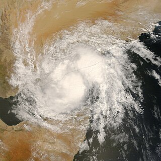
Deep Depression ARB 02 was a weak yet costly tropical cyclone which caused extensive damage and loss of life in Yemen. The sixth tropical cyclone and third deep depression of the 2008 North Indian Ocean cyclone season, ARB 02 formed in the Arabian Sea on October 19 from the same broader system which would spawn Moderate Tropical Storm Asma in the southern Indian Ocean around that time. Moving generally westward, the depression failed to intensify further, reaching maximum sustained winds of 55 km/h (35 mph). It would weaken, becoming a remnant low on October 23. Later that day, the system's remnants would made landfall near Ash Shihr in eastern Yemen.

<span class="mw-page-title-main">Cyclone Phet</span> North Indian cyclone in 2010

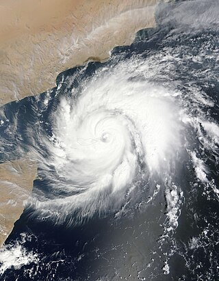
Very Severe Cyclonic Storm Phet was a powerful tropical cyclone that made landfall on Oman, Western India, and Pakistan. The third named cyclone of the 2010 cyclone season, Phet developed in the Arabian Sea on May 31 to the west of India. With conducive environmental conditions, the storm intensified to reach peak sustained winds of 155 km/h (95 mph) on June 2, based on analysis by the India Meteorological Department (IMD). On the next day, Phet dropped heavy rainfall while moving across eastern Oman, with a peak of 603 mm (23.7 in) in Qurayyat. The rains flooded arid areas and collected into wadis – normally dry river beds. Thousands of homes were wrecked across Oman. There were 24 fatalities in the country, and damage was estimated at US$780 million.

<span class="mw-page-title-main">1977 Oman cyclone</span> North Indian cyclone in 1977

The 1977 Oman cyclone was the deadliest tropical cyclone on record to strike Oman. The storm formed off the west coast of India in the Arabian Sea, and curved westward to reach peak winds of 110 km/h (68 mph). The storm struck Masirah Island and later southern Oman on June 13, before dissipating the next day over Saudi Arabia. Producing wind gusts to 230 km/h (140 mph), the storm was the strongest cyclone on record to hit the Arabian Peninsula until Cyclone Gonu hit in 2007. About 95% of Marisah Island was damaged by the strong winds, including much of the military base. The cyclone dropped 430.6 mm (16.95 in) of rainfall over a 24-hour period on Marisah, which was the highest daily total in the country as of 2003. Overall, the storm killed at least 105 people and left 50,000 homeless.

<span class="mw-page-title-main">Cyclone Keila</span> North Indian cyclone in 2011

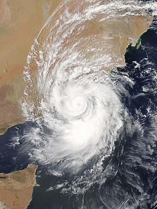
Cyclonic Storm Keila was the first named storm of the 2011 North Indian Ocean cyclone season. A weak system for much of its duration, Keila developed in the western Arabian Sea in late October 2011, amid an area of marginally favorable conditions. On November 2, it briefly organized enough to be classified as a cyclonic storm, which has maximum sustained winds of at least 65 km/h (40 mph). Given the name Keila by the India Meteorological Department (IMD), the storm quickly moved ashore southern Oman near Salalah, and weakened while meandering over the country. The remnants soon after moved offshore, dissipating on November 4.

<span class="mw-page-title-main">2015 North Indian Ocean cyclone season</span> North Indian Ocean tropical cyclone season

The 2015 North Indian Ocean cyclone season was an event in the annual cycle of tropical cyclone formation. The North Indian Ocean cyclone season has no official bounds, but cyclones tend to form between months of April and December, with the peak from May to November. These dates conventionally delimit the period of each year when most tropical cyclones form in the northern Indian Ocean.

<span class="mw-page-title-main">Cyclone Chapala</span> North Indian cyclone in 2015

Extremely Severe Cyclonic Storm Chapala was a powerful tropical cyclone that caused moderate damage in Somalia and Yemen during November 2015. Chapala was the third named storm of the 2015 North Indian Ocean cyclone season. It developed as a depression on 28 October off western India, and strengthened a day later into a cyclonic storm. Chapala then rapidly intensified amid favorable conditions. On 30 October, the India Meteorological Department (IMD) estimated that Chapala attained peak three-minute sustained winds of 215 km/h (135 mph). The American-based Joint Typhoon Warning Center (JTWC) estimated sustained winds of 240 km/h (150 mph), making Chapala among the strongest cyclones on record in the Arabian Sea. After peak intensity, Chapala skirted the Yemeni island of Socotra on 1 November, becoming the first hurricane-force storm there since 1922. High winds and heavy rainfall resulted in an island-wide power outage, and severe damage was compounded by Cyclone Megh, which struck Yemen a week later. Chapala means 'scrutiny' in Bengali.

<span class="mw-page-title-main">October 1996 India cyclone</span> North Indian Ocean cyclone in 1996

The October 1996 India cyclone had an unusual and protracted path that spanned much of the northern Indian Ocean. It originated in a weather disturbance that formed on October 14 in the southern Bay of Bengal, off India's east coast. Moving westward, it struck Andhra Pradesh on October 17 as a well-defined low-pressure area. It crossed southern India and reorganized in the Arabian Sea off the western coast of India. The system developed into a depression on October 22 and quickly intensified while moving northward. By October 24, the cyclone approached hurricane intensity as it developed an eye, reaching peak winds of at least 110 km/h (70 mph). On October 25, the storm abruptly stalled and weakened off Gujarat, and progressed southwestward as a minimal storm. It was no longer classifiable as a tropical cyclone by October 28, although its remnants persisted until November 2 when they dissipated east of Somalia.

<span class="mw-page-title-main">Cyclone Megh</span> North Indian cyclone in 2015

Extremely Severe Cyclonic Storm Megh is regarded as the worst tropical cyclone to ever strike the Yemeni island of Socotra, causing additional destruction there after Cyclone Chapala hit the same island. Megh formed on November 5, 2015, in the eastern Arabian Sea, and followed a path similar to Chapala. After moving northward, the cyclone turned to the west, and fueled by warm water temperatures, it quickly intensified. On November 7, the storm developed an eye in the center and began to rapidly intensify into a mature cyclone. By the next day, the India Meteorological Department estimated peak 3 minute sustained winds of 175 km/h (110 mph), and the American-based Joint Typhoon Warning Center estimated 1 minute winds of 205 km/h (125 mph). Shortly thereafter, the cyclone brushed the northern coast of Socotra. The storm steadily weakened thereafter, especially after it skirted the northern Somalia coast. After entering the Gulf of Aden, Megh turned to the west-northwest and struck southwestern Yemen on 10 November as a deep depression, dissipating shortly thereafter.

<span class="mw-page-title-main">2018 North Indian Ocean cyclone season</span> North Indian Ocean tropical cyclone season

The 2018 North Indian Ocean cyclone season was one of the most active North Indian Ocean cyclone seasons since 1992, with the formation of fourteen depressions and seven cyclones. The North Indian Ocean cyclone season has no official bounds, but cyclones tend to form between April and December, with the two peaks in May and November. These dates conventionally delimit the period of each year when most tropical cyclones form in the northern Indian Ocean.

<span class="mw-page-title-main">Cyclone Sagar</span> Tropical cyclone which made landfall in Somalia and Somaliland

Cyclonic Storm Sagar was the strongest tropical cyclone to make landfall in Somalia and Somaliland in recorded history until Gati in 2020, and the first named cyclone of the 2018 North Indian Ocean cyclone season. Forming on May 16 east of the Guardafui Channel, Sagar intensified into a cyclonic storm on the next day, as it gradually organized. The storm turned to the west-southwest and traversed the entirety of the Gulf of Aden, making landfall over Somaliland on May 19, farther west than any other storm on record in the North Indian Ocean. Sagar weakened into a remnant low on May 20.

<span class="mw-page-title-main">Cyclone Mekunu</span> Category 3 North Indian Cyclone in 2018

Extremely Severe Cyclonic Storm Mekunu was the strongest storm to strike Oman's Dhofar Governorate since 1959. The second named storm of the 2018 North Indian Ocean cyclone season, Mekunu developed out of a low-pressure area on May 21. It gradually intensified, passing east of Socotra on May 23 as a very intense tropical cyclone. On May 25, Mekunu reached its peak intensity. The India Meteorological Department estimated 10 minute sustained winds of 175 km/h (110 mph), making Mekunu an extremely severe cyclonic storm. The American-based Joint Typhoon Warning Center estimated slightly higher 1 minute winds of 185 km/h (115 mph). While at peak intensity, Mekunu made landfall near Raysut, Oman, on May 25. The storm rapidly weakened over land, dissipating on May 27.

<span class="mw-page-title-main">Cyclone Luban</span> Category 2 Indian ocean cyclone in 2018

Very Severe Cyclonic Storm Luban was the third tropical cyclone to affect the Arabian Peninsula during the 2018 North Indian Ocean cyclone season, after cyclones Sagar and Mekunu in May. Luban developed on October 6 in the central Arabian Sea, and for much of its duration, maintained a general west-northwestward trajectory. On October 10, the India Meteorological Department (IMD) upgraded Luban to a very severe cyclonic storm – equivalent to a Category 1 hurricane – and estimated maximum sustained winds of 140 km/h (85 mph). The storm made landfall on October 14 in eastern Yemen, as a cyclonic storm. The storm quickly weakened over the dry, mountainous terrain of the Arabian Peninsula, before dissipating on October 15.

<span class="mw-page-title-main">Cyclone Gati</span> North Indian Ocean cyclone in 2020

Very Severe Cyclonic Storm Gati was the strongest tropical cyclone on record to make landfall in Somalia, and one of few tropical cyclones to do so in the country. The seventh depression, third cyclonic storm, and second very severe cyclonic storm of the 2020 North Indian Ocean cyclone season, Gati formed from an area of low pressure in the Arabian Sea, on 21 November. The storm then explosively intensified, becoming a very severe tropical cyclone and reaching its peak intensity, the following day. Gati weakened slightly before making landfall in northeastern Somalia on 22 November. Gati was the first hurricane-force cyclone to make landfall in Somalia on record. Gati then weakened and became disorganized as it moved inland. The JTWC issued its final advisory on Gati shortly after it moved into the Gulf of Aden on 23 November. The name Gati was suggested by India, which means 'motion' in Hindi.

References

  1. 1 2 3 4 5 6 7 8 9 10 11 12 13 14 15 16 17 18 David Membery (April 1998). "An investigation into the causes and effects of the tropical storm which struck southern Arabia in June 1996". Weather. 53 (4): 106–110. Bibcode:1998Wthr...53..102M. doi: 10.1002/j.1477-8696.1998.tb03972.x .
  2. 1 2 3 4 5 6 Charles P. Guard; Gary B. Kubat (1997). 1996 Annual Tropical Cyclone Report (PDF) (Report). Hagåtña, Guam: Joint Typhoon Warning Center. p. 220. Retrieved 2015-11-06.
  3. RSMC New Delhi. Regional Specialised Meteorological Centre (RSMC) – Tropical Cyclones, New Delhi (PDF) (Report). India Meteorological Department. Archived from the original (PDF) on 2012-04-12. Retrieved 2015-04-24.
  4. Report on cyclonic disturbances over north Indian Ocean during 1996 (PDF) (Report). India Meteorological Department. January 1996. Retrieved 2015-11-06.
  5. Chris Jones (1996-06-18). "Weather Watch". London. The Guardian.  via Lexis Nexis (subscription required)
  6. 1 2 3 4 5 6 7 8 9 Republic of Yemen Flood Rehabilitation Project (PDF) (Report). World Bank. 1996-12-02. pp. 1–3. Retrieved 2015-11-15.
  7. "Floods Kill 65 in Yemen". Reuters. 1996-06-17. Retrieved 2015-11-15.
  8. 1 2 3 4 5 6 7 Yemen – Floods DHA-Geneva Situation Report No. 6, 4 July 1996 (Report). ReliefWeb. 1996-07-04. Retrieved 2015-11-14.{{cite report}}: Unknown parameter |agency= ignored (help)
  9. 1 2 Yemen – Floods DHA-Geneva Situation Report No. 5, 28 June 1996 (Report). ReliefWeb. 1996-06-28. Retrieved 2015-11-14.{{cite report}}: Unknown parameter |agency= ignored (help)
  10. 1 2 3 4 5 Implementation Completion Report on a Credit in the Amount of SDR 20.8 million (US$30 million Equivalent) to the Republic of Yemen for an Emergency Flood Rehabilitation Project (PDF) (Report). World Bank. 2002-05-22. pp. 1–4, 9. Retrieved 2015-11-16.
  11. 1 2 3 4 Yemen – Floods DHA-Geneva Situation Report No. 4, 24 June 1996 (Report). ReliefWeb. 1996-06-24. Retrieved 2015-11-14.{{cite report}}: Unknown parameter |agency= ignored (help)
  12. 1 2 3 4 5 6 7 8 Yemen – Floods DHA-Geneva Situation Report No. 7 23 July 1996 (Report). ReliefWeb. 1996-07-23. Retrieved 2015-11-14.{{cite report}}: Unknown parameter |agency= ignored (help)
  13. "1996 Flood Archive". Dartmouth College. Archived from the original on 2016-05-05. Retrieved 2015-11-14.
  14. Centre for Research on the Epidemiology of Disasters. "EM-DAT: The Emergency Events Database" . Université catholique de Louvain.
  15. Yemen – Floods DHA-Geneva Situation Report No. 2, 20 June 1996 (Report). ReliefWeb. 1996-06-20. Retrieved 2015-11-14.{{cite report}}: Unknown parameter |agency= ignored (help)
  16. Foodcrops and shortages No.3 , May/June 1996 (Report). ReliefWeb. 1996-06-20. Retrieved 2015-11-14.{{cite report}}: Unknown parameter |agency= ignored (help)
  17. Yemen – Floods DHA-Geneva Situation Report No. 3, 21 June 1996 (Report). ReliefWeb. 1996-06-21. Retrieved 2015-11-14.{{cite report}}: Unknown parameter |agency= ignored (help)
Cyclone 02A
02A Jun 11 1996 0255Z.png
Cyclone 02A approaching Oman on July 11