
The 2001 Gujarat earthquake, also known as the Bhuj earthquake, occurred on 26 January at . The epicentre was about 9 km south-southwest of the village of Chobari in Bhachau Taluka of Kutch (Kachchh) District of Gujarat, India.

The Great Sumatran fault, also known as Semangko fault, is a large strike-slip fault running the entire length of the island of Sumatra. This Indonesian island is located in a highly seismic area of the world, including a subduction zone off the west coast of the island.
An earthquake occurred on 31 May 1935 between 2:30 am and 3:40 am at Quetta, Baluchistan Agency, close to the border with southern Afghanistan. The earthquake had a magnitude of 7.7 Mw and anywhere between 30,000 and 60,000 people died from the impact. It was recorded as the deadliest earthquake to strike South Asia until 2005. The quake was centred 4 km south-west of Ali Jaan, Balochistan, British India.

The 2002 Hindu Kush earthquakes struck in northern Afghanistan during the month of March. At least 166 people were killed with a very large and intermediate-depth mainshock on March 3. Three weeks later, at least 1,200 were killed during a moderate but shallow event that had a maximum Mercalli intensity of VII. The M7.4 and M6.1 reverse events were focused in the Hindu Kush mountain range area.

The 2008 Ziarat earthquakes hit the Pakistani province of Balochistan on October 29 with a moment magnitude of 6.4. The US Geological Survey reported that the first earthquake occurred 60 km (37 mi) north of Quetta and 185 km (115 mi) southeast of the Afghanistan city of Kandahar at 04:09 local time at a depth of 15 km (9.3 mi), at 30.653°N, 67.323°E. It was followed by another shallower magnitude 6.4 earthquake at a depth of 14 km (8.7 mi) approximately 12 hours after the initial shock, at 30.546°N, 67.447°E. 215 people were confirmed dead. More than 200 were injured, and 120,000 were rendered homeless. Qamar Zaman Chaudhry, director general of Pakistan Meteorological Department, stated the quake epicenter was 70 miles (110 km) north of Quetta, and about 600 km (370 mi) southwest of Islamabad.

The 2013 Bushehr earthquake occurred with a moment magnitude of 6.3 on April 9 in Iran. The shock's epicenter was in the province of Bushehr, near the city of Khvormuj and the towns of Kaki and Shonbeh. At least 37 people were killed, mostly from the town of Shonbeh and villages of Shonbeh-Tasuj district, and an estimated 850 people were injured.
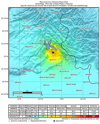
The 2019 Kashmir earthquake struck regions of Pakistan with an epicentre in Azad Kashmir on 24 September at 16:02 local time. It had a magnitude of 5.4 and a maximum felt intensity of VII on the Modified Mercalli intensity scale or VIII on the European macroseismic scale. There was severe damage in Mirpur District, causing the deaths of 40 people and injuring a further 850. The epicentre of the shallow quake was near the city of Mirpur, Pakistan. The tremors were felt in the Kashmir region, Punjab (Pakistan), Punjab (India), Uttarakhand and northern parts of India including New Delhi.
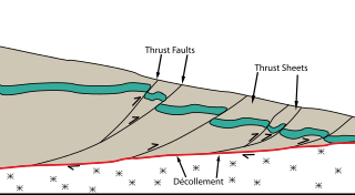
The Main Himalayan Thrust (MHT) is a décollement under the Himalaya Range. This thrust fault follows a NW-SE strike, reminiscent of an arc, and gently dips about 10 degrees towards the north, beneath the region. It is the largest active continental megathrust fault in the world.
The 2021 Assam earthquake struck 11 km away from Dhekiajuli, Assam, India at 07:51 (IST) on April 28, 2021 with a moment magnitude of 6.0 at 34.0 km (21.1 mi) depth. The quake struck with an epicenter 140 km north of the main city of Guwahati. It resulted in two fatalities and at least 12 injuries.
On July 10 2021, a 5.7 magnitude earthquake struck 20 km southeast of the Rasht Valley in Tajikistan.
The 2021 Luxian earthquake was a damaging seismic event occurring in the early hours of September 16 at 04:33 China Standard Time. The surface-wave magnitude (Ms ) 6.0 or moment magnitude (Mw ) 5.4 earthquake struck at a shallow depth of 7.5 km and severe shaking in an area of 4,000 square kilometers was assigned a maximum intensity of VIII on the China seismic intensity scale. Three people were killed and 146 injured when the earthquake struck Lu County, Luzhou, Sichuan Province. At least 36,800 buildings were affected, 7,800 of them seriously damaged or completely destroyed, causing about a quarter of a billion dollars worth of damage.
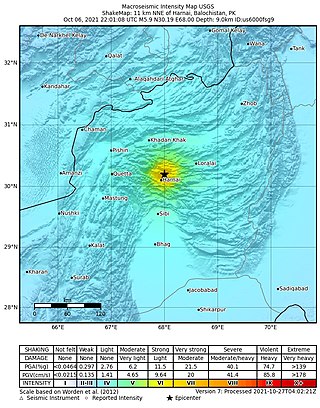
An earthquake struck Pakistan's province of Balochistan near the city of Harnai on 7 October 2021. The moment magnitude 5.9 Mww quake struck in the early morning at 03:01 local time, killing at least 42 people and injuring 300 others. The earthquake occurred just one day before the anniversary of the 2005 Kashmir earthquake.
The 1654 Tianshui earthquake occurred on July 21 in Tianshui, Gansu Province, Ming dynasty sometime between 21:00 and 23:00 local time. The event had an estimated moment magnitude of 7.0 and was assigned a maximum intensity of XI on the China seismic intensity scale. Resulting in extreme damage and affecting at least four provinces, the quake killed approximately 30,000 people.
The 1885 Kashmir earthquake, also known as the Baramulla earthquake occurred on 30 May in Srinagar. It had an estimated moment magnitude of Mw 6.3–6.8 and maximum Medvedev–Sponheuer–Karnik scale intensity of VIII (Damaging). At least 3,081 people died and severe damage resulted.
The 1980 Nepal earthquake devastated the Nepal–India border region on the evening of July 29. The epicenter of the 6.6 earthquake was located in Nepal, northwest of Khaptad National Park. At least 200 people died and 5,600 were injured in the disaster. Extensive damage occurred on both sides of the border, amounting to 245 million USD.
In November 2002, two medium-sized earthquakes struck northern Pakistan, causing major damage in Baltistan region and killing 41 people.
The 2022 Hormozgan earthquakes were doublet earthquakes that struck southern Iran on 1 July 2022. The earthquakes, which occurred around two hours apart, killed seven people and injured dozens more.
The 1977 Naghan earthquake struck Chaharmahal and Bakhtiari province in Iran on April 6 at 13:36 UTC. The earthquake measuring 6.0 Mw occurred at a depth of 15 km (9.3 mi) and had a maximum Modified Mercalli intensity of VIII (Severe). More than 2,100 homes were destroyed and at least 348 people died.
On September 5, 2022, a reverse faulting earthquake with a moderate magnitude of 5.1 struck Kunar Province, Afghanistan, close to the city of Jalalabad.
The 1957 Farsinaj earthquake struck Hamadan province, Iran on 13 December at 05:15 local time. The moment magnitude 6.5 earthquake struck at a depth of 15 km (9.3 mi). The epicenter of the earthquake was located in the seismically active Zagros Mountains. The mountain range was also the location for several historic earthquakes. The earthquake occurred near two segments of the active strike-slip Main Recent Fault. At least 1,130 people died, including over 700 in the village of Farsinaj. Additional deaths also occurred in Dehasiyab, Sarab, and other villages. The earthquake left an estimated 15,000 homeless; poor weather conditions including a winter storm on 21 December killed another 20 people. Several deadly and damaging aftershocks in that month killed a total of 38 people.

