2006 New England flood

Last updated
A NEXRAD radar animation of the storm on May 12, 2006 NEFlooding2006.gif
A NEXRAD radar animation of the storm on May 12, 2006

The New England Flood of May 2006, often locally referred to as the Mother's Day Flood, was a flood event that occurred in New England, especially in New Hampshire and Massachusetts, during the month of May, 2006. It started on May 11, 2006 as a result of an unusually strong low pressure system that stalled over the central United States, drawing copious amounts of moisture from the Atlantic Ocean. Most of this moisture was drawn directly over New England, producing continuous heavy rain that led to record flooding near several rivers. It was described as the worst flooding since the New England Hurricane of 1938. [1] There were at least two fatalities, both in Topsfield, Massachusetts. [2] [3] Some called it the Mother's Day Flood, since it occurred on that holiday.

Contents

Impact

Rainfall totals for May 11, 2006 to May 18, 2006. NEFlooding2006 7day Rainfall.gif
Rainfall totals for May 11, 2006 to May 18, 2006.

Hundreds of residents were evacuated from their homes as the waters rose. Several communities saw extensive flooding, particularly along the Merrimack River. Much of New England was under a flood warning or flash flood warning at some point in time.

The governors of Maine, Massachusetts and New Hampshire each declared a state of emergency for all or part of their respective states as a result of the flooding. [4]

Connecticut

Compared to farther north and east, the flooding was relatively minor in Connecticut. It was most notable in low-lying areas along the Connecticut River. [5]

Maine

Extreme southern Maine saw significant flooding, especially around the Mousam River, where evacuations were underway as the river rose quickly. Downtown York Beach was underwater, and severe flooding was also reported in the Kennebunk area.

The Spaulding Dam along the lower Salmon Falls River near Lebanon was also in danger of bursting, which led to the evacuation of portions of the community. [6]

Massachusetts

Merrimack River from University Avenue Bridge in Lowell, looking downriver Merrimack River - View from University Avenue Bridge in Lowell.jpg
Merrimack River from University Avenue Bridge in Lowell, looking downriver

Numerous rivers overflowed in northeastern Massachusetts, and urban flooding also occurred. Thousands of people were evacuated and water was reported to be up to the rooftops of several homes. [7] Several rivers, including the Merrimack and Charles rivers, threatened several communities. The Merrimack in Lowell was expected to reach more than 8 feet (2.4 m) above flood stage combined with 15 inches (380 mm) of rain.

The Merrimack River during flooding in May 2006 in Haverhill, Massachusetts Flooded merrimack.jpg
The Merrimack River during flooding in May 2006 in Haverhill, Massachusetts

The flooding also led to drowned waste water treatment plants, which overwhelmed sewage systems. Burst pipes in Haverhill dumped 35 million gallons (132,000 m³) of waste a day into the Merrimack River. In addition, the flooding at another regional treatment plant in Lawrence was also very close to shutting down the power there, which would have sent sewage into the Merrimack at a rate of 115 million gallons (435,000 m³) a day. [6] For only the third time in a 150-year history, Lowell dropped its flood-controlling Francis Gate. Also, most notably in downtown Peabody, people could even be seen sailing in boats atop flooded areas.

Governor Mitt Romney toured the hard-hit community of Peabody on May 15 and described the situation as historic. "This is a level of crisis which is beyond anything these communities have ever experienced from water in their history". On Good Morning America the next day, Romney described the flooding as "almost Biblical" and said "We're sort of making jokes about Noah and taking two of each kind of animal because we haven't ever seen rain like this." [8]

Numerous roads, including a busy section of US 1, were closed due to flooding. The Route 495 exit at Route 114 was also closed, the entire area under several feet of water. At that area, several businesses were damaged, including a Friendlys, a 7–11 and the first floor of a hotel. [6]

New Hampshire

Turkey River crossing in Concord, NH, following the flood TurkeyRiverIronWorksRd2006.jpg
Turkey River crossing in Concord, NH, following the flood
Merrimack River (Goffs Falls) Gage, Manchester, NH GoffsFallsFlood2006.gif
Merrimack River (Goffs Falls) Gage, Manchester, NH
Piscataquog River Dam Gage, Goffstown, NH PiscataquagFlood2006.gif
Piscataquog River Dam Gage, Goffstown, NH

The most serious flooding in New Hampshire was along the Merrimack River. Dozens of homes were flooded, especially in Manchester where the Merrimack was 10 feet (3 m) above flood stage. Electricity was cut along several sections of the river, and flooding was reported in Concord, Merrimack, Hooksett, Fremont and Raymond among other communities. At least 600 roads were closed due to flooding. Flooding of the Turkey River also caused St. Paul's School in Concord to be closed. [9] [10] [11]

There were serious concerns along the Salmon Falls River in Milton, where a dam was dangerously close to failing and causing extreme flooding downstream. Several other dams, including the Newmarket Dam on the Lamprey River, were also being watched, with local residents being evacuated downstream. [12] The Suncook River, responding to the highest rainfall amounts in at least 70 years (more than 8 inches (200 mm) dropped by the system in three days on Concord), rose to flood level and backed up behind an old mill dam, which produced a shallowly-sloping pool that overtopped a sand and gravel quarry, connected with a downstream section of channel, and cut a new shorter channel at 25–50 meters per hour in the town of Epsom. [13] Two previous channels, around Bear Island, were left dry. The new river course, approximately a mile long, is the largest channel change in a river in New Hampshire since systematic topographic mapping began in the state in the early 20th century. [14]

In addition, at least 550 National Guard troops were deployed in the state. Damage in New Hampshire was estimated to be well into the tens of millions of dollars. [15]

Related Research Articles

<span class="mw-page-title-main">Lawrence, Massachusetts</span> City in Massachusetts, United States

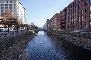
Lawrence is a city located in Essex County, Massachusetts, United States, on the Merrimack River. At the 2020 census, the city had a population of 89,143. Surrounding communities include Methuen to the north, Andover to the southwest, and North Andover to the east. Lawrence and Salem were the county seats of Essex County, until the state abolished county government in 1999. Lawrence is part of the Merrimack Valley.

<span class="mw-page-title-main">Allenstown, New Hampshire</span> Town in New Hampshire, United States

Allenstown is a town in Merrimack County, New Hampshire, United States. The population was 4,707 at the 2020 census, up from 4,322 at the 2010 census. Allenstown includes a portion of the village of Suncook. Just over one-half of the town's area is covered by Bear Brook State Park.

<span class="mw-page-title-main">Pembroke, New Hampshire</span> Town in New Hampshire, United States

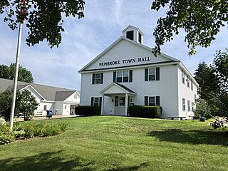
Pembroke is a town in Merrimack County, New Hampshire, United States. The population was 7,207 at the 2020 census. Pembroke includes part of the village of Suncook. The center of population of New Hampshire is close to the Pembroke town center.

<span class="mw-page-title-main">Suncook, New Hampshire</span> Census-designated place in New Hampshire, United States

Suncook is a census-designated place (CDP) in Merrimack County, New Hampshire, United States. The population was 5,501 at the 2020 census. Approximately two-thirds of Suncook is located in the town of Pembroke, with the remainder in Allenstown.

<span class="mw-page-title-main">Merrimack River</span> River in New Hampshire and Massachusetts, United States

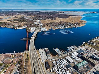
The Merrimack River is a 117-mile-long (188 km) river in the northeastern United States. It rises at the confluence of the Pemigewasset and Winnipesaukee rivers in Franklin, New Hampshire, flows southward into Massachusetts, and then flows northeast until it empties into the Gulf of Maine at Newburyport. From Pawtucket Falls in Lowell, Massachusetts, onward, the Massachusetts–New Hampshire border is roughly calculated as the line three miles north of the river.

<span class="mw-page-title-main">Concord River</span> River in Massachusetts, United States

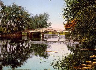
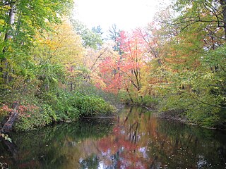
The Concord River is a 16.3-mile-long (26.2 km) tributary of the Merrimack River in eastern Massachusetts, United States. The river drains a small rural and suburban region northwest of Boston. As one of the most notable small rivers in U.S. history, it was the scene of an important early battle of the American Revolutionary War and was the subject of a 19th-century book by Henry David Thoreau.

<span class="mw-page-title-main">Middlesex Canal</span> Barge canal in eastern Massachusetts, US

The Middlesex Canal was a 27-mile (44-kilometer) barge canal connecting the Merrimack River with the port of Boston. When operational it was 30 feet wide, and 3 feet deep, with 20 locks, each 80 feet long and between 10 and 11 feet wide. It also had eight aqueducts.

The Frederick E. Everett Turnpike, also called the Central New Hampshire Turnpike, is a toll road in the U.S. state of New Hampshire, running 44 miles (71 km) from the Massachusetts border at Nashua north to Concord. The Everett Turnpike is named for Frederick Elwin Everett, the first commissioner of the New Hampshire Department of Transportation.

<span class="mw-page-title-main">New Hampshire Route 28</span> State highway in eastern New Hampshire, US

New Hampshire Route 28 is an 85.413-mile-long (137.459 km) north–south state highway in eastern New Hampshire. It connects the town of Ossipee in east-central New Hampshire with Salem on the Massachusetts border, while passing through Manchester, the largest city in the state.

<span class="mw-page-title-main">Assabet River</span> River in the United States

The Assabet River is a small, 34.4-mile (55.4 km) long river located about 20 miles (30 km) west of Boston, Massachusetts, United States. The Assabet rises from a swampy area known as the Assabet Reservoir in Westborough, Massachusetts, and flows northeast before merging with the Sudbury River at Egg Rock in Concord, Massachusetts, to become the Concord River. The Organization for the Assabet, Sudbury and Concord Rivers, headquartered in West Concord, Massachusetts, is a non-profit organization dedicated to the preservation, protection, and enhancement of the natural and recreational features of these three rivers and their watershed. As the Concord River is a tributary of the Merrimack River, it and the Assabet and Sudbury rivers are part of the larger Merrimack River watershed.

The Pennacook, also known by the names Penacook and Pennacock, were an Algonquian-speaking Indigenous peoples of the Northeastern Woodlands who lived in Massachusetts, New Hampshire, and southern Maine. They were not a united tribe but a network of politically and culturally allied communities. Penacook was also the name of a specific Native village in what is now Concord, New Hampshire.

<span class="mw-page-title-main">Mill River (Northampton, Massachusetts)</span> Tributary of the Connecticut River in Hampshire County, Massachusetts, USA

The Mill River is a 13.5-mile-long (21.7 km) tributary of the Connecticut River arising in the western hilltowns of Hampshire County, Massachusetts. It is notable for dropping in elevation, along with its West Branch, more than 700 feet (210 m) over 15 miles (24 km).

<span class="mw-page-title-main">Suncook Lakes</span> Pair of lakes located in Belknap County

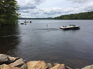
The Suncook Lakes are a pair of lakes located in Belknap County in central New Hampshire, United States, in the town of Barnstead. Upper Suncook Lake encompasses 402 acres (1.63 km2), while Lower Suncook Lake covers 295 acres (1.19 km2). The lakes are connected by a 1,000-foot-long (300 m) channel, spanned by a road bridge. A dam at the outlet of Lower Suncook Lake controls the water level of both lakes. The lakes are located along the Suncook River, a tributary of the Merrimack River. There are three islands on Lower Lake.

<span class="mw-page-title-main">Turkey River (New Hampshire)</span> River in New Hampshire, United States

The Turkey River is a 6.1-mile-long (9.8 km) stream located in southern New Hampshire in the United States. It is a tributary of the Merrimack River, which flows to the Gulf of Maine.

<span class="mw-page-title-main">Suncook River</span> River in New Hampshire, United States

The Suncook River is a 35.7-mile-long (57.5 km) river located in central New Hampshire in the United States. It is a tributary of the Merrimack River, which flows to the Gulf of Maine.

<span class="mw-page-title-main">2006 Mid-Atlantic United States flood</span>

The Mid-Atlantic United States flood of 2006 was a significant flood that affected much of the Mid-Atlantic region of the eastern United States. The flooding was very widespread, affecting numerous rivers, lakes and communities from Upstate New York to North Carolina. It was widely considered to be the worst flooding in the region since Hurricane David in 1979. It was also one of the worst floodings in the United States since Hurricane Katrina in August 2005. At least 16 deaths were related to the flooding.

<span class="mw-page-title-main">West Hopkinton, New Hampshire</span> Populated place in New Hampshire, United States

West Hopkinton is a populated place within the town of Hopkinton in Merrimack County, New Hampshire, United States. West Hopkinton is well known for its agricultural center, preservation of historical landmarks and recreational activities within the village.

Floods in the United States before 1900 is a list of flood events that were of significant impact to the country, before 1900. Floods are generally caused by excessive rainfall, excessive snowmelt, and dam failure.

<span class="mw-page-title-main">Avulsion (river)</span> Rapid abandonment of a river channel and formation of a new channel

In sedimentary geology and fluvial geomorphology, avulsion is the rapid abandonment of a river channel and the formation of a new river channel. Avulsions occur as a result of channel slopes that are much less steep than the slope that the river could travel if it took a new course.

<span class="mw-page-title-main">Merrimack Valley</span> Region in the U.S. states of New Hampshire and Massachusetts

The Merrimack Valley is a bi-state region along the Merrimack River in the U.S. states of New Hampshire and Massachusetts. The Merrimack is one of the larger waterways in New England and has helped to define the livelihood and culture of those living along it for millennia.

References

  1. [ dead link ]
  2. Deluge! An Eyewitness Account of the Mother’s Day Storm of 2006 Historic Ipswich
  3. Obituary of Melvin Hughes Tribute Archive
  4. [ dead link ]
  5. [ dead link ]
  6. 1 2 3 Portions of New England submerged after record rainfall. whdh.com (May 16, 2006)
  7. [ dead link ]
  8. New England sees worst floods in 70 years. USA Today (May 17, 2006)
  9. Brown, Jana (18 May 2006). "Timeline, Stories of the Flood". St. Paul's School. Retrieved 19 March 2021.
  10. Zezima, Katie (16 May 2006). "New England Deluged by Worst Flooding in Decades". The New York Times. Retrieved 19 March 2021.
  11. Tirrell-Wysocki, David. "The Associated Press Flooding closing St. Paul's School; students flying home". Boston.com. The Boston Globe. Retrieved 19 March 2021.
  12. Crews Watch Dams As Rivers Surge – New Hampshire Weather News Story. WMUR Manchester (May 15, 2006)
  13. Perignon, M. C. (2007). Mechanisms governing avulsions in transient landscapes: Analysis of the May 2006 Suncook River Avulsion in Epsom, New Hampshire (S.B. Thesis). Massachusetts Institute of Technology.
  14. Alarkon, Walter (June 4, 2006). "A river doesn't run through it". concordmonitor.com. Concord Monitor. Archived from the original on March 3, 2016. Retrieved May 26, 2022.
  15. New England Floodwaters Begin To Drop – New Hampshire Weather News Story. WMUR Manchester (May 16, 2006)