It is proposed that this article be deleted because of the following concern:
If you can address this concern by improving, copyediting, sourcing, renaming, or merging the page, please edit this page and do so. You may remove this message if you improve the article or otherwise object to deletion for any reason. Although not required, you are encouraged to explain why you object to the deletion, either in your edit summary or on the talk page. If this template is removed, do not replace it . The article may be deleted if this message remains in place for seven days, i.e., after 12:32, 4 December 2018 (UTC).
Nominator: Please consider notifying the author/project: {{subst:proposed deletion notify |2007 Guatemala earthquake|concern=[[Wikipedia:WikiProject Earthquakes|WikiProject Earthquakes]] is not documenting insignificant events like this one, either as standalone articles ''or'' as list entries. Our efforts are instead being focused on creating complete, interesting, and encyclopedic articles that require significant coverage. This one fails multiple aspects of [[WP:EVENT]] and our own [[Wikipedia:Notability (earthquakes)|notability guidelines]] because of the following concerns: *Minor event in a region with no shortage of large, very large, and great destructive earthquakes.}} ~~~~ |
 | |
| UTC time | ?? |
|---|---|
| ISC event | |
| USGS-ANSS | |
| Date * | June 13, 2007 |
| Local date | |
| Local time | |
| Magnitude | 6.7 Mw |
| Depth | 23 km (14 mi) [1] |
| Epicenter | 13°33′N90°37′E / 13.55°N 90.62°E Coordinates: 13°33′N90°37′E / 13.55°N 90.62°E [1] |
| Type | Reverse [1] |
| Areas affected | Guatemala |
| Max. intensity | VI (Strong) [1] |
| Casualties | None |
The 2007 Guatemala earthquake occurred on June 13 at 13:29:46 local time. The epicenter was located in the Pacific Ocean, south of Puerto Quetzal, about 115 kilometres (71 mi) south-southwest of Guatemala City.
The epicenter, epicentre or epicentrum in seismology is the point on the Earth's surface directly above a hypocenter or focus, the point where an earthquake or an underground explosion originates.

Puerto Quetzal is Guatemala's largest Pacific Ocean port. It is important for both cargo traffic and as a stop-off point for cruise liners.
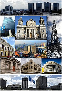
Guatemala City, locally known as Guatemala or Guate, officially Nueva Guatemala de la Asunción, is the capital and largest city of Guatemala, and the most populous in Central America. The city is located in the south-central part of the country, nestled in a mountain valley called Valle de la Ermita. It is estimated that its population is about 1 million. Guatemala City is also the capital of the Municipality of Guatemala and of the Guatemala Department.
The quake was reportedly felt in Guatemala, El Salvador and parts of Mexico. The quake caused a minor landslide on the Inter-American Highway, and a small number of houses were reported to have been damaged or destroyed along Guatemala's south coast, [2] but there were no reports of major damage or casualties. [1]

Mexico, officially the United Mexican States, is a country in the southern portion of North America. It is bordered to the north by the United States; to the south and west by the Pacific Ocean; to the southeast by Guatemala, Belize, and the Caribbean Sea; and to the east by the Gulf of Mexico. Covering almost 2,000,000 square kilometres (770,000 sq mi), the nation is the fifth largest country in the Americas by total area and the 13th largest independent state in the world. With an estimated population of over 120 million people, the country is the eleventh most populous state and the most populous Spanish-speaking state in the world, while being the second most populous nation in Latin America after Brazil. Mexico is a federation comprising 31 states and Mexico City, a special federal entity that is also the capital city and its most populous city. Other metropolises in the state include Guadalajara, Monterrey, Puebla, Toluca, Tijuana and León.
While the USGS assigned a magnitude of 6.7 for this event, many local seismological agencies in Guatemala, [3] El Salvador and Nicaragua only registered the quake in the 5.5–6.0 range.[ citation needed ] These calculations are more accurate due to the seismographs' locations closer to the epicenter, and are in agreement with the minor shaking reported by residents.[ citation needed ]

Nicaragua, officially the Republic of Nicaragua, is the largest country in the Central American isthmus, bordered by Honduras to the northwest, the Caribbean to the east, Costa Rica to the south, and the Pacific Ocean to the southwest. Managua is the country's capital and largest city and is also the third-largest city in Central America, behind Tegucigalpa and Guatemala City. The multi-ethnic population of six million includes people of indigenous, European, African, and Asian heritage. The main language is Spanish. Indigenous tribes on the Mosquito Coast speak their own languages and English.
In addition, the USGS coins all movements as earthquakes, while in Latin America, small movements such as this one are called tremors ("temblores" in Spanish). [4]