
European route E 4 passes from north to south through Sweden from the border with Finland, with a total length of 1,590 kilometres (990 mi). The Finnish part lies entirely within Tornio in northern Finland, and is only 1 kilometre (0.62 mi) long. The Swedish part traverses most of Sweden except the extreme north and the west coast region, and is commonly considered the highway backbone of Sweden, since it passes in the vicinity of many of its largest cities and through the capital Stockholm. In particular, it is the mainline road used by most vehicle traffic, both personal cars and freight trailers, between the north (Norrland) and southern Sweden or beyond.
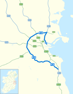
The M50 motorway is a C-shaped orbital motorway in Dublin and the busiest motorway in Ireland. The current route was built in various sections over the course of 27 years, from 1983 to 2010. It begins at Dublin Port, running northward through the Dublin Port Tunnel and along a portion of the Airport Motorway. It then turns west at its junction with the M1, circling the northern, western and southern suburbs of Dublin, before merging with the M11 at Shankill in South East Dublin. The road forms part of European route E01.
The N7 road is a national primary road in Ireland, connecting Limerick and Dublin. The majority of the route is motorway standard and is designated as the M7 motorway. At the Rosbrien interchange in Limerick the route continues as the N18 dual carriage to Shannon and Ennis. The road passes through the midlands of Ireland, and acts as a trunk route out of Dublin for the N8 and N9 national primary routes to Cork and Waterford respectively. It forms part of European route E20.
The Sydney Orbital Network is a 110 kilometre motorway standard ring road or orbital around the city of Sydney, the capital of New South Wales in Australia. It runs north from Sydney Airport, underneath the CBD to the North Shore, west to the Hills District, south to Prestons and then east to connect with the airport. Much of the road is privately owned and financed by tolls.

A limited-access road, known by various terms worldwide, including limited-access highway, dual-carriageway, expressway, and partial controlled access highway, is a highway or arterial road for high-speed traffic which has many or most characteristics of a controlled-access highway, including limited or no access to adjacent property, some degree of separation of opposing traffic flow, use of grade separated interchanges to some extent, prohibition of some modes of transport such as bicycles or horses, and very few or no intersecting cross-streets. The degree of isolation from local traffic allowed varies between countries and regions. The precise definition of these terms varies by jurisdiction.

The Autostrade are roads forming the Italian national system of motorways. The total length of the system is about 6,758 kilometres (4,199 mi). In North and Central Italy, the Autostrade mainly consists of tollways, with the biggest portion in concession to the Atlantia group which operates some 3,408 km. Other operators include ASTM, ATP, and Autostrade Lombarde in the north-west; Autostrada del Brennero, A4 Holding, Concessioni Autostradali Venete, and Autovie Venete in the north-east; Strada dei Parchi, SALT, SAT, and Autocisa in the center; and CAS in the south all under the supervision of the state-owned ANAS.

A controlled-access highway is a type of highway which has been designed for high-speed vehicular traffic, with all traffic flow ingress- and egress-regulated. Common English terms are freeway, motorway and expressway. Other similar terms include Interstate and parkway. Some of these may be limited-access highways, although this term can also refer to a class of highway with somewhat less isolation from other traffic.

The M0 motorway is a ringroad around Budapest, the capital of Hungary. The ring presently connects motorways M1, M7, M6, M5, M4, M3, M2, connecting currently to Highway 11. The whole length of the motorway is planned at about 108 km. About 78 km have been completed as of 2013.

The Southern Cross Drive is a 4.8 km (3 mi) dual carriage untolled motorway in Sydney, New South Wales, Australia. Part of the M1 and Sydney Orbital Network, the road, a freeway that opened in 1969, links the Eastern Distributor and South Dowling Street at Kensington in the north to General Holmes Drive at Sydney Airport in the south.

The A72 is an autoroute (motorway) in France. It is 55 kilometres (34 mi) long.

Port of Brisbane Motorway is a motorway, which connects the Port of Brisbane to the Gateway Motorway. Stage 1 was opened in December 2002. The motorway was built to take freight traffic off Lytton Road, with about 4,000 vehicles travelling to the Port of Brisbane in 2002. Stage 1 cost A$196 million and was finished six months ahead of schedule and A$20 million under budget. The Port of Brisbane Motorway holds the M4 motorway designation

The R110 road is a regional road in Ireland which goes from St Stephen's Green to Red Cow, Dublin. Its route is completely within the Dublin urban area.
This is a list of freeways in Australia, sorted by states and territories and their corresponding routes. This list includes tollways / toll roads such as the CityLink freeway system in Melbourne. This list has over 70 entries. The only jurisdiction in Australia without freeways is the Northern Territory. Victoria has the largest and densest freeway network in Australia.

The A12 is an Italian autostrada (motorway), composed of two unconnected parts. The first one connects Genoa and Rosignano Marittimo, the second connects Civitavecchia and Rome.
Highways in the Czech Republic are managed by the state-owned Road and Motorway Directorate of the Czech Republic – ŘSD ČR, established in 1997. The ŘSD currently (2018) manages and maintains 1,250 km of motorways (dálnice), whose speed limit is of 130 km/h or 80 mph. The present-day national motorway network is due to be of about 2,000 km before 2030.

Denmark has three general speed limits:

Sweden has speed limits ranging from 30 km/h to 120 km/h, where 30, 40, 50, 60 and 70 km/h are used within towns and cities. Outside schools and hospitals the limit is often 30 km/h. 70, 80, 90 and 100 km/h are mainly used outside built-up areas where the speed limit depends on the standard and safety of the road. 90 and 100 km/h are used mainly on roads with separated lanes, however local exceptions may apply, mainly in northern Sweden, where 100 km/h (62 mph) is legal on roads with no separated lanes and where the standard of the road often is poor. The main reason for setting 100 km/h on these roads is because of their high importance to the region. Earlier it was permitted to drive 110 km/h (68 mph) on these roads but due to the poor standards the speed limit was lowered to 100 km/h in 2008.

Otoyol 20, abbreviated as , a.k.a. Ankara Çevreyolu, is a motorway in Ankara, Turkey that forms the ring road of the city. The 110 km (68 mi) long beltway connects in the northwest to the Anatolia Motorway , and it will connect in the south to Ankara-Adana Motorway after its completion.


