You can help expand this article with text translated from the corresponding article in French. (July 2023)Click [show] for important translation instructions.
Machine translation, like DeepL or Google Translate, is a useful starting point for translations, but translators must revise errors as necessary and confirm that the translation is accurate, rather than simply copy-pasting machine-translated text into the English Wikipedia.
Do not translate text that appears unreliable or low-quality. If possible, verify the text with references provided in the foreign-language article.
You must provide copyright attribution in the edit summary accompanying your translation by providing an interlanguage link to the source of your translation. A model attribution edit summary is Content in this edit is translated from the existing French Wikipedia article at [[:fr:Autoroute A51 (France)]]; see its history for attribution.
You may also add the template {{Translated|fr|Autoroute A51 (France)}} to the talk page.
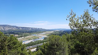
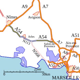
Its main section connects Marseille to Aix-en-Provence and the Durance Valley to the north of Sisteron (Saulce). Only 18km is toll free between Marseilles and Aix-en-Provence, the remaining 128km is a toll road operated by Escota between Aix-en-Provence and Saulce. At Aix-en-Provence, the autoroute becomes briefly the N296 dual-carriageway between the exits Jas-de-Boufan and Aix-les-Platanes. This section where it meets the N7 was originally proposed to be an autoroute but building has subsequently compromised the route. There is a speed limit of 50km/h on part of the N296.
A section at the Grenoble end, Varces to Coynelle (17km), was opened in July 1999. This was extended in March 2007 when the next section, connecting Coynelle to the Col du Fau (10.5km), was opened in March 2007. This includes 4.5km which is a single carriageway through the Tunnel of Sinard and over the Viaduct de Monestier. This northern section is also a toll road but it is operated by AREA. This has greatly reduced the summer congestion through the commune of Monestier.
This article contains a bulleted list or table of intersections which should be presented in a properly formatted junction table. Please consult this guideline for information on how to create one. Please improve this article if you can.(December 2021)
11 (St-Paul de Varces) Towns served: St-Paul de Varces, Le Gua
10 (Varces) Towns served: Varces
Exchange A51-A480 Junction with the A480 to Grenoble, Chambéry and Lyon.
History
The first section was built in 1953, it connected the Autoroute de nord (open in 1951) to Cabriès. It was only extended to Aix-en-Provence and the A8 in 1970. The construction of the section from Grenoble to Sisteron was subject to protests because of its environmental impact. In 1995 for example, demonstrators blocked work by chaining themselves to construction equipment.
Future
Following many ministerial and policy changes, and tensions between local residents. As a result, the completion of the motorway has been on the agenda for 20 years.
Were all the sections are completed the road journey from Grenoble-Marseille would be 2h40 (instead of the current 3h30). However, there are several problems:
The design of the road
The class of roads (toll/free autoroute, expressway or upgrade of the current roads (N75 and N85)
The cost of the project.
Strong environmental impact of the route.
The motorway must pass through the middle of the South-Dauphiné (Trièves) Alps. There were two options for the route between the Col de Fau (Monestier-de-Clermont) and the end of the southern section near Gap:
The "High Route" was the most direct route over several high passes to Sisteron (The budget at the time was envisaged at 1.8 billion euros)
"Gap East" (via the Drac valley, the Col de Bayard and the Avance valley) to Saulce the current end of the motorway from Marseille (the budget was envisaged to be approximately 2.2 billion euros).
Following a public inquiry organized between 2005 and 2006, the Minister Mr Perben announced in 2006 that A51 would be built on the Gap East route. However the 2011 edition of the National Scheme of Transport Infrastructure (SNIT) did not include the completion of this section. Completion before 2025 is unlikely.
External links
Wikimedia Commons has media related to A51 autoroute.
Provence-Alpes-Côte d'Azur, also known as Région Sud, is one of the eighteen administrative regions of France, located at the far southeastern point of the mainland. The main prefecture and largest city is Marseille, France's third largest city after Paris and Lyon and the 2nd largest urban area when combined with Aix-en-Provence with slightly less than one million residents.
The Durance is a major river in Southeastern France. A left tributary of the Rhône, it is 323.2 km (200.8 mi) long. Its drainage basin is 14,472 km2 (5,588 sq mi).
Sisteron is a commune in the Alpes-de-Haute-Provence department, Provence-Alpes-Côte d'Azur, southeastern France.
The A26 is a 357.6 km (222.2 mi) long French motorway connecting Calais and Troyes. It is also known as the Autoroute des Anglais as its length forms the first part of the main route from the Dover-Calais ferries and the Channel Tunnel towards Southern and Eastern France and the Cote d'Azur. The motorway is used by a high proportion of British cars, particularly during the summer holiday season. The A26 between Calais and Arras is part of one of the two main routes between London and Paris, the other being the A16.
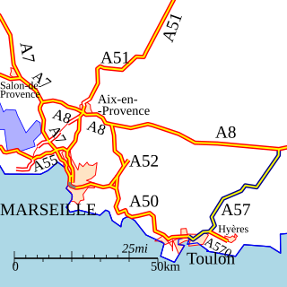
The A7 Autoroute, also known as l'autoroute du Soleil is a French motorway. It continues the A6 and links Lyon to Marseille. The autoroute du Soleil is 302.5 km (188.0 mi) long and forms part of European routes E15, E80, and E714.
The A8 autoroute, also known as La Provençale, is a 224-kilometer (139 mi)-long highway in France that runs between Aix-en-Provence and the A7 to the Côte d'Azur.
The A50 autoroute is a French motorway connecting Marseille to Toulon. The motorway is 65 km and has a mixture of 2x2 and 2x3 lanes that run through mountainous coastal terrain along the Mediterranean. As such, it has some relatively sharp turns and steep gradients by French motorway standards, and some sections have a reduced speed limit of 110 km/h.
The A52 autoroute is a 25.3 km long motorway in the Bouches du Rhone departement of southeastern France. The road links the A8 autoroute with the A50 autoroute and runs from a junction 1 km east of the Péage de La Barque on the A8 to near the town of Aubagne where it meets the A50. It is a toll road except for the very southern stretch south of the Péage du Pont d'Etoile and is operated by ESCOTA. Traffic information for the road is covered by Radio Vinci Autoroutes (FM107.7). It is a mixture of 2x2 and 2x3 lane road, with recent construction work to widen some of the 2x2 lane sections (2018).
The A54 autoroute is a toll motorway in France managed by ASF and is close to 80 km long. It is part of European route E80.
The A55 autoroute is a free motorway in southern France. It is 36.7 kilometres (22.8 mi) long.
The A57 autoroute is a motorway in south eastern France.
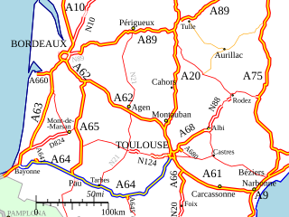
The A62 autoroute is a French motorway forming part of the Autoroute de Deux Mers. The route forms the entirety of European route E 72, which is a part of the inter-European road system. The route of the A62 / E72 is between the cities of Bordeaux and Toulouse. The E72 was previously called E76 in 1975.
The A64 autoroute is a motorway in southwestern France. It is also called the La Pyrénéenne and numbered the European route E80. It is a toll road for part of its length.
The A83 autoroute is a motorway in France. It is in the departments of Pays-de-la-Loire and Poitou-Charentes operated by ASF. It connects Nantes to Niort via Fontenay-le-Comte. The motorway has a junction with the A10 at Niort which gives access to the north and to Bordeaux connection. The A83 forms part of the Autoroute des Estuaires. The total length is 152.5 km. It is also part of the European route E3.
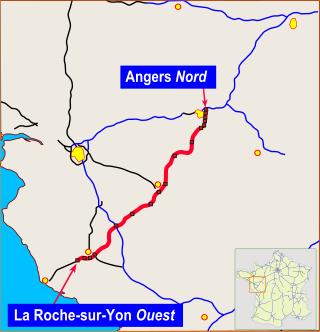
The A87 autoroute is a motorway in western France. It connects Angers with the coast and western north–south motorway the A83. It is 141.9 km (88.2 mi) long.
Avignonet is a commune in the Isère department in the Auvergne-Rhône-Alpes region of south-eastern France.
Authon is a commune in the Alpes-de-Haute-Provence department in the Provence-Alpes-Côte d'Azur region of south-eastern France.
Aubignosc is a commune in the Alpes-de-Haute-Provence department in the Provence-Alpes-Côte d'Azur region of south-eastern France.
Grenoble is the main railway station located in Grenoble, Isère, France. The station was opened on 3 January 1849 and is located on the Lyon–Marseille railway and Grenoble–Montmélian railway. The train services are operated by SNCF.
This page is based on this Wikipedia article Text is available under the CC BY-SA 4.0 license; additional terms may apply. Images, videos and audio are available under their respective licenses.