
The A38(M), commonly known as the Aston Expressway, is a motorway in Birmingham, England. It is 2 miles (3.2 km) long and was opened on 24 May 1972. It connects the M6 motorway to Aston and Central Birmingham and forms part of the much longer A38 route.
Autoroute 40, officially known as Autoroute Félix-Leclerc outside Montreal and Metropolitan Autoroute/Autoroute Métropolitaine within Montreal, is an Autoroute on the north shore of the St. Lawrence River in the Canadian province of Quebec. It is one of the two major connections between Montreal and Quebec City, the other being Autoroute 20 on the south shore of the St. Lawrence. Autoroute 40 is currently 347 km (215.6 mi) long. Between the Ontario–Quebec boundary and the interchange with Autoroute 25, the route is signed as part of the Trans-Canada Highway.

Route 132 is the longest highway in Quebec. It follows the south shore of the Saint Lawrence River from the border with the state of New York in the hamlet of Dundee, west of Montreal to the Gulf of Saint Lawrence and circles the Gaspé Peninsula. This highway is known as the Navigator's Route. It passes through the Montérégie, Centre-du-Québec, Chaudière-Appalaches, Bas-Saint-Laurent and Gaspésie regions of the province.
Autoroute 440 is a provincial highway that runs across the city of Laval, Quebec from Autoroute 13 to Autoroute 25. It is currently 18.2 km (11.3 mi) long and proceeds across Île Jésus on an east–west axis. It links every highway or expressway that connects Montreal to the North Shore.

Autoroute 13, is a freeway in the urban region of Montreal, Quebec, Canada. Its southern end is at the junction of A-20 on the Island of Montreal near Pierre Elliott Trudeau International Airport. Its northern terminus is at the junction of A-640 near Boisbriand. The road traverses Laval. A-13 is mostly six-laned and tolls were removed.
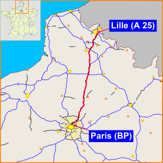
The A1 Autoroute, also known as l'autoroute du Nord, is the busiest of France's autoroutes. With a length of 211 km (131 mi), it connects Paris with the northern city of Lille. It is managed by the Société des Autoroutes du Nord et de l'Est de la France (SANEF). The autoroute serves the northern suburbs of Paris, including the Stade de France, Le Bourget, Paris' Roissy Charles de Gaulle Airport, and Parc Astérix. From there it crosses Hauts-de-France, without directly passing through any of the major cities of the région. Throughout Hauts-de-France, the A1 runs parallel to the LGV Nord.
The A131 Autoroute starts at in the outskirts of Le Havre and ends near Bourneville-Sainte-Croix close to exit 26 on the A13.

The A6, also known as the Autoroute du Soleil, Motorway of the Sun,, is an Autoroute in France, linking Paris to Lyon. The motorway starts at Paris's Porte d'Orléans and Porte d'Italie with two branches, numbered A6a and A6b respectively, that join south of Paris.
Autoroute 520 or the Côte-de-Liesse Expressway is an expressway that connects Montreal's Pierre Elliott Trudeau International Airport with Autoroute 20 at the expressway's western terminus and Autoroute 40 at the expressway's eastern terminus. This route serves as a link to the airport to residents living in the east of Montreal and the West Island as well as the city of Dorval.

The A4 Autoroute, also known as autoroute de l'Est, is a French autoroute that travels 482 km (300 mi) between the cities of Paris and Strasbourg. It forms parts of European routes E25 and E50. It is France's second longest after the A10 autoroute.

The autoroute A15 is an autoroute in the western suburbs of Paris, France.

The A2 Autoroute is a French autoroute that travels 76 km from the A1 near the commune of Combles in Picardy to the border with Belgium, where it continues on as the Belgian motorway A7. The entire length is concurrently designated as European route E19.

The A27 autoroute is a toll free autoroute in northern France, approximately 9.7 kilometres (6.0 mi) long. It forms part of European route E42.

The A23 autoroute is a highway in northern France. It is 42.5 kilometres (26.4 mi) long.

The A30 autoroute is a 29.2 kilometres (18.1 mi) long toll free highway in north eastern France. The road is also named the Autoroute de la Vallée de la Fensch. It forms part of a southern by-pass for the town of Thionville.

The A48 autoroute, also known as l'autoroute du Dauphiné, is a motorway in France connecting the A43 with the city of Grenoble.
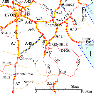
The A49 autoroute is a motorway in France. The road provides a connection between Romans (Valence) with Grenoble.
The A837 autoroute is a motorway in western France it is also known as the Autoroute des Oiseaux.
The A150 autoroute is a short motorway north west of Rouen, France. It has a total length of 17.4 kilometres (10.8 mi).

The A410 autoroute is a short motorway in France. Running through the French Alps, the road runs from West to East connecting the A40 and A41 autoroutes.


