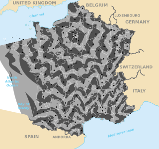
Transportation in France relies on one of the densest networks in the world with 146 km of road and 6.2 km of rail lines per 100 km2. It is built as a web with Paris at its center. Rail, road, air and water are all widely developed forms of transportation in France.

In Great Britain, there is a numbering scheme used to classify and identify all roads. Each road is given a single letter and a subsequent number. Though this scheme was introduced merely to simplify funding allocations, it soon became used on maps and as a method of navigation. There are two sub-schemes in use: one for motorways, and another for non-motorway roads.

The island of Ireland, comprising Northern Ireland and the Republic of Ireland, has an extensive network of tens of thousands of kilometres of public roads, usually surfaced. These roads have been developed and modernised over centuries, from trackways suitable only for walkers and horses, to surfaced roads including modern motorways. Driving is on the left-hand side of the road. The major routes were established before Irish independence and consequently take little cognisance of the border other than a change of identification number and street furniture. Northern Ireland has had motorways since 1962, and has a well-developed network of primary, secondary and local routes. The Republic started work on its motorway network in the early 1980s; and historically, the road network there was once somewhat less well developed. However, the Celtic Tiger economic boom and an influx of European Union structural funding, saw national roads and regional roads in the Republic come up to international standard quite quickly. In the mid-1990s, for example, the Republic went from having only a few short sections of motorway to a network of motorways, dual carriageways and other improvements on most major routes as part of a National Development Plan. Road construction in Northern Ireland now tends to proceed at a slower pace than in the Republic, although a number of important bypasses and upgrades to dual carriageway have recently been completed or are about to begin.

Controlled-access highways in Poland are part of the national roads network and they are divided into motorways and expressways. Both types of highways feature grade-separated interchanges with all other roads, emergency lanes, feeder lanes, wildlife crossings and dedicated roadside rest areas. Motorways differ from expressways in their technical parameters like designated speed, permitted road curvature, lane widths or minimal distances between interchanges. Moreover, expressways might have single-carriageway sections in case of low traffic densities.

A trunk road is a major highway with a specific legal classification in some jurisdictions, notably the United Kingdom, Sweden and formerly Ireland. Trunk roads are planned and managed at the national-level, distinguishing them from non-trunk roads which are managed by local authorities. Trunk roads are important routes usually connecting two or more cities, ports, airports and other places, which is the recommended route for long-distance and freight traffic. Many trunk roads have segregated lanes in a dual carriageway, or are of motorway standard.
A dual carriageway (BrE) or a divided highway (AmE) is a class of highway with carriageways for traffic travelling in opposite directions separated by a central reservation (BrE) or median (AmE). Roads with two or more carriageways which are designed to higher standards with controlled access are generally classed as motorways, freeways, etc., rather than dual carriageways.
A routenumber, designation or abbreviation is an identifying numeric designation assigned by a highway authority to a particular stretch of roadway to distinguish it from other routes and, in many cases, also to indicate its classification, general geographical location and/or orientation. The numbers chosen may be used solely for internal administrative purposes; however, in most cases they are also displayed on roadside signage and indicated on maps.

The road hierarchy categorizes roads according to their functions and capacities. While sources differ on the exact nomenclature, the basic hierarchy comprises freeways, arterials, collectors, and local roads. Generally, the functional hierarchy can more or less correspond to the hierarchy of roads by their owner or administrator.

A limited-access road, known by various terms worldwide, including limited-access highway, dual-carriageway, expressway, and partial controlled-access highway, is a highway or arterial road for high-speed traffic which has many or most characteristics of a controlled-access highway, including limited or no access to adjacent property, some degree of separation of opposing traffic flow, use of grade separated interchanges to some extent, prohibition of slow modes of transport, such as bicycles, horse-drawn vehicles or ridden horses, or self-propelled agricultural machines; and very few or no intersecting cross-streets or level crossings. The degree of isolation from local traffic allowed varies between countries and regions. The precise definition of these terms varies by jurisdiction.

A controlled-access highway is a type of highway that has been designed for high-speed vehicular traffic, with all traffic flow—ingress and egress—regulated. Common English terms are freeway, motorway, and expressway. Other similar terms include throughway or thruway and parkway. Some of these may be limited-access highways, although this term can also refer to a class of highways with somewhat less isolation from other traffic.

Road signs in the United Kingdom and in its associated Crown dependencies and overseas territories conform broadly to European design norms, though a number of signs are unique: direction signs omit European route numbers, and road signs generally use the imperial system of units, unlike the rest of Europe. Signs in Wales (Welsh) and parts of Scotland are bilingual.
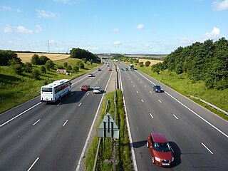
The United Kingdom has a well developed and extensive network of roads totalling about 262,300 miles (422,100 km). Road distances are shown in miles or yards and UK speed limits are indicated in miles per hour (mph) or by the use of the national speed limit (NSL) symbol. Some vehicle categories have various lower maximum limits enforced by speed limiters. A unified numbering system is in place for Great Britain, whilst in Northern Ireland, there is no available explanation for the allocation of road numbers.

The N 15 was a trunk road in France.
Switzerland has a two-class highway system: motorways with separated roads for oncoming traffic and a standard maximal speed limit of 120 kilometres per hour (75 mph), and expressways often with oncoming traffic and a standard maximal speed limit of 100 kilometres per hour (62 mph).

The National Gendarmerie is one of two national law enforcement forces of France, along with the National Police. The Gendarmerie is a branch of the French Armed Forces placed under the jurisdiction of the Ministry of the Interior, with additional duties from the Ministry of Armed Forces. Its responsibilities include policing smaller towns, suburbs and rural areas, crowd and riot control, and criminal investigation, including cybercrime. By contrast, the National Police is a civilian law enforcement agency that is in charge of policing cities and larger towns. Because of its military status, the Gendarmerie also fulfills a range of military and defence missions. The Gendarmerie has a strength of around 102,269 people.
This article describes the highway systems available in selected countries.

French roads have a variable maximum speed limit that depends on weather conditions. In dry weather, roads in urban areas have a default speed limit of 50 km/h, and outside urban areas have the following limits:

Georgia's road network plays an important role in both domestic and international traffic with the four neighboring countries. This is expressed in the road numbering system. The country has a network of 13 internationally oriented trunk highways that connect the capital Tbilisi, home to about a third of the national population, with its four neighboring countries. This is also the backbone of a network of domestic oriented national roads connecting vital regions with each other.
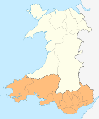
The South Wales Trunk Road Agent is one of the two trunk road agents in Wales. It is responsible for managing motorways and trunk roads in South Wales on behalf of the Welsh Government. Established on 1 April 2006 as the South Wales Trunk Road Agency, and renamed to its current name on 1 April 2012. The agent manages the motorways and trunk roads in the fourteen principal areas of the south of Wales, from the Severn Bridge in the east to Milford Haven in the west. The remainder of Wales is managed by the North and Mid Wales Trunk Road Agent.

Currently, there are three defined types of public roads in the Republic of Moldova:

