Vierzon

Last updated • 3 min readFrom Wikipedia, The Free Encyclopedia

Vierzon
Vierzon usines de la Societe Francaise 1.jpg
Factory of the Société Française
Blason Vierzon.svg
Location of Vierzon
Vierzon
France location map-Regions and departements-2016.svg
Red pog.svg
Vierzon
Centre-Val de Loire region location map.svg
Red pog.svg
Vierzon
Coordinates: 47°13′21″N2°04′10″E / 47.2225°N 2.0694°E / 47.2225; 2.0694
Country France
Region Centre-Val de Loire
Department Cher
Arrondissement Vierzon
Canton Vierzon-1 and 2
Intercommunality CC Vierzon-Sologne-Berry
Government
  Mayor (20222026) Corinne Ollivier [1]
Area
1
74.5 km2 (28.8 sq mi)
Population
 (2021) [2]
25,348
  Density340/km2 (880/sq mi)
Time zone UTC+01:00 (CET)
  Summer (DST) UTC+02:00 (CEST)
INSEE/Postal code
18279 /18100
Elevation94–182 m (308–597 ft)
(avg. 102 m or 335 ft)
1 French Land Register data, which excludes lakes, ponds, glaciers > 1 km2 (0.386 sq mi or 247 acres) and river estuaries.

Vierzon (French pronunciation: [vjɛʁzɔ̃] ) is a commune in the Cher department, Centre-Val de Loire, France.

Contents

Geography

A medium-sized town by the banks of the river Cher with some light industry and an area of forestry and farming to the north. It is situated some 33 kilometres (21 miles) northwest of Bourges, at the junction of the D2020, D2076 and the D918 roads.

Motorways encircle the town on three sides: the A85 and A71 on the north and east and the A20 on the north and west. Railways reached Vierzon in 1847 and the central SNCF hub Vierzon-Ville station, serving local and nation rail traffic, has been developed here ever since.

History

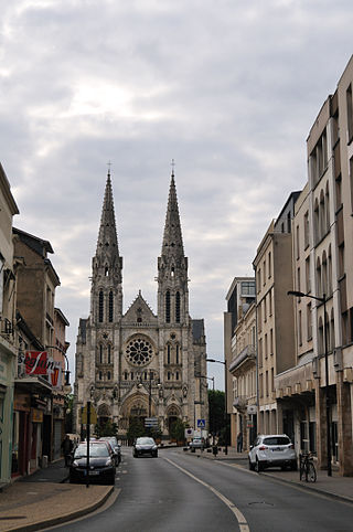
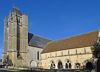
Little evidence remains of any pre-Roman occupation, and the Romans themselves didn't leave much trace of their occupation. Not until 926, when a Benedictine monastery was built (on the site of the current Town Hall) are there any records. The monks came from the abbey of Deuvre, at Saint-Georges-sur-la-Prée, after the abbey was sacked by the Normans in 903. They brought with them the relics of St. Perpetua. These relics were again transferred to the church of Notre-Dame de Vierzon in 1807, where they remain today.

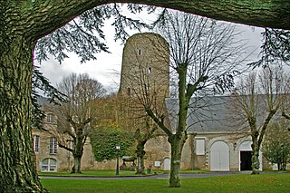
Also in the 10th century, the Normans built a castle atop a feudal motte. They became the seigneurs of Vierzon and the city developed within the western ramparts of the castle.

The Plantagenets, under Richard I Lionheart in 1196, and later Edward, the Black Prince, burned the town and took the castle. Bertrand du Guesclin drove the Plantagenets out in 1370 and restored Vierzon to the crown of France. It became a logistics centre for the armies of Joan of Arc.

Vierzon suffered during the wars of religion, but remained Catholic. The French Revolution of 1789 saw no major shocks except that the parish of Vierzon was divided into two communes: the urban part and the rural (Vierzon-Village), at the request of the rural inhabitants of the parish. In 1887, the part of town on the southern bank of the river was split into Vierzon-Bourgneuf. In 1937, following a public inquiry and a prefectoral decision, the four municipalities were united as one commune.

Vierzon has not been too troubled by more recent wars. In 1870-1871, a vanguard of Uhlan soldiers marched through the city but withdrew quickly. If Vierzon was spared by the First World War, it was sorely tried during World War II. The Cher river was the border that divided the city into two, the south of the city being in the "Free" French zone whilst the north was in the German-occupied area. In July 1944, a massive Allied bombardment destroyed a large portion of the city.

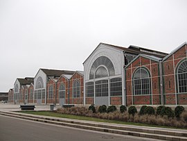
From the late 18th century until the middle of the twentieth century, the town became industrialised. Iron and steel farming tools were produced here, then glasswork and ceramics and later, agricultural machinery, notably tractors. With the demise of many factories in the town during the 1970s and 1980s, the unemployment rate was very high. This has since been reduced to the national average.

Population

The population data in the table and graph below refer to the commune of Vierzon proper, in its geography at the given years. The commune of Vierzon absorbed the former communes of Vierzon-Village, Vierzon-Bourgneuf and Vierzon-Forges in 1937. [3]

Historical population
YearPop.±% p.a.
1793 4,193    
1800 3,984−0.73%
1806 3,887−0.41%
1821 4,159+0.45%
1831 4,706+1.24%
1836 4,980+1.14%
1841 5,679+2.66%
1846 6,685+3.32%
1851 6,730+0.13%
1856 6,836+0.31%
1861 7,740+2.52%
1866 8,224+1.22%
1872 8,296+0.15%
1876 8,995+2.04%
1881 9,969+2.08%
1886 10,514+1.07%
1891 10,559+0.09%
1896 11,392+1.53%
YearPop.±% p.a.
1901 11,796+0.70%
1906 12,080+0.48%
1911 11,856−0.37%
1921 11,378−0.41%
1926 11,682+0.53%
1931 11,314−0.64%
1936 10,039−2.36%
1946 26,017+9.99%
1954 28,627+1.20%
1962 31,549+1.22%
1968 33,775+1.14%
1975 35,699+0.79%
1982 34,209−0.61%
1990 32,235−0.74%
1999 29,719−0.90%
2007 27,723−0.87%
2012 27,081−0.47%
2017 25,903−0.89%
Source: EHESS [3] and INSEE (1968-2017) [4]

Sights

The church of Notre-Dame at Vierzon Eglise Notre-Dame de Vierzon 1.jpg
The church of Notre-Dame at Vierzon

Notable people

Twin towns – sister cities

Vierzon is twinned with: [5]

Climate

Climate data for Vierzon (1991–2010 normals, extremes 1991–2014)
MonthJanFebMarAprMayJunJulAugSepOctNovDecYear
Record high °C (°F)17.2
(63.0)
20.6
(69.1)
25.2
(77.4)
30.1
(86.2)
33.7
(92.7)
38.3
(100.9)
37.4
(99.3)
40.4
(104.7)
34.4
(93.9)
28.9
(84.0)
21.9
(71.4)
17.7
(63.9)
40.4
(104.7)
Mean daily maximum °C (°F)7.2
(45.0)
8.8
(47.8)
12.9
(55.2)
16.0
(60.8)
20.2
(68.4)
23.6
(74.5)
25.9
(78.6)
25.9
(78.6)
21.4
(70.5)
16.6
(61.9)
10.6
(51.1)
7.1
(44.8)
16.4
(61.5)
Daily mean °C (°F)4.4
(39.9)
5.2
(41.4)
8.4
(47.1)
10.9
(51.6)
15.0
(59.0)
18.2
(64.8)
20.2
(68.4)
20.2
(68.4)
16.2
(61.2)
12.5
(54.5)
7.5
(45.5)
4.5
(40.1)
12.0
(53.6)
Mean daily minimum °C (°F)1.6
(34.9)
1.6
(34.9)
3.9
(39.0)
5.9
(42.6)
9.7
(49.5)
12.8
(55.0)
14.5
(58.1)
14.4
(57.9)
11.0
(51.8)
8.4
(47.1)
4.4
(39.9)
1.9
(35.4)
7.5
(45.5)
Record low °C (°F)−11.8
(10.8)
−13.1
(8.4)
−11.4
(11.5)
−2.5
(27.5)
0.2
(32.4)
4.2
(39.6)
6.7
(44.1)
5.0
(41.0)
3.0
(37.4)
−3.8
(25.2)
−9.5
(14.9)
−11.8
(10.8)
−13.1
(8.4)
Average precipitation mm (inches)65.4
(2.57)
54.7
(2.15)
58.2
(2.29)
68.7
(2.70)
69.0
(2.72)
50.4
(1.98)
63.7
(2.51)
68.3
(2.69)
72.2
(2.84)
74.7
(2.94)
74.7
(2.94)
75.9
(2.99)
795.9
(31.33)
Average precipitation days (≥ 1.0 mm)11.39.910.010.79.57.98.67.88.910.912.212.1119.7
Source: Meteociel [6]

See also

Related Research Articles

<span class="mw-page-title-main">Loir-et-Cher</span> Department of France

Loir-et-Cher is a department in the Centre-Val de Loire region of France. Its name is originated from two rivers which cross it, the Loir in its northern part and the Cher in its southern part. Its prefecture is Blois. The INSEE and La Poste gave it the number 41. It had a population of 329,470 in 2019.

<span class="mw-page-title-main">Châteauroux</span> Prefecture and commune in Centre-Val de Loire, France

Châteauroux is the capital city of the French department of Indre, central France and the second-largest town in the province of Berry, after Bourges. Its residents are called Castelroussins in French.

<span class="mw-page-title-main">Argentan</span> Subprefecture and commune in Normandy, France

Argentan is a commune and the seat of two cantons and of an arrondissement in the Orne department in northwestern France. As of 2019, Argentan is the third largest municipality by population in the Orne department.

<span class="mw-page-title-main">Saint-Amand-Montrond</span> Subprefecture and commune in Centre-Val de Loire, France

Saint-Amand-Montrond is a commune in the Cher department in the Centre-Val de Loire region of France and the historical province of Bourbonnais.

<span class="mw-page-title-main">Montluçon</span> Subprefecture and commune in Auvergne-Rhône-Alpes, France

Montluçon is a commune in central France on the river Cher. It is the largest commune in the Allier department, although the department's prefecture is located in the smaller town of Moulins. Its inhabitants are known as Montluçonnais. The town is in the traditional province of Bourbonnais and was part of the mediaeval duchy of Bourbon.

Genouilly is a commune in the Cher department in the Centre-Val de Loire region of France.

<span class="mw-page-title-main">Lignières, Cher</span> Commune in Centre-Val de Loire, France

Lignières is a commune in the Cher department in the Centre-Val de Loire region of France.

<span class="mw-page-title-main">Limeux, Cher</span> Commune in Centre-Val de Loire, France

Limeux is a commune in the Cher department in the Centre-Val de Loire region of France.

<span class="mw-page-title-main">Méreau</span> Commune in Centre-Val de Loire, France

Méreau is a commune in the Cher department in the Centre-Val de Loire region of France.

<span class="mw-page-title-main">Quincy, Cher</span> Commune in Centre-Val de Loire, France

Quincy is a commune in the Cher department in the Centre-Val de Loire region of France.

<span class="mw-page-title-main">Cerbois</span> Commune in Centre-Val de Loire, France

Cerbois is a commune in the Cher department in the Centre-Val de Loire region of France.

<span class="mw-page-title-main">Foëcy</span> Commune in Centre-Val de Loire, France

Foëcy is a commune in the Cher department in the Centre-Val de Loire region of France.

<span class="mw-page-title-main">Graçay</span> Commune in Centre-Val de Loire, France

Graçay is a commune in the Cher department in the Centre-Val de Loire region of France.

<span class="mw-page-title-main">Lazenay</span> Commune in Centre-Val de Loire, France

Lazenay is a commune in the Cher department in the Centre-Val de Loire region of France.

<span class="mw-page-title-main">Massay</span> Commune in Centre-Val de Loire, France

Massay is a commune in the Cher department in the Centre-Val de Loire region of France.

Méry-sur-Cher is a commune in the Cher department in the Centre-Val de Loire region of France.

<span class="mw-page-title-main">Saint-Christophe-le-Chaudry</span> Commune in Centre-Val de Loire, France

Saint-Christophe-le-Chaudry is a commune in the Cher department in the Centre-Val de Loire region of France.

Saint-Georges-sur-la-Prée is a commune in the Cher department in the Centre-Val de Loire region of France.

Saint-Hilaire-de-Court is a commune in the Cher department in the Centre-Val de Loire region of France.

<span class="mw-page-title-main">Château-Renault</span> Commune in Centre-Val de Loire, France

Château-Renault is a commune in the Indre-et-Loire department in central France.

References

  1. "Répertoire national des élus: les maires" (in French). data.gouv.fr, Plateforme ouverte des données publiques françaises. 13 September 2022.
  2. "Populations légales 2021" (in French). The National Institute of Statistics and Economic Studies. 28 December 2023.
  3. 1 2 Des villages de Cassini aux communes d'aujourd'hui: Commune data sheet Vierzon, EHESS (in French).
  4. Population en historique depuis 1968, INSEE
  5. "Jumelages". ville-vierzon.fr (in French). Vierzon. Retrieved 13 April 2021.
  6. "Normales et records pour Vierzon (18)". Meteociel. Retrieved 21 November 2024.