
European route E19 is a 551-kilometre (342 mi) long European route. It connects the Netherlands to France via Belgium. Among the places included in its itinerary are:

The Pays de Bray is a small natural region of France situated to the north-east of Rouen, straddling the French departments of the Seine-Maritime and the Oise. The landscape is of bocage, a land use which arises from its clay soil, and is suited to the development of pasture for the raising of dairy cattle. It produces famous butters and cheeses such as Neufchâtel.
The A1 Autoroute, also known as l'autoroute du Nord, is the busiest of France's autoroutes. With a length of 211 km (131 mi), it connects Paris with the northern city of Lille. It is managed by the Société des Autoroutes du Nord et de l'Est de la France (SANEF). The autoroute serves the northern suburbs of Paris, including the Stade de France, Le Bourget, Paris' Roissy Charles de Gaulle Airport, and Parc Astérix. From there it crosses Hauts-de-France, without directly passing through any of the major cities of the région. Throughout Hauts-de-France, the A1 runs parallel to the LGV Nord.
The Route nationale 14, N14, is a trunk road (nationale) in France between Paris and Rouen, running through Pontoise, Magny-en-Vexin, Saint-Clair-sur-Epte and Fleury-sur-Andelle. Until the 1950s, it was going until Le Havre through Yvetot.

The N 15 was a trunk road in France.

The Route nationale 2 is a route nationale in northern France.

The A26 is a 357.6 km (222.2 mi) long French motorway connecting Calais and Troyes. It is also known as the Autoroute des Anglais as its length forms the first part of the main route from the Dover-Calais ferries and the Channel Tunnel towards Southern and Eastern France and the Cote d'Azur. The motorway is used by a high proportion of British cars, particularly during the summer holiday season. The A26 between Calais and Arras is part of one of the two main routes between London and Paris, the other being the A16.

The Route nationale 9, or RN 9, is a route nationale in France between Moulins and the border with Spain across 591 kilometres.
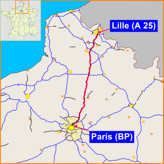
The Route nationale 1 is a trunk road (nationale) in France between Paris and Calais. It is approximately 339 km (211 mi) long.
The Route nationale 11, or RN11, is a trunk road (nationale) in Southwest France between Poitiers and La Rochelle. It is part of European route E611.
The Route nationale 12, or RN12, is a trunk road (nationale) in France connecting Paris with Brittany. The road forms part of European route E50. It is approximately 570 km (350 mi) long.
The Route nationale 16, or RN16, is a trunk road (nationale) in France crossing Picardy north of Paris.
The Route nationale 17, or RN17, is a trunk road (nationale) in France connecting Paris to the border with Belgium.
The Route nationale 23 (N23) is a trunk road (nationale) in western France.
The Route nationale 27 is a highway in Normandy, north west France. It connects the city of Rouen to the port of Dieppe.
The Route nationale 28 is a trunk road in Normandy and Picardy in northwest France. It connects the city of Rouen to the port of Dunkerque. Most of the route has been superseded by the A28 autoroute.
The Route nationale 29 is a highway in Normandy and Picardy, northeast France. It connects the city port of Le Havre with Amiens, Saint-Quentin and the Belgian frontier. Most of the route has been superseded by the A29 autoroute.
The Route nationale 31 is a motorway in northern France. It connects the town of Rouen to Reims, it is also the European Route 46.
The A150 autoroute is a short motorway north west of Rouen, France. It has a total length of 17.4 kilometres (10.8 mi).

Gournay-en-Bray is a commune in the Seine-Maritime department in the Normandy region in north-western France.
