
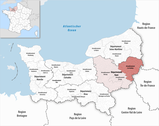
Val-d'Oise is a department in the Île-de-France region, Northern France. It was created in 1968 following the split of the Seine-et-Oise department. In 2019, Val-d'Oise had a population of 1,249,674.

Pontoise is a commune in the northwestern suburbs of Paris, France. It is located 28.4 km (17.6 mi) from the centre of Paris, in the "new town" of Cergy-Pontoise.
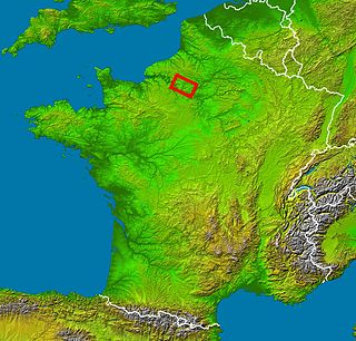
Vexin is an historical county of northwestern France. It covers a verdant plateau on the right bank (north) of the Seine running roughly east to west between Pontoise and Romilly-sur-Andelle, and north to south between Auneuil and the Seine near Vernon. The plateau is crossed by the Epte and the Andelle river valleys.

The Pays de Bray is a small natural region of France situated to the north-east of Rouen, straddling the French departments of the Seine-Maritime and the Oise. The landscape is of bocage, a land use which arises from its clay soil, and is suited to the development of pasture for the raising of dairy cattle. It produces famous butters and cheeses such as Neufchâtel.

The arrondissement of Pontoise is an arrondissement of France in the Val-d'Oise department in the Île-de-France region. It has 105 communes. Its population is 346,946 (2019), and its area is 766.0 km2 (295.8 sq mi).
The arrondissement of Les Andelys is an arrondissement of France in the Eure department in the Normandy region. It has 185 communes. Its population is 235,732 (2016), and its area is 1,854.4 km2 (716.0 sq mi).

The Arrondissement of Rouen is an arrondissement of France in the Seine-Maritime department in the Normandy region. It has 216 communes. Its population is 631,032 (2016), and its area is 1,936.1 km2 (747.5 sq mi).

Autoroute 13, or L'Autoroute de Normandie links Paris to Caen, Calvados.

The N13 is a trunk road in France between Paris and Cherbourg.

The N 15 was a trunk road in France.

The Route nationale 2 is a route nationale in northern France.

The Route nationale 7, or RN 7, is a trunk road (nationale) in France between Paris and the border with Italy. It was also known as Route des vacances, Route bleue, and — sarcastically, during the annual rush to the Mediterranean beaches — the Route de la mort.
The Route nationale 1 is a trunk road (nationale) in France between Paris and Calais. It is approximately 339 km (211 mi) long.
The Route nationale 16, or RN16, is a trunk road (nationale) in France crossing Picardy north of Paris.

The Route nationale 19 (N19) is a trunk road (nationale) in north east France. The road forms part of European route E54.
Chaussée Jules César was a Roman road linking Lutetia (Paris) and Rotamagus (Rouen). The road's construction was initiated by the Roman governor Marcus Vipsanius Agrippa. Linking two important cities of Roman Empire in Gaul, the road possessed inns and postal relays every 15 km, thereby enabling mail to travel between Paris and Rouen within a day.
The Route nationale 29 is a highway in Normandy and Picardy, northeast France. It connects the city port of Le Havre with Amiens, Saint-Quentin and the Belgian frontier. Most of the route has been superseded by the A29 autoroute.

The Paris–Le Havre railway is an important 228-kilometre long railway line, that connects Paris to the northwestern port city Le Havre via Rouen. Among the first railway lines in France, the section from Paris to Rouen opened on 9 May 1843, followed by the section from Rouen to Le Havre that opened on 22 March 1847.
The canton of Vauréal is an administrative division of the Val-d'Oise department, Île-de-France region, northern France. It was created at the French canton reorganisation which came into effect in March 2015. Its seat is in Vauréal.

The canton of Chaumont-en-Vexin is an administrative division of the Oise department, northern France. Its borders were modified at the French canton reorganisation which came into effect in March 2015. Its seat is in Chaumont-en-Vexin.
