Route nationale 9

Last updated
Double-face milestone in Clermont-Ferrand. Borne RN 9 Perignat Riom.jpg
Double-face milestone in Clermont-Ferrand.

The Route nationale 9, or RN 9, is a route nationale [1] in France between Moulins and the border with Spain across 591 kilometres.

Contents

Reclassification

Much of the N9 has now been upgraded or replaced by the A75 autoroute; in particular the section south of Clermont-Ferrand to Béziers. Depending on which Department the road is in, the old road is now numbered as various Route Départementale numbers:

Route Description

Moulins - Clermont-Ferrand - Béziers - Narbonne - Perpignan - Spain

Moulins to Clermont Ferrand (0 km to 103 km)

The road begins in Moulins at a junction with the N7 on the Rue de l'Horloge. The road weaves through the city and crosses the Allier river across the Pont Régemortes. The road follows the West bank of Allier to Saint-Pourçain-sur-Sioule crossing the Sioule river and following it South. At Gannat the road meets the A719, which connects Vichy, 20km to the East, and the A71 autoroute. The N9 continues South to Riom and the volcanic region of Auvergne. The road is dual-carriageway for 10km into the industrial city of Clermont-Ferrand.

Clermont Ferrand to Béziers (103 km to 444 km)

After Clermont-Ferrand the road heads through the Massif Central countryside. Much of the N9 has now been upgraded or replaced by the A75 autoroute between Clermont-Ferrand and Béziers.

The original N9 has now been renumbered D909 and passes through small villages and towns bypassed by the A75 which now takes the majority of through traffic. The route follows the upper Allier valley to Issoire before joining the Gorges de l'Allagnon and then climbing to cross the Col de la Fageole (1114m) and onto Saint-Flour and the Gorges de l’Ander. The old N9 then follows the banks of the dammed river Truyère under the Viaduc de Garabit .

The surroundings are very scenic consisting of rolling green wooded hills and steep sided river vallies, as the road is now crossing the edge of the Aubrac plateau. The road has a junction with the old N106, now D806 at Saint-Chély-d'Apcher. The road then crosses the Col des Issartets (1121m), the highest point of the road, after which the former route of the N9 passes to the East of the autoroute passing through the small town of Marvejols and into the Lot valley.

The road then enters Causse country a series of barren limestone plateaus divided by deep river valleys. The road passes between the Causse de Sévérac and Causse de Sauveterre before reaching Sévérac-le-Château and the N88 which heads to the West.

The road passes the source of the Aveyron and into the Parc Natural Régional des Grandes Causses. After crossing the Col d'Engayresque (888m) the N9 re-appears and drops into the Gorges du Tarn and onto Millau where the road crosses the river and climbs up to the Causse du Larzac offering views of the valley and viaduct. The N9 provides a free alternative for avoiding the toll on the A75 as it crosses the valley on the Viaduc de Millau. The N9 has again been replaced by the A75 for this section.

At the Pas de l'Escalette just South of Le Caylar the road enters a gorge leading South off the Causse du Larzac and on toward the coastal plain and the Mediterranean. Historically, the N9 used to cross the river Lergue at Pegairolles de l'Escalette and follow what is now the treacherous D149 right through the city of Lodève. After a series of improvements starting in 1969, the road now stays on the left bank of the Lergue and bypasses Lodève. It skirts the Lac du Salagou, which it once ran right through, before reaching Clermont l'Hérault and a junction with the N109 to Montpellier. The N9 demerges from the A75 autoroute again at Clermont-l'Hérault, and follows the Hérault Valley south through Pézenas. The roads run parallel to each other until just to the North-East of Béziers when the A75 turns South-East to intersect the A9 autoroute.

Béziers to Perthus (444 km to 591 km)

After Béziers the A9 autoroute runs parallel to the route of the N9 and takes the majority of through traffic from Béziers. There the road crosses the Canal du Midi and river Orb and continues over the river Aude to Narbonne. The section south of Béziers is reclassified as the D6009. Thereafter the road heads along the Étang de Bages et de Sigean as the mountains push further East. The road is overlooked here by the Massif de Fontfroide and thereafter heads through the vineyards of Fitou. The road passes round the shores of the Étang de Leucate ou de Salses .

The road enters Northern Catalonia at the Fort de Salses . The road is downgraded to D900 and passes through the plain of Roussillon to the city of Perpignan where it crosses the rivers Têt and Tech. The plain is dominated by the Pyrénées to the South and the Corbières Massif to North. It then passes Le Boulou where it enters the Monts Albères which form the Eastern ridge of the Pyrénées. The road climbs to the border at Le Perthus and the Col du Perthus where the road enters Spain, in the village of Els Límits. The road continues as the N-II in Spain.

History

The route was initially conceived by Napeleon as part of the 1811 Route Impériale system as Route Impériale 10. It was defined as: "The road between Paris and Perpignan ". After Napeleon's downfall it was renamed to Route Royale 9. It was finally changed to Route Nationale 9 after France became a republic. The route has stayed the same for the most part, with minor changes and upgrades made over time.

Throughout the 20th century, the N9 has built up somewhat of a negative reputation. The road was narrow, rough, and extremely accident prone due to the extensive mountain sections. Widening or upgrading the road was difficult due to the equally difficult to work with terrain. Starting in the 1960's, studies were launched in order to improve the N9 in the Massif Central. It started small, a few expressways near Clermont-Ferrand and the Lodève bypass in the late 60's. In 1969, the treacherous section North of Lodève, now known as the D149 was bypassed. In 1978, most of the Pas de l'Escalette was reworked into dual-carriageway. Most of these sections would later end up as part of the A75. As the A75 was being built, the N9 quickly lost most of its use and was gradually downgraded as more parts of the A75 opened. In 1992, most of the section between Clermont-Ferrand and Béziers was downgraded, and later in 2006, almost the entire remaining section was downgraded. All that's left of the N9 today is a small section in Massiac spanning 2 kilometres.

Related Research Articles

<span class="mw-page-title-main">Hérault</span> Department in Occitanie, France

Hérault is a department of the region of Occitania, Southern France. Named after the Hérault River, its prefecture is Montpellier. It had a population of 1,175,623 in 2019.

<span class="mw-page-title-main">Larzac</span>

Larzac, also known as the Causse of Larzac, is a limestone karst plateau in the south of the Massif Central, France, situated between Millau and Lodève. It is an agricultural area, where traditionally sheep produce milk for Roquefort cheese. Since the early 2010s, the agricultural production has largely diversified.

<span class="mw-page-title-main">Massif Central</span> Highland region in southern France

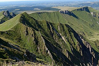
The Massif Central is a highland region in south-central France, consisting of mountains and plateaus. It covers about 15% of mainland France.

<span class="mw-page-title-main">Millau Viaduct</span> Cable-stayed bridge in Occitanie, France

The Millau Viaduct is a multispan cable-stayed bridge completed in 2004 across the gorge valley of the Tarn near Millau in the Aveyron department in the Occitanie Region, in Southern France. The design team was led by engineer Michel Virlogeux and English architect Norman Foster. As of October 2023, it is the tallest bridge in the world, having a structural height of 336.4 metres (1,104 ft).

<span class="mw-page-title-main">Tarn (river)</span> River in southern France

The Tarn is a 380.2-kilometre (236.2 mi) long river in the administrative region of Occitania in southern France. It is a right tributary of the Garonne.

<span class="mw-page-title-main">A75 autoroute</span> Motorway in southern France

The A75 is an autoroute (motorway) in France.

<span class="mw-page-title-main">Autoroutes of France</span> Highway system of France

The autoroute system in France consists largely of toll roads. It is a network of 11,882 km (7,383 mi) of motorways as of 2014. On road signs, autoroute destinations are shown in blue, while destinations reached through a combination of autoroutes are shown with an added autoroute logo. Toll autoroutes are signalled with the word péage.

<span class="mw-page-title-main">Route nationale 7</span> Road in France

The Route nationale 7, or RN 7, is a trunk road (nationale) in France between Paris and the border with Italy. It was also known as Route des vacances, Route bleue, and — sarcastically, during the annual rush to the Mediterranean beaches — the Route de la mort.

The Route nationale 1 is a trunk road (nationale) in France between Paris and Calais. It is approximately 339 km (211 mi) long.

The Route nationale 6 is a trunk road (nationale) in France between Paris and the frontier with Italy in the Alps.

The Route nationale 8, or RN 8, was a trunk road (nationale) in southeast France between Aix-en-Provence and Toulon.

<span class="mw-page-title-main">Route nationale 10</span> French route nationale

Route nationale 10, or RN 10, is a trunk in France between Paris and the border with Spain via Bordeaux.

The Route nationale 16, or RN16, is a trunk road (nationale) in France crossing Picardy north of Paris.

The Route nationale 17, or RN17, is a trunk road (nationale) in France connecting Paris to the border with Belgium.

<span class="mw-page-title-main">Route nationale 19</span> Road in France

The Route nationale 19 (N19) is a trunk road (nationale) in north east France. The road forms part of European route E54.

<span class="mw-page-title-main">Route nationale 20</span> Road in France

The Route nationale 20 (N20) is a trunk road (nationale) between Paris and the frontier with Spain heading south through the heart of France and passing through the Cathedral City of Orléans and Toulouse. The road forks at Col de Puymorens with one branch being the Route nationale 22 which leads to Andorra. In winter, avalanches sometimes close the road.

<span class="mw-page-title-main">A9 autoroute</span> Road in France

The A9 autoroute is a motorway in Southern France.

<span class="mw-page-title-main">A71 autoroute</span> Road in France

The A71 autoroute is a motorway in central France. It is also called l'Arverne. It starts at Orléans and ends at Clermont-Ferrand.

The Route nationale 23 (N23) is a trunk road (nationale) in western France.

<span class="mw-page-title-main">Béziers to Neussargues Railway</span> French rail transport.

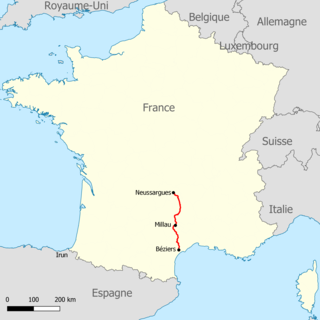
The Béziers to Neussargues Railway, also known as the Causses Railway, is a French rail transport connecting Béziers, near the Languedoc coast, to Neussargues in the department of Cantal, crossing the Millau and the Causses plateaus.

References

  1. "R.N.9: LA VOIE DES ARVERNES (I)". surma-route.net (in French). Retrieved 13 August 2023.