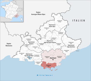
Var is a department in the Provence-Alpes-Côte d'Azur region in Southeastern France. It is bordered on the east by the Alpes-Maritimes department; to the west by Bouches-du-Rhône; to the north of the river Verdon by the Alpes-de-Haute-Provence department; and to the south by the Mediterranean Sea. It had a population of 1,076,711 in 2019.

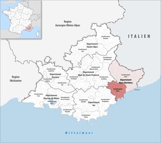
Alpes-Maritimes is a department of France located in the country's southeast corner, on the Italian border and Mediterranean coast. Part of the Provence-Alpes-Côte d'Azur region, it encompasses the French Riviera alongside neighbouring Var. Alpes-Maritimes had a population of 1,094,283 in 2019. Its prefecture is Nice, with Grasse as the sole subprefecture.

Provence-Alpes-Côte d'Azur, also known as Région Sud, is one of the eighteen administrative regions of France, the far southeastern on the mainland. Its prefecture and largest city is Marseille.

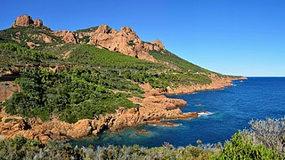
The French Riviera, known in French as the Côte d'Azur, is the Mediterranean coastline of the southeast corner of France. There is no official boundary, but it is usually considered to extend from Cassis, just east of Marseille, to Menton, at the France–Italy border, although some other sources place the western boundary further east around Toulon or Saint-Tropez. The coast is entirely within the Provence-Alpes-Côte d'Azur region of France. The Principality of Monaco is a semi-enclave within the region, surrounded on three sides by France and fronting the Mediterranean. The French Riviera contains the seaside resorts of Cap-d'Ail, Beaulieu-sur-Mer, Saint-Jean-Cap-Ferrat, Villefranche-sur-Mer, Antibes, Juan-les-Pins, Cannes, Saint-Raphaël, Fréjus, Sainte-Maxime and Saint-Tropez.

Saint-Raphaël is a commune in the Var department, Provence-Alpes-Côte d'Azur region, Southeastern France. In 2017, it had a population of 35,042.
The arrondissement of Grasse is an arrondissement of France in the Alpes-Maritimes department in the Provence-Alpes-Côte d'Azur region. It has 62 communes. Its population is 561,067 (2016), and its area is 1,231.2 km2 (475.4 sq mi).

The arrondissement of Nice is an arrondissement of France in the Alpes-Maritimes department in the Provence-Alpes-Côte d'Azur region. It has 101 communes. Its population is 522,637 (2016), and its area is 3,067.4 km2 (1,184.3 sq mi).
The arrondissement of Toulon is an arrondissement of France in the Var department in the Provence-Alpes-Côte d'Azur region. It has 32 communes. Its population is 567,852 (2016), and its area is 1,233.5 km2 (476.3 sq mi).
This is a list of the 27 cantons of the Alpes-Maritimes department, in France, following the French canton reorganisation which came into effect in March 2015:
The following is a list of the 23 cantons of the Var department, in France, following the French canton reorganisation which came into effect in March 2015:

Mandelieu-la-Napoule is a commune in the Alpes-Maritimes department of the Provence-Alpes-Côte d'Azur region in Southeastern France. Located on the French Riviera, just to the southwest of Cannes and northeast of Théoule-sur-Mer, it had a population of 21 772 in 2020.

The Route nationale 7, or RN 7, is a trunk road (nationale) in France between Paris and the border with Italy. It was also known as Route des vacances, Route bleue, and — sarcastically, during the annual rush to the Mediterranean beaches — the Route de la mort.

The A8 autoroute, also known as La Provençale, is a 224-kilometer (139 mi)-long highway in France that runs between Aix-en-Provence and the A7 to the Côte d'Azur.

The A50 autoroute is a French motorway connecting Marseille to Toulon. The motorway is 65 km and has a mixture of 2x2 and 2x3 lanes that run through mountainous coastal terrain along the Mediterranean. As such, it has some relatively sharp turns and steep gradients by French motorway standards, and some sections have a reduced speed limit of 110 km/h.

Théoule-sur-Mer, popularly known as Théoule, is a resort village in the Alpes-Maritimes department in the Provence-Alpes-Côte d'Azur region in Southeastern France. It lies to the east of the Esterel Massif, on the French Riviera. Théoule-sur-Mer is on the border with the Var department, 6 km (3.7 mi) south of Mandelieu-la-Napoule. In 2018, it had a population of 1,350.
The Gardens of Provence-Alpes-Côte d'Azur is a list and description of the parks and gardens in the region, which are classified by the Committee of Parks and Gardens of the French Ministry of Culture as among the Notable Gardens of France.

The Marseille–Ventimiglia railway is a French-Monégasque-Italian 259-kilometre-long (161 mi) railway line. It opened in several stages between 1858 and 1872.
The canton of Mandelieu-la-Napoule is an administrative division of the Alpes-Maritimes department, southeastern France. It was created at the French canton reorganisation which came into effect in March 2015. Its seat is in Mandelieu-la-Napoule.

